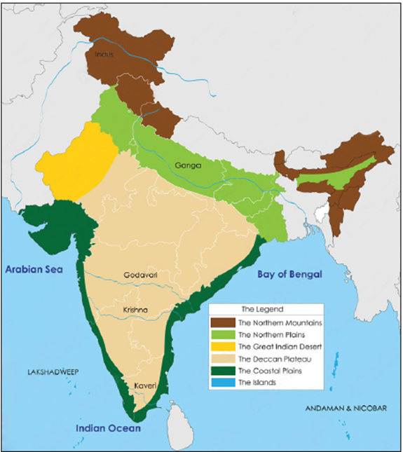
India is divided into 6 Physiographic Divisions namely Northern Mountains, Northern Plains, Peninsular Region, Indian Deserts, Coastal Plains and Indian Islands.
- Himalayas are the globally Highest and Youngest fold mountains providing a climatic divide shielding India from cold Siberian Winds and allow the onset of monsoon rains in the Indian subcontinent.
- The highly populated region of the Northern Plains is formed by accumulation of sediments from River Ganga, Yamuna and Brahmaputra forms the Northern Plains.
- The Peninsular Plateau is a highly stable and Oldest part of the Physiography of India.
- The Thar or the Indian Desert is located on the west of Aravali Hills and is known for crescent shaped sand dunes- ‘Barchans’ and Luni River.
- The Narrower Western Coastal plains includes Konkan and Malabar coasts whereas the Broader Eastern coastal plains includes Coromandel and is home to India’s largest saltwater Chilika lake.
- The Island with coral deposits namely Lakshadweep and Andaman Nicobar Islands which is an extension of the Arakan Yoma ranges in Myanmar forms the Indian Islands.
What is Physiography?
Physiography is the branch of geography that studies the physical features of the earth’s surface and their relation to its geological structures. In simple terms, the physiography of a region describes the physical characteristics of the region, including mountains, rivers, valleys, plains, and plateaus.
What is the Physiographic Division?
Physical division refers to a distinct area of land within a larger region, which possesses its own distinctive landforms and geological features. In simple terms, they effectively categorize large areas based on a common set of physical features.
The concept of physiographic divisions allows us to classify, study, and manage different areas of a vast region according to their physical characteristics and natural environments.
6 Physiographic Divisions of India
The vast expanse of India encompasses a great diversity of relief features. Based on these features, India has been divided into the following 6 physiographic divisions:
(1) The Himalayan Mountains
(2) The Northern Plains
(3) The Peninsular Plateau
(4) The Indian Desert
(5) The Coastal Plains
(6) The Islands
A brief description of each of the 6 Physical divisions of India is given in the sections that follow.
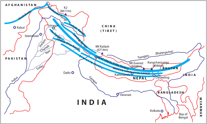
The Himalayas
The Himalayas are young fold mountains formed by the convergence of two tectonic plates. They act as a dividing range between the Tibetan Plateau in the north and the Indian Subcontinent in the south. They also act as a water divide between the Indo-Gangetic and Tibetan river systems.
- Origin: The Himalayas were formed several million years ago as a result of the convergence of the Indo-Australian Tectonic Plate with the Eurasian (Asian) Tectonic Plate.
- Latitudinal Divisions of Himalayas: Based on the latitudinal extent, the Himalayas can be divided into 3 divisions:
- Trans-Himalayas.
- The Himalayan Mountain Ranges.
- The Eastern Hills or Purvanchal.
- Longitudinal Divisions of Himalayas: Based on the longitudinal extent, the Himalayas have been divided into 4 regional divisions:
- Punjab Himalayas
- Kumaon Himalayas
- Nepal Himalayas
- Assam Himalayas
Read our Detailed Article on the Himalayas.
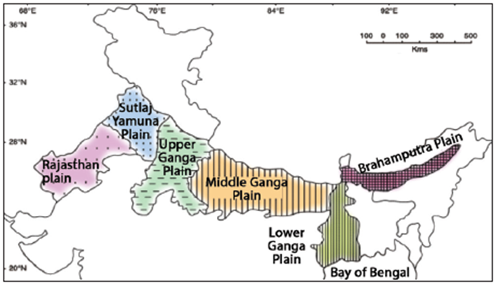
The Great Plains of North India
The Indo-Gangetic Plains, also known as the Indo-Gangetic-Brahmaputra Plains or the Great Plains of North India, refer to an aggradational plain formed by the alluvial deposits carried by the three rivers – Indus, Ganga, Brahmaputra, and their tributaries. Located to the south of the Himalayas and extending from the mouth of the Indus in the west to the mouth of the Ganga in the east, it forms an important physiographic division of India.
- Origin: These plains are formed by the depositional works of the three rivers – Indus, Ganga, and Brahmaputra, and their tributaries. The sediments of these rivers filled the wide depression that existed between the Peninsular and Himalayan regions.
- Regional Divisions of the Indo-Gangetic Plains: Regionally, the Indo-Gangetic Plains are classified intodescribe how the himalayas were formed 4 major divisions:
- The Rajasthan Plain
- The Punjab-Haryana Plain
- The Ganga Plain
- The Brahmaputra Plain
Read our detailed article on the Indo-Gangetic Plains.
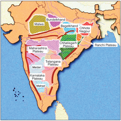
The Peninsular Plateau of India
The Peninsular Plateau of India, also known as the Indian Peninsular Plateau, forms an important physiographic division of India. It refers to the flat tableland that lies in the southern part of India and is surrounded by the oceans on three sides. Along with being the oldest landmass of India, it also holds the distinction of being the largest physiographic division of India.
- Major Plateaus of Peninsular India: The Peninsular Plateau of India or the Indian Peninsular Plateau, as a physiographic unit, consists of several smaller plateaus. The prominent smaller plateaus of Peninsular India include:
- The Marwar Upland
- The Central Highlands (or the Madhya Bharat Pathar)
- The Bundelkhand Upland
- The Malwa Plateau
- The Baghelkhand
- The Chotanagpur Plateau
- The Meghalaya Plateau (Shillong Plateau)
- The Deccan Plateau
- The Chhattisgarh Plain
- Major Hill Ranges of Peninsular India: The plateaus of Peninsular India are divided from one another by river valleys and hill ranges. Major hill ranges of Peninsular India include:
- The Aravali Range
- The Vindhyan Range
- The Satpura Range
- The Western Ghats (or the Sahyadris)
- The Eastern Ghats
Read our Detailed article on the Peninsular Plateau of India.
The Indian Desert
The Indian Desert, also known as the Thar Desert or the Great Indian Desert, lies in northwestern India, covering about 200,000 sq. km—85% in India (mainly Rajasthan, also Gujarat, Punjab, Haryana) and 15% in Pakistan. It makes up nearly 4.5% of India’s total area and is globally the world’s 18th largest desert and 9th largest hot subtropical desert.
Location and Extent
- Mostly in western Rajasthan, extends into Gujarat, Punjab, Haryana in India, and Sindh, Punjab in Pakistan.
- Bordered by the Indus River plain (west), Aravalli Range (east), Rann of Kutch (south), Punjab plains (north and northeast).
Climate and Features
- Hot, subtropical climate; very low rainfall (100-500 mm annually, mainly July-September).
- Terrain dominated by sand dunes, some shifting, sparse vegetation, saline lakes like Sambhar and Kuchaman, and the Luni River as the only river.
- The soil is coarse, sandy, saline, and calcareous, supporting drought-resistant grasses, shrubs, and some agriculture.
Biodiversity and Human Aspects
- Despite aridness, it is the most densely populated desert in the world.
- Home to species like Blue Bull (Nilgai), Blackbuck, Chinkara, and the Great Indian Bustard; Desert National Park is located here.
- Economy: agriculture (mainly in irrigated zones like Indira Gandhi Canal), livestock, mining of minerals like gypsum, salt, and lignite.
- Rich in culture with annual desert festivals, vibrant traditions, and tourism in historic cities like Jodhpur.
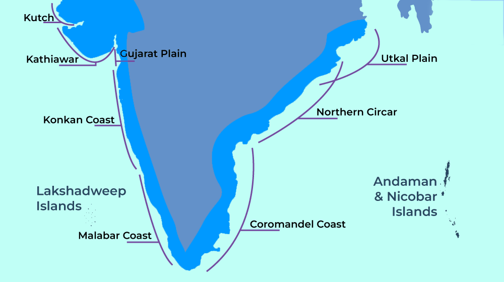
The Coastal Plains of India
The Coastal Plains of India refers to the stretch of narrow coastal strip lying between the edges of the Peninsular Plateau and the coastline of India. As one of the 6 physiographic divisions of India, these plains stretch for a distance of about 6000 km along the Arabian Sea in the west and the Bay of Bengal in the east.
- Divisions of the Coastal Plains of India: These plains can be divided into two parts:
- The Western Coastal Plains of India
- The Eastern Coastal Plains of India
Read our Detailed article on the Coastal Plains of India.
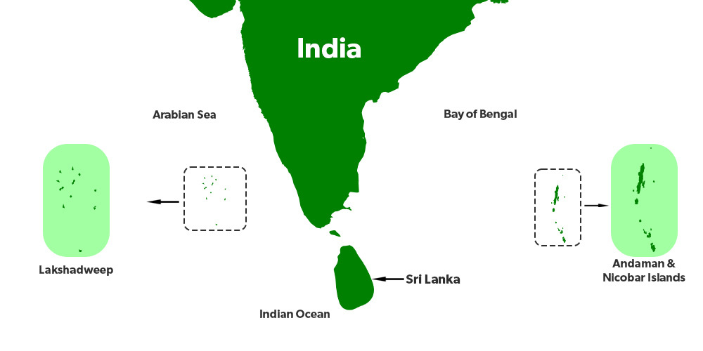
The Indian Islands
The Indian Islands or the islands of India refer to the group of islands, scattered across the Indian Ocean, the Arabian Sea, and the Bay of Bengal, which form parts of the territory of India. Together, they constitute one of the 6 physiographic divisions of India.
The Indian Islands or the Islands in India are, broadly, categorized into two main groups of islands:
- The Andaman and Nicobar Islands
- The Lakshadweep Islands
Read our Detailed article on the Indian Islands.
These diverse physiographic divisions of India highlight the diversity of the vast geography of our country. With their own unique physical features, climate, vegetation, and soil types, each of the physiographic divisions of India contributes uniquely to the country’s geographical diversity, cultural richness, and economic activities. Understanding these divisions is not only essential for sustainable development but also for better planning and management of its natural resources.
GS - 1


