The Peninsular Plateau of India is the most stable part of India belonging to the Gondwana period. The Deccan Traps on the peninsular plateau were formed of massive volcanic eruptions in the past. The fertile Black or Regur soil therefore prevails in the region which is important for Indian Cotton & Sugarcane industries.
The Chota nagpur Plateau also known as the ‘Mineral Heartland of India’ is located here. In the Plateau area a Gold Mine is located in Kolar, Karnataka and also a Diamond Mine in Panna, Madhya Pradesh. The plateau has a west to east slope which influences the river drainage system. The east flowing rivers like Godavari, Krishna & Kaveri complete the water requirement in the region & drain into the Bay of Bengal. Locationwise, the Peninsular plateau lies south of the Northern Plains and is bordered by the Western Ghats and Eastern Ghats. Most Interestingly, the Meghalaya Plateau in North East India is also a part of the Indian Peninsular Plateau.
About the Peninsular Plateau of India
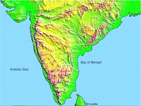
The Peninsular Plateau of India, also known as the Indian Peninsular Plateau, refers to the flat tableland that lies in the southern part of India and is surrounded by the oceans on three sides. It constitutes one of the 5 physiographic divisions of India. Along with being the oldest landmass of India, it also holds the distinction of being the largest physiographic division of India.
Features of the Peninsular Plateau of India
- Shape: It is roughly triangular.
- Its broad base lies at the southern edge of the Indo-Gangetic Plains. From here, it tapers downwards up to Kanyakumari.
- Extent: Its northern boundary is an irregular line running from Kutch along the western flank of the Aravalis to areas near Delhi, which then moves roughly parallel to the Yamuna and the Ganga up to the Rajmahal Hills and the Ganga Delta.
- Boundaries: It is surrounded by hill ranges on all three sides:
- In the north, it is bounded by the Aravali Range, the Vindhya, the Satpura, the Bharmer, and the Rajmahal Hills.
- In the west, it is bounded by the Western Ghats.
- In the east, it is bounded by the Eastern Ghats.
- Area: Peninsular India is the largest physiographic unit of India with an area of 16 lakh sq. km.
- The area occupied by the Peninsular Plateau of India equals almost half of the area of the country.
- Composition: This old tabular block is made of schists and Archaean genesis.
- It is regarded as a stable shield that hasn’t had many structural alterations since it first formed.
- Slope: The Peninsular block slopes mostly from west to east.
- This is the reason major peninsular rivers (except Narmada and Tapi) flow from west to east and drain into the Bay of Bengal.
- Elevation: The average height of the Peninsular Plateau of India is 600–900 meters above the mean sea level.
Geomorphology of Indian Peninsular Plateau
The Peninsular Plateau of India is made up of many smaller plateaus and hill ranges, interspersed with river basins and valleys. Thus, studying the geomorphology of Peninsular India entails studying major plateaus and major hill ranges in the region. The same are explained in detail in the sections that follow.
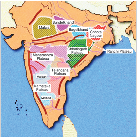
Major Plateaus of Peninsular India
The Peninsular Plateau of India or the Indian Peninsular Plateau, as a physiographic unit, consists of several smaller plateaus. The prominent smaller plateaus of Peninsular India are described as follows:
The Marwar Upland
- Location: It is located to the east of the Aravali Range.
- It is for this reason it is also called the Upland of Eastern Rajasthan.
- Elevation & Slope: The average elevation of this part of the Indian Peninsular Plateau is 250-500 m, and it slopes eastwards.
- Composition: It is made up of Sandstone, Shales, and Limestones of the Vindhyan period.
- Rivers: River Banas, a tributary of River Chambal, originates from the Vindhyan Range and then flows through this region.
- Topography: It is a region of rolling plateau with rounded hills and forest.
- The erosional works of River Banas and its tributaries have played an important role in shaping the topography of this region.
The Central Highlands (Madhya Bharat Pathar)
- Location: It is located to the east of the Marwar Upland.
- Most of it lies in the Chambal River Basin.
- Composition: This part of the Peninsular Plateau of India is made up of old rocks and some interspersed rounded hills composed of sandstone.
- Rivers: Chambal River flows in a rift valley through this region.
- Topography: It is an open rolling plateau.
- Ravines or Badlands of River Chambal.
The Bundelkhand Upland
- Location: It is bounded by the Yamuna River to the north, Madhya Bharat Pathar to the west, Vindhyan Scarplands to the east and southeast, and Malwa Plateau to the south.
- Spread: It spreads over the Uttar Pradesh-Madhya Pradesh border and surrounding areas in the two states.
- Elevation & Slope: It has an average elevation of 300-600 m above the mean sea level with the plateau sloping down from the Vindhyan Scarp toward the Yamuna River.
- Composition: It is an old dissected upland made up of ‘Bundelkhand Gneiss’ comprising Granite and Gneiss.
- Rivers: The prominent rivers flowing in the area include the Betwa, Dhasan, and Ken.
- Topography: Senile topography is a characteristic of this region of the Indian Peninsular Plateau.
- The erosional work of the rivers flowing in this region has made this area undulating (wave-like surface), and hence unfit for cultivation.
- Also, the area is marked by a chain of hillocks (small hills) made of Granite and Sandstone.
The Malwa Plateau
- Location: It is a triangular-shaped plateau.
- Its base lies on the Vindhyan Hills in the north and is bounded by the Aravali Range in the west and Bundelkhand in the east.
- The plateau constitutes an extension of the Deccan Traps.
- Elevation: The general height of the plateau is 600 m in the south which steeps down to 500 m in the north.
- Composition: It has been formed by basaltic lava flow, and hence is covered with black soils.
- Rivers: It is drained by two drainage systems:
- The first one, flowing towards the Arabian Sea includes – The Narmada, the Tapi, and the Mahi.
- The other one, flowing towards the Bay of Bengal includes – Chambal, Sindh, Betwa, and Ken.
- Topography: The region of the Peninsular Plateau of India comprises rolling surfaces with flat-topped hills dissected by rivers.
- The plateau is marked by the Chambal ravines in the north.
The Baghelkhand
- Location: It lies to the east of the Maikal Range.
- It is bounded by the Son River on the north and anticlinal highlands and synclinal valleys made up of sandstones and limestones in the south.
- Elevation: The region has a general elevation of 150 m to 1200 m.
- Composition: Its western part is made up of limestone and sandstones. Its eastern part, on the other hand, is composed of granite.
- Rivers: The central part of the plateau acts as a water divide between the drainage systems of the Son River in the north and the Mahanadi River in the south.
- Topography: The region of the Peninsular Plateau of India has uneven relief.
- It comprises the scarps of the Vindhyan sandstones between the Ganga Plain and the Narmada-Son Trough.
- The general horizontality is a characteristic of the region and shows that this area has not undergone any major disturbance.
The Chotanagpur Plateau
- Location: It lies to the east of the Baghelkhand Plateau and represents the north-eastern projection of the Peninsular Plateau of India.
- Spread: The plateau spreads over the border areas of Jharkhand, northern Chhattisgarh, and the western part of West Bengal.
- It lies entirely between the basins of the Ganga and Son Rivers to the north and the Mahanadi River to the south.
- Elevation: The average height of the plateau is 700 m above sea level.
- Its mid-western portion, having an elevation of about 1100 m, is known as the Pat Lands.
- From the Pat Lands, the plateau descends in all directions in a series of steps, particularly towards the east, until it merges gradually with the Lower Ganga Plain.
- Composition: The rocks of the plateau are mostly Gondwana, with sections of Deccan lava, gneisses, and Archaean granite.
- Rivers: The plateau witnesses a radial drainage pattern with numerous rivers and streams flowing in different directions.
- The prominent rivers flowing in the region are – Son, Damodar, Subarnrekha, North Koel, South Koel, and Barakar.
- Major Geographical Features: Some of the major geographical features present in this region include:
The Hazaribagh Plateau
- It lies to the north of the Damodar River.
- This plateau comprises isolated hills, such as Parasnath hills.
- Though a plateau, it resembles a peneplain due to the large-scale erosion.
The Ranchi Plateau
- It lies to the south of the Damodar Valley.
- The surface of the plateau is rolling with some areas interrupted by monadnocks and conical hills.
- The western part of this plateau consists of Pats and Mesas, which refer to high areas capped with laterite.
The Rajmahal Hills
- It is situated at the northeastern edge of the Chhotanagpur plateau.
- It is mainly composed of basaltic lava.
The Meghalaya Plateau (Shillong Plateau)
- Location: It lies in the northeastern part of the country.
- It is bounded by the Brahmaputra Valley in the north, and Surma and Meghna Valleys in the south.
- Formation: It is a rectangular block formed by the extension of the Peninsular Plateau of India in the northeastern direction beyond the Rajmahal hills.
- During the Himalayan orogeny, due to the force exerted by the north-eastwardly movement of the Indo-Australian Plate, a huge fault, known as Malda Gap or Garo-Rajmahal Gap, was created between the Meghalaya Plateau and the Rajmahal hills, detaching it from the Indian Peninsula.
- The Gap was gradually filled up by the depositional activities of the nearby rivers.
- Composition: The plateau is largely composed of Archaean or Dharwarian quartzites, shales, and schists.
- Topography: It is an imposing plateau with rolling grassland, hills, and river valleys.
- Major Geographical Features: Major geographical features present in the region include:
The Garo Hills
- The western part of the Meghalaya Plateau is known as the Garo Hills (900 m).
The Khasi-Jaintia Hills
- The central part of the Meghalaya Plateau is known as the Khasi-Jainita Hills (1500 m).
The Mikir Hill
- The eastern part of the Meghalaya Plateau is known as the Mikir Hills (700 m).
The Deccan Plateau
- Location: It is a triangular-shaped plateau bordered by the Satpura and Vindhya in the northwest, the Mahadev and Maikal in the north, the Western Ghats in the west, and the Eastern Ghats in the east.
- Area: With an area of about 5 lakh sq. km, this plateau constitutes the largest unit of the Indian Peninsular Plateau or the Peninsular Plateau of India.
- Elevation & Slope: It has an average elevation of 600 m.
- Its general slope is from west to east, which is indicated by the flow of major rivers of the region like the Mahanadi, the Godavari, the Krishna, and the Cauvery.
- Sub Plateaus: The Deccan Plateau consists of several smaller plateaus, which have been formed by the dissection of rivers. These are:
The Maharashtra Plateau
- It lies in Maharashtra and forms the northern part of the Deccan Plateau.
- The area resembles a rolling plain because of the weathering activity.
- The presence of horizontal lava sheets has led to the formation of Deccan Trap topography.
- The entire expanse of this part of the Peninsular Plateau of India is covered by black cotton soil also known as Regur.
The Karnataka Plateau (Mysore Plateau)
- It lies to the south of the Maharashtra Plateau and forms the southern part of the Deccan Plateau.
- The major streams draining this region include the Godavari, Krishna, Kaveri (Cauvery), Tungabhadra, Sharavati, and Bhima.
- The topography of the region resembles a rolling country type.
- Several rivers that rise from the Western Ghats divide this plateau into two parts:
Malnad
- Malnad is a word for hill country in Kannada.
- Malnad consists of deep valleys with dense forests.
Maida
- Maidan consists of a rolling plain interspersed with low granite hills.
Telangana Plateau
- It occupies the region of Telangana.
- The region is drained by three river systems – the Godavari, the Krishna, and the Penneru.
- This part of the Peninsular Plateau of India is composed of two major physiographic regions, namely, the Ghats and the Peneplains.
The Chhattisgarh Plain
- It is a saucer-shaped depression drained by the upper stretch of River Mahanadi.
- The entire basin is situated between the Hills of Odisha and the Maikala Range.
- The basin is laid with nearly horizontal beds of limestone and shales.
Major Hill Ranges of Peninsular India
The smaller plateaus of the region of the Peninsular Plateau of India are divided from one another by river valleys and hill ranges. The prominent hill ranges of Peninsular India are discussed below:
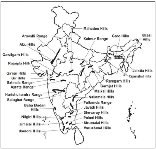
The Aravali Range
- Location: It is a residual mountain running in a northeast-to-southwest direction for about 800 km between Delhi and Palanpur in Gujarat.
- Its northeastern end is marked by the Delhi Ridge.
- Formation: The Aravalis are remnants of one of the oldest fold mountains in the world.
- Elevation: The general elevation of this mountain range is only 400 – 600 m.
- Prominent Peaks: Mount Abu (1158 m), Guru Shikhar (1722 m – the highest peak of the Aravalis), etc.
The Vindhyan Range
- Location: It lies to the south of the Malwa Plateau and runs parallel to the Narmada Valley in the east-west direction
- It stretches for a distance of over 1200 km from Jobat in Gujarat to Sasaram in Bihar.
- This range, lying in the region of the Peninsular Plateau of India, forms the northern border of the Deccan and serves as the watershed between the Ganga and South Indian River systems.
- Formation: They are considered a Block Mountain as they have been formed through cracks in the Earth’s crust.
- Elevation: The general elevation of this range is 300-650 m.
- Composition: It comprises horizontally bedded ancient sedimentary rocks with its western part covered with lava.
- Rivers: The area is drained by several rivers, including the Betwa, Ken, and Chambal.
- Ranges: These mountains continue eastward into two branches:
The Kaimur Range
- It is the northern branch that runs north of the Son River upto western Bihar.
The Bharner Hills
- It is the southern branch, running between the upper reaches of the Son and Narmada rivers to meet the Satpura Range.
The Satpura Range
- About: It is a series of seven Block Mountains, thus justifying its name Satpura
- In Sanskrit, ‘Sat’ means seven, and ‘Pura’ means mountains).
- Location: It lies in the region of the Peninsular Plateau of India and is located to the south of the Vindhyan Range and stretches in an east-west direction between the Narmada and the Tapi.
- It starts from the Rajpipla Hills in the west and continues for a distance of around 900 km through the Mahadev Hills to the Maikala Range.
- Rivers: The Satpura Range is drained by many rivers, including the Narmada, Wainganga, Wardha and Tapi.
- Important Peaks: Dhupgarh (1350 m) near Pachmarhi on Mahadev hills is the highest peak.
- The other peaks are Astamba Dongar (1325 m) and Amarkantak (1127 m).
The Western Ghats (or the Sahyadris)
- About: The Western Ghats, also known as the Sahyadris, refer to the mountain range that runs parallel to the western coast of the Peninsular Plateau of India.
- Location: To the east of this mountain range lies the Deccan plateau and to the west lies the Coastal Plains and the Arabian Sea.
- North-South Extent: It runs parallel to and near the coast of the Arabian Sea, from the Tapi Valley to a point north of Kanyakumari.
- It spreads over the States of Gujarat, Maharashtra, Goa, Karnataka, Kerala, and Tamil Nadu as well as two UTs namely Dadra & Nagar Haveli and Puducherry (Mahe).
- Topography: They are characterized by steep-sided, terraced, flat-topped hills or cliffs, presenting a mesa-like stepped topography.
- Slope: On the western side, the Western Ghats rise abruptly from the Western Coastal Plain. However, on the eastern side, they slope gently.
- Divisions: The Western Ghats can be divided into three sections – the Northern Section, Middle Sahyadris, and Southern Section.
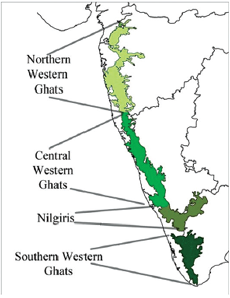
The Northern Western Ghats (The Northern Sahyadri)
- Location: This section of the Western Ghats is located between the Tapi Valley to a little north of Goa.
- Composition: It is composed of horizontal sheets of Deccan lavas forming an imposing wall along the western coastal plains.
- Important Peaks: Kalsubai (1646 m), Salher (1,567 m), Mahabaleshwar (1438 m) and Harishchandragarh (1424 m).
- Important Passes: Thalghat and Bhorghat.
- They provide passage between the Western Coastal Plain and the Deccan Plateau
The Central Western Ghats (The Central Sahyadri)
- Location: This section of the Western Ghats runs from 16°N latitude up to the Nilgiri Hills.
- Composition: This part is made up of granites and gneisses.
- Important Peaks: Doddabetta (2637 m), Makurti (2554 m), Vavul Mala (2,339 m), the Kudremukh (1892 m) and Pushpagiri (1714 m).
The Southern Western Ghats (The Southern Sahyadris)
- Location: This section forms the southernmost division of the Western Ghats.
- The southern part of the Western Ghats is separated from the main Sahyadri Range by a mountain pass called the Palghat Gap.
- Important Peaks: Anai Mudi (2,695 m) is the highest peak in the peninsular plateau region as well as the whole of southern India.
- Important Hills: Prominent hills lying in this section are discussed as follows.
- From the Anai Mudi Peak, three ranges radiate in different directions:
The Anaimalai Hills
The Anaimalai Hills (1800-2000 m) run from the Anai Mudi Peak towards the north
The Palni Hills
The Palni Hills (900-1200 m) run from the Anai Mudi Peak towards the northeast
The Cardamom Hills
The Cardamon Hills (1000-1500 m), also known as the Ealaimalai Hills, run from the Anai Mudi Peak towards the south
- Other hills located in this section are
Agasthyamalai Hills
- Agasthyamali Hills (1,868 m), well known for its endemic components, is situated at the southern end of Western Ghats.
The Eastern Ghats
- About: The Eastern Ghats refers to a series of discontinuous ranges of mountains that border the eastern edge of the Indian Peninsular Plateau, and run almost parallel to the east coast of India.
- Location: To the west of this mountain range lies the Deccan Plateau and to the east lies the Coastal Plains and the Bay of Bengal.
- North-South Extent: They stretch from the Mahanadi in Odisha to the Vagai in Tamil Nadu.
- Topography: Unlike the Western Ghats, the Eastern Ghats are not a continuous range. They comprise a chain of highly broken and detached hills.
- Divisions: The Eastern Ghats can be divided into two sections:
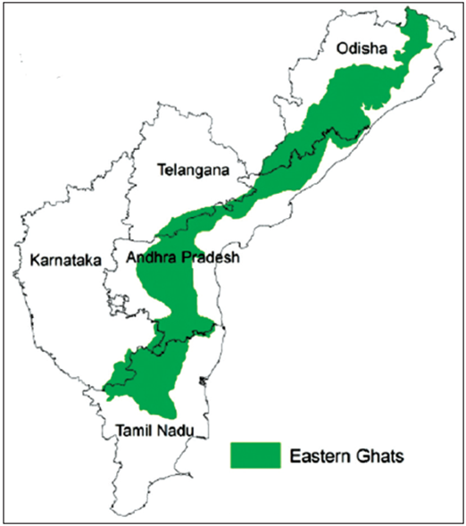
The Northern Eastern Ghats
- Location: This section of the Eastern Ghats lies between the Mahanadi and the Godavari Valley.
- Important Hills: Some of the important hill ranges lying in this part are:
Maliya Range
Mahendra Giri (1501 m) is the tallest peak in this range.
Madugula Range
Some important peaks in this range are – Arma Konda (1680 m), Gali Konda (1643 m), Sinkram Gutta (1,620 m), etc.
The Southern Eastern Ghats
- Location: This section of the Eastern Ghats lies between the Godavari and the Krishna rivers.
- Important Hills: Some of the important hill ranges in this part include:
The Nallamalai Range
The southern part of the Nallamalai Range is called the Palkonda Range.
Javadi Hills
These hills are located in northern Tamil Nadu.
Shevroy-Kalrayan Hills
These hills are also located in Tamil Nadu.
Biligiri Rangan Hills
These hills are situated at the border of Karnataka and Tamil Nadu.
- At its southern extremities, the Eastern Ghats merge with the Western Ghats.
Significance of the Oldest Landmass of Indian Subcontinent
As the oldest and the most stable landmass of the Indian subcontinent, the Peninsular Plateau of India carries many significances:
- Mineral resources: The plateau is blessed with large quantities of mineral resources like Iron, Copper, Manganese, Bauxite, Chromium, Mica, Gold, etc.
- Coal deposits: The region contains 98 percent of the Gondwana coal deposits in the country.
- Agriculture: The region is covered with black soil which is found suitable for the production of several crops such as cotton, tea, coffee, rubber, millet, etc.
- Forest produce: Being replete with forest these areas are an abundant source of forest produce like timber, etc.
- Rivers: The rivers in these areas offer great opportunities for the generation of hydroelectricity and provide irrigation facilities for crops.
- Tourism: The place has numerous places of scenic beauty such as Ooty, Pachmarhi, Kodaikanal, Mahabaleshwar, Mount Abu, etc.
Much more than just a geographical feature,the Peninsular Plateau of India carries multiple significance. This largest physiographic division of India is a source of multiple resources. Of late, it faces several challenges, including deforestation, soil degradation, and loss of biodiversity. Understanding and preserving this unique landform is crucial for ensuring the ecological balance and sustainable development of the region.
FAQs about the Indian Peninsular Plateau
What is the Peninsular Plateau?
The Peninsular Plateau of India is a flat tableland lying in the southern part of India and is surrounded by oceans on three sides. It is also known as the Indian Peninsular Plateau.
Where is the Peninsular Plateau located?
The Peninsular Plateau of India is located in the southern part of the country.
Which is the oldest plateau in India?
The Deccan Plateau is considered to be the oldest plateau in India. It forms a part of the Peninsular Plateau of India, which, in itself, is considered to be the oldest landmass in India.
Name the major physical divisions of India.
India’s major physical divisions include the Northern Mountains, the Northern Plains, the Peninsular Plateau, the Indian Desert, the Coastal Plains, and the Islands.
Mention the names of the two important plateaus in India.
The two important plateaus in India are the Deccan Plateau and the Chota Nagpur Plateau.
Which plateau is located to the south of the Great Plains of India?
The Peninsular Plateau is located to the south of the Great Plains of India.
What is Peninsular Plateau?
The Peninsular Plateau is a triangular-shaped landmass in India, also known as the oldest landmass of the country, consisting of flat-topped hills, valleys, and extensive plains.
How was the Peninsular Plateau formed?
The Peninsular Plateau was formed as a result of the drifting of the Gondwana landmass and is considered one of the most stable geological regions in India.
Mention the important historical places located in the Peninsular Plateau.
Some important historical places in the Peninsular Plateau include Hampi, Badami, Aihole, Ellora Caves, Ajanta Caves, and Khajuraho.
What is the other name of the Peninsular Plateau?
The Peninsular Plateau is also known as the “Deccan Plateau.”
Which is the oldest landmass of India?
The Peninsular Plateau, also known as the Deccan Plateau, is the oldest landmass of India.


