The coastal plains of India extend approximately 6150 kilometres along its mainland. They are split into two distinct regions called the Western Coastal Plains and the Eastern Coastal Plains, which connect the Deccan Plateau to the ocean. The Western Coastal Plain (Arabian Sea) consists of three regions, which include narrow submergent areas that extend between Konkan and Kanara and Malabar regions. The Eastern Coastal Plain (Bay of Bengal) extends over a larger area of land, which rises above the sea level and features fertile deltas that develop from rivers such as the Mahanadi, Godavari, Krishna, and Cauvery.
Some of the features of western coastal plains are the “kayals” of Kerala: The Malabar Coast is famous for its backwaters, or Kayals. These are shallow lagoons used for the world-famous Vallam Kali (Snake Boat Race) and for the eastern coast famous for the world’s nesting ground: The Odisha coast (Gahirmatha) is the world’s largest nesting beach for olive ridley turtles. And India’s largest lagoon, Chilika Lake, is a massive brackish water lagoon that hosts over a million migratory birds and the rare Irrawaddy dolphins.
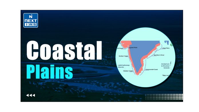
About Coastal Plains of India
The Coastal Plains of India refers to the stretch of narrow coastal strip lying between the edges of the Peninsular Plateau and the coastline of India. They constitute one of the 5 physiographic divisions of India. These plains stretch for a distance of about 6000 km along the Arabian Sea in the west and the Bay of Bengal in the east.
Divisions of the Indian Coastal Plains
- The Coastal Plains of India have been divided into two parts:
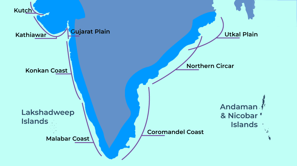
- The Western Coastal Plains of India
- The Eastern Coastal Plains of India
- The two parts of the coastal plains meet at the southernmost tip of India – Kanyakumari.
- These two parts have been further subdivided into various sub-parts as discussed in the sections that follow.
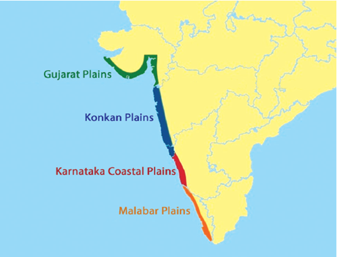
The Western Coastal Plains of India
- Location: They lie between the Western Ghats and the Arabian Sea coast.
- Spread: They stretch from the Rann of Kutch in the north to Kanyakumari in the south.
- States Covered: These plains begin in the state of Gujarat and stretch through Maharashtra, Goa, and Karnataka upto Kerala.
- Width: With an average width of about 65 km, they are quite narrow in the middle and a bit broader in the northern and southern parts.
- Nature: They are an example of a Submergent Coastline, thus providing natural conditions for the development of ports.
Sub-Divisions of Western Coastal Plains
Based on the relief and structure, these can be divided into the following subdivisions:
The Kutch Peninsula
- Location: It spreads over northwestern Gujarat.
- Formation: It was, originally, an island surrounded by seas and lagoons. The surrounding seas and lagoons, later on, got filled by deposition of sediment by the Indus River which used to flow through this area. In this way, the islands became a part of the mainland.
- Topography: The area has an arid and semi-arid landscape because of the scarcity of rain and the work of wind.
- Chief physiographic features of this region include coastal sand dunes, and sandy plains, which are interspaced with bare rocky hills.
- Extensions: In the north and south-east, it is bounded by two salt-soaked plains as described below:
The Great Rann
- It is a salt-soaked plain lying all along the north of Kutch.
- It is almost completely flat and rises only a few meters above sea level.
- It is flooded by the Banas and the Luni rivers during the rainy season.
The Little Rann
- It is the southern continuation of the Great Rann.
- It lies on the coast and to the south-east of Kutch.
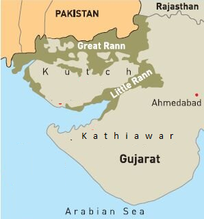
The Kathiawar Peninsula
- Location: It lies to the south of the Kutch Peninsula.
- It is surrounded by the Little Rann on the eastern side and the Nal Basin on the northeastern side.
- Prominent Hills: This region consists of some prominent hills as mentioned below:
- Mandav Hills: They lie in the central part of the Kathiawar Peninsula.
- Many small streams radiate in all directions from the Mandab Hills.
- Mandav Hills: They lie in the central part of the Kathiawar Peninsula.
- Girnar Hills: With an average height of around 1,117 m, Girnar Hills form the highest point in the region.
- Gir Range: It lies in the southern part of the Kathiawar Peninsula.
- This range is famous as the abode of the Gir Lion.
The Gujarat Plain
- Location: It lies to the east of the Kutch and Kathiawar Peninsulas and spreads over the southern part of Gujarat and the coastal areas of the Gulf of Khambhat.
- Formation: This plain has been formed by depositions of rivers like Narmada, Tapi, Mahi, and Sabarmati.
- Slope: Its average slope is towards the west and southwest.
- Elevation: It is of low elevation with none of its parts exceeding 150 m in height.
- Topography: The topography of this plain can be divided into two parts:
- The Eastern Part: This part is composed of sediments, and hence is fertile and suitable for agriculture.
- The Coastal Part: This part is covered by wind-blown loess (heaps of sand), which has given rise to a semi-arid landscape.
The Konkan Plain
- Location: This plain lies to the south of the Gujarat plain.
- Spread: It extends from Daman to Goa for a distance of about 500 km.
- Width: Its average width varies from 50-80 km.
- Topography: It has some characteristics of marine erosion including cliffs, shoals, reefs, and islands in the Arabian Sea.
- Mumbai, situated in this plain, was initially an island reclaimed to connect it with the mainland.
- The Konkan coast has a series of small bays and beaches.
The Karnataka Coastal Plain
- Location: This plain lies to the south of the Konkan plain.
- Spread: It is about 225 km long, extending from Goa to Mangalore.
- Width: It is a narrow plain with an average width of 30-50 km, the maximum being 70 km near Mangalore.
- Topography: The diverse topography of this plain can be seen as follows:
- In the central part, numerous spurs (lateral ridges of land), descending from the Western Ghats, cross the plain. These spurs go very close to the coast, thus reducing the width of the plain in this part.
- In some places, the streams originating in the Western Ghats descend along steep slopes and make waterfalls.
- For example, the
- while descending over the slope forms the Jog Falls – one of the highest waterfalls in the world.
- In the coastal parts, marine topography forms the prominent features.
The Kerala Plain
- Nomenclature: It is also known as the Malabar Plain.
- Location: It is situated between Mangalore and Kanyakumari, stretching for a distance of around 500 km.
- Width: This plain is much wider than the Karnataka Plain.
- Elevation: It is a low-lying plain.
- Topography: The presence of lakes, lagoons, backwaters, spits, etc. is the chief characteristic of this plain.
- The backwaters of Kerala are known as Kayals, which are the shallow lagoons or inlets of the sea running parallel to the coastline.
- Vembanad Lake, one of the Ramsar Wetlands, is the largest backwater with a length of 75 km and a width of 5-10 km.
The Eastern Coastal Plains of India
- Location: It is situated between the Eastern Ghats and the Bay of Bengal.
- Its discontinuous is a discontinuous line of the Eastern Ghats.
- Spread: It extends from the Subarnarekha River along the West Bengal-Odisha border to Kanyakumari.
- Width: Their average width is around 120 km, although they may be as wide as 200 km in the deltaic regions and as narrow as 35 km in between the deltas.
- Overall, they are wider in comparison to the Western Coastal Plains.
- Formation: It has been formed as a result of the alluvial fillings by the Rivers Mahanadi, Godavari Krishna, and Cauvery. Thus, it also contains some large deltas.
- Nature: They are an example of an Emergent Coastline, thus NOT providing natural conditions for the development of ports.
Nomenclature
It is known by different names in different regions:
Northern Circars
The section of the Eastern Coastal Plains lying between the Mahanadi and the Krishna rivers is known as the Northern Circars.
Carnatic
The section of the Eastern Coastal Plains lying between the Krishna and the Cauvery rivers is known as the Carnatic.
Sub-Divisons of Eastern Coastal Plains
Based on the relief and structure, these can be divided into the following subdivisions:
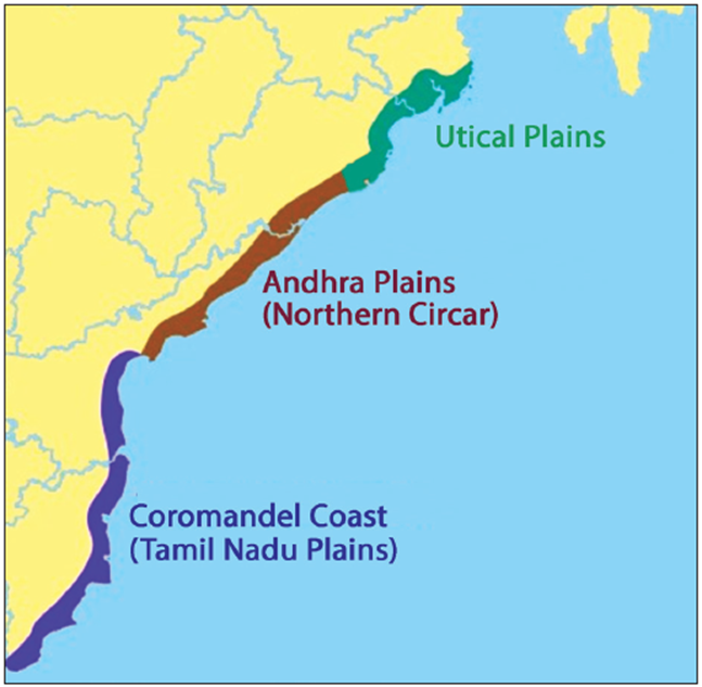
The Utkal Plain
- The Utkal Plain comprises the coastal region of Odisha, including the Mahanadi Delta.
- The famous Chilka Lake is located in this region.
The Andhra Plain
- It is located south of the Utkal Plain and extends up to Pulicat Lake.
- The chief characteristic of this plain is the delta formation by the Rivers Godavari and Krishna.
- This part is, largely, a straight coast and lacks any significant indentations. This makes the development of ports in this part very difficult.
- However, there are some prominent ports in this part, such as Visakhapatnam, Machilipatnam etc.
The Tamil Nadu Plain
- It stretches for a distance of around 675 km from Pulicat Lake to Kanyakumari along the coast of Tamil Nadu.
- The most important feature of this plain is the Cauvery Delta where the plain is 130 km wide.
- The fertile soil and large-scale irrigation facilities have made the Cauvery Delta the granary of South India.
Difference between Eastern and Western Coastal Plains
| The Western Coastal Plains | The Eastern Coastal Plains |
|---|---|
| Narrower | Wider |
| Intersected by various mountains of Western ghats. | Run continuously from north to south. |
| Rivers form estuaries. | Rivers form wide deltas. |
| Favors the formation of harbors. | Do not favor the formation of harbors as they have wide continental shelves. |
| Receives a high amount of rain from southwest monsoons. | Receives rains from both northeast and southwest monsoons. |
| Largely rocky. However, there are estuaries on the Konkan coast and back-waters on the Malabar coast. | Mostly sandy and have sand dunes and lagoons. |
Key Significance
The significance or the importance of coastal plains of India are categorised under the following heads:
- Agriculture: These coastal plains are covered by fertile soil, and hence are agriculturally very productive.
- Port: The entire length of the coast is dotted with big and small ports which help carry out trade.
- About 98% of India’s international trade is carried through these ports.
- Economic Resource: The coastal plains are sources of salt, monazites, mineral oils, and gas as well as centers of fisheries.
- Human Settlements: These coastal plains are home to dense human settlements and have some of the largest cities in India.
Much more than just a geographical feature, the Coastal Plains of India carry multiple significance. Apart from providing the ports, they are a source of many other resources. Of late, they are facing the risk of inundation due to global warming and the probable rise in sea level. Ensuring the sustainability of the coastal plains is not just crucial for India but for the marine ecology of the subcontinent. Sustainable development is the way forward.
FAQs about Coastal Plains
What are the coastal plains of India?
It is a narrow strip of land lying along the coastlines of India.
Where is the coastal plains located?
The Coastal Plains of India lie between the edges of the Peninsular Plateau and the coastline of India and stretch along the Arabian Sea in the west and the Bay of Bengal in the east.
Why are the coastal plains important?
As a crucial interface between land and sea, these plains are a source of multiple natural resources along with being home to India’s major ports.
What is the extent of the eastern coastal plains of India?
It extends from the Subarnarekha River to Kanyakumari.
What is the extent of India’s western coastal plains?
They extend from the Rann of Kutch in the north to Kanyakumari in the south.
What is the meeting point of the eastern and western coastal plains of India?
The two parts of the coastal plains meet near Kanyakumari.
What is the northern Circar?
The Northern Circar refers to the section of the Eastern Coastal Plains which lie between the Mahanadi and the Krishna rivers.
Which coastal plain is the rice bowl of India?
The part of the Eastern Coastal Plain lying in the Krishna-Godavari Delta Region is called as Rice Bowl of India.
What is an emergent coast?
An emergent coast Narrow sandy beaches, high cliffs, and crumbling coastlines are characteristics of emergent coasts (West Coast).


