Air masses are large bodies of air with uniform temperature, humidity, and pressure, formed over specific regions. Fronts occur when two different air masses meet, creating boundaries that influence weather patterns. These interactions often result in precipitation, storms, or temperature changes, playing a critical role in atmospheric dynamics.
About the Air Mass and Fronts
- Air masses are vast volumes of air with consistent temperature, humidity, and pressure characteristics, acquired from their source regions, such as polar, tropical, continental, or maritime areas.
- These air masses move and interact with others, shaping weather patterns globally. When two contrasting air masses meet, they form boundaries called fronts.
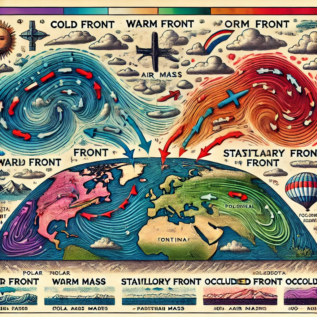
- Fronts are categorized based on the type of air masses involved and their movement. A cold front forms when cold air displaces warm air, often causing thunderstorms or heavy rain.
- A warm front occurs when warm air overtakes cold air, leading to prolonged, lighter precipitation. A stationary front arises when neither air mass dominates, resulting in extended periods of clouds and rain. An occluded front happens when a cold front overtakes a warm front.
- These interactions between air masses and fronts significantly influence local and global weather, creating dynamic conditions essential for understanding meteorology.
Types of Air Mass and Fronts
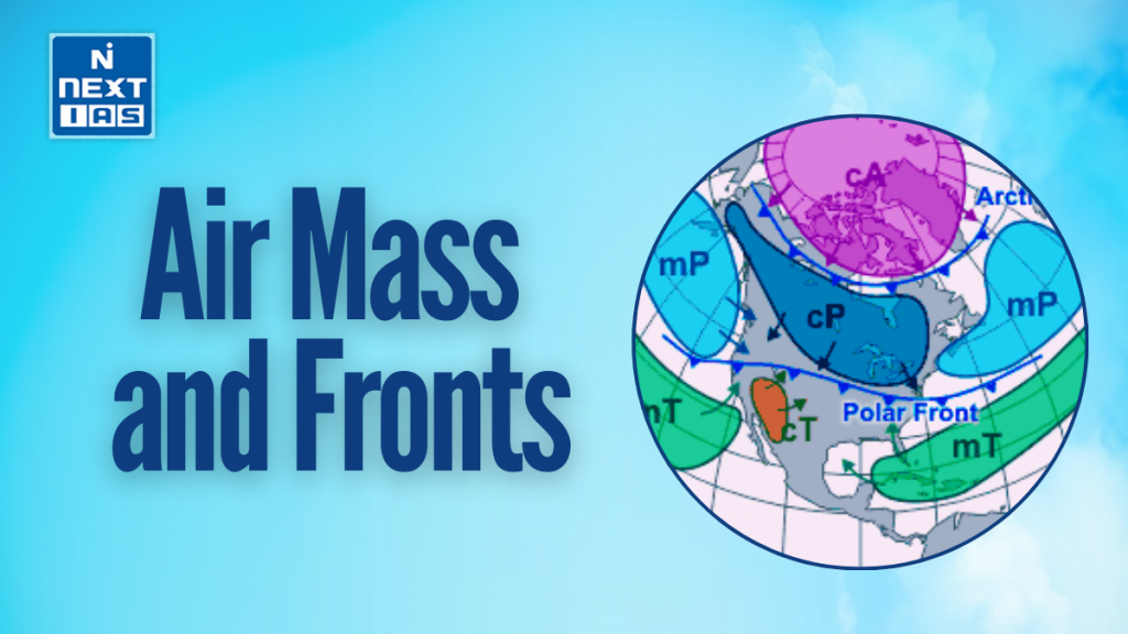
Types of Air Masses
Air masses are classified based on their source region’s temperature and moisture content:
- Tropical (T): Warm air masses originating from low latitudes.
- Polar (P): Cold air masses formed in high-latitude regions.
- Arctic (A): Extremely cold air masses originating near the poles.
- Continental (c): Dry air masses formed over land.
- Maritime (m): Moist air masses originating over oceans.
Common combinations include:
- cT (Continental Tropical): Hot and dry, formed over deserts.
- mT (Maritime Tropical): Warm and humid, from tropical oceans.
- cP (Continental Polar): Cold and dry, from high-latitude land areas.
- mP (Maritime Polar): Cold and moist, from cold oceans.
Types of Fronts
Fronts are boundaries between different air masses:
- Cold Front: Cold air pushes under warm air, causing thunderstorms and cooler weather.
- Warm Front: Warm air rises over cold air, leading to light rain and warmer temperatures.
- Stationary Front: Neither air mass dominates, causing prolonged cloudy or rainy conditions.
- Occluded Front: A cold front overtakes a warm front, often bringing complex weather patterns.
These systems significantly influence local and global weather dynamics.
Classification of Air Mass and Fronts
Classification of Air Masses
Air masses are classified based on their source regions and the characteristics of the underlying surface. They are divided into the following categories:
- By Source Region:
- Polar (P): Cold air masses from high latitudes.
- Tropical (T): Warm air masses from low latitudes.
- By Surface Type:
- Continental (c): Dry air masses that form over land.
- Maritime (m): Moist air masses that form over oceans.
Combined Classifications:
- cP (Continental Polar): Cold and dry, originates over land in polar regions.
- mP (Maritime Polar): Cold and moist, forms over polar oceans.
- cT (Continental Tropical): Warm and dry, develops over deserts.
- mT (Maritime Tropical): Warm and moist, forms over tropical oceans.
Classification of Fronts
Fronts are the boundaries between two different air masses. They are classified as:
- Cold Front:
- A mass of cold air advancing and displacing warm air.
- Often causes heavy rain or thunderstorms.
- Warm Front:
- A mass of warm air overtaking cold air.
- Associated with steady rain and warmer temperatures.
- Stationary Front:
- A boundary where neither air mass dominates.
- Results in prolonged cloudy skies and light rain.
- Occluded Front:
- Occurs when a cold front overtakes a warm front.
- Creates complex weather patterns with mixed precipitation.
These classifications are essential for understanding and predicting weather patterns.
Formation of Air Mass and Fronts
Formation of Air Masses
Air masses are formed when large volumes of air remain stationary over a specific region for an extended period, acquiring the temperature, humidity, and pressure characteristics of that area. The regions where air masses form are called source regions, typically large, uniform areas such as oceans, deserts, or polar regions.
- Tropical air masses form over warm regions, leading to high temperatures.
- Polar air masses originate in colder areas, resulting in low temperatures.
- Maritime air masses develop over oceans, being moist.
- Continental air masses form over land, making them dry.
Formation of Fronts
Fronts are boundaries formed when two different air masses with distinct temperature, pressure, and humidity meet but do not mix immediately.
- Cold Front: Created when cold air advances, forcing warm air upwards.
- Warm Front: Forms when warm air moves over cold air.
- Stationary Front: Occurs when neither air mass dominates, and they remain static.
- Occluded Front: Forms when a cold front overtakes a warm front, lifting warm air completely.
These processes drive dynamic weather changes globally.
Significance of Air Mass and Fronts
The significance of air masses and fronts lies in their profound influence on weather patterns and climate. Here are key points:
- Weather Formation: Air masses determine temperature and humidity in a region, while fronts trigger weather changes such as rain, storms, or snow when differing air masses collide.
- Climate Patterns: Air masses, originating from specific regions (polar, tropical, maritime, or continental), influence long-term climate characteristics of those areas.
- Precipitation Distribution: Fronts create precipitation patterns, with cold fronts causing heavy, short-lived rain and warm fronts leading to prolonged, lighter rainfall.
- Severe Weather: Interactions at fronts often lead to thunderstorms, tornadoes, or hurricanes, particularly in regions where air masses of starkly different properties meet.
- Agriculture and Ecosystems: Understanding air masses and fronts helps predict weather, aiding agriculture and preserving ecosystems.
Overall, they are essential for understanding atmospheric dynamics, forecasting weather, and mitigating natural disasters.
Way Forward
To better understand air masses and fronts, advanced research, real-time monitoring, and improved forecasting technologies are essential. Integrating satellite data, AI, and climate models can enhance predictions. Public awareness and preparedness strategies will help mitigate the impacts of extreme weather events caused by interactions between air masses and fronts.
Conclusion
Air masses and fronts play a pivotal role in shaping weather and climate, driving temperature changes, precipitation, and severe weather events. Understanding their dynamics is essential for accurate weather forecasting, disaster preparedness, and environmental management, helping us adapt to and mitigate the impacts of changing atmospheric conditions on daily life.
GS - 3


