Earthquake in Assam

    0
    968

    In News

    Recently, earthquakes of various magnitudes have hit Assam.

    Major Highlights

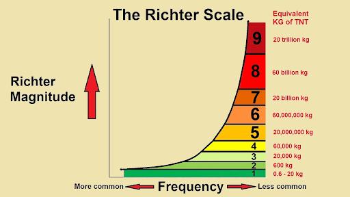
    • The main tremor had a magnitude of 6.4 on the Richter scale and other shocks ranged from 3.2 to 4.7.
    • The preliminary analysis shows that the events are located near to Kopili Fault closer to Himalayan Frontal Thrust (HFT).
      • The Kopili Fault is a 300-km northwest-southeast trending fault from the Bhutan Himalaya to the Burmese arc.
        • Fault is a fracture along which the blocks of crust on either side have moved relative to one another parallel to the fracture.
        • When an earthquake occurs on one of these faults, the rock on one side of the fault slips with respect to the other, which can be vertical, horizontal, or at some angle to the surface of the earth.

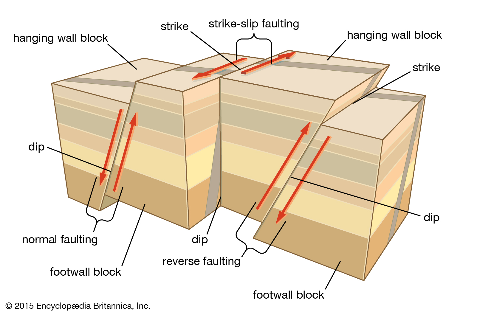
    (Image Courtesy: Britannica)


    • HFT, also known as the Main Frontal Thrust (MFT), is a geological fault along the boundary of the Indian and Eurasian tectonic plates.
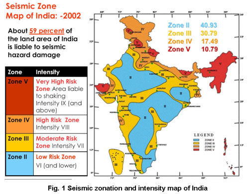
    • The area is seismically very active and falls in the highest Seismic Hazard zone V and is associated with collisional tectonics where Indian plate subducts beneath the Eurasian Plate.
    • The Northeast is located in the highest seismological zone because continuous tectonic stress keeps building up particularly along the faultlines.
      • The region has seen several moderate to large earthquakes and the worst of them was the great Assam-Tibet Earthquake (magnitude of 8.6) that occurred on Independence Day in 1950.


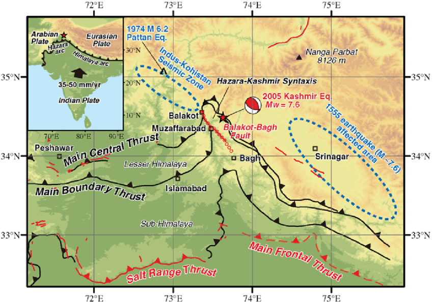
    (Image Courtesy: RG)

    Earthquake

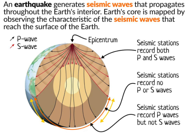
    • It is the shaking of the surface of the Earth which results in a sudden release of energy in the Earth’s lithosphere (rocky outer part of the Earth) that creates seismic waves.
    • They are caused by the slow deformation of the outer, brittle portions of tectonic plates, the earth’s outermost layer of crust and upper mantle.
    • Due to the heating and cooling of the rock below these plates, the resulting convection causes the adjacently overlying plates to move or deform (under great stress).
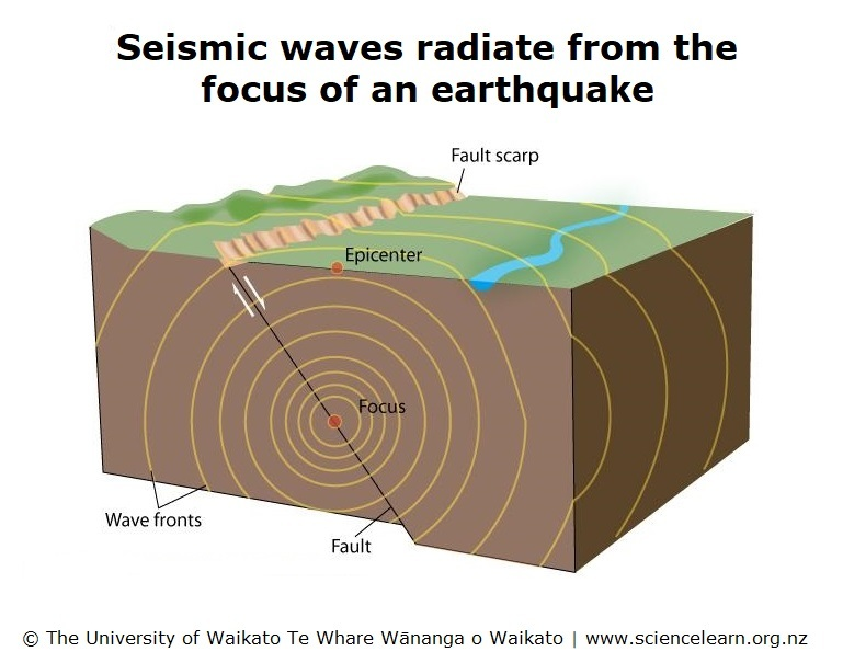
    • An earthquake’s point of initial rupture is called its hypocenter or focus. The epicentre is the point at ground level directly above the hypocenter.
    • It is measured in Richter scale.


    (Image Courtesy: YT)

    (Image Courtesy: FE)
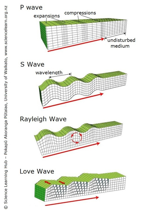
    Seismic Waves

    • When an earthquake occurs, the shockwaves of released energy that shake the Earth and temporarily turn soft deposits are called seismic waves.
    • The term comes from the Greek ‘seismos’ meaning ‘earthquake’.
    • These are usually generated by movements of the Earth’s tectonic plates but may also be caused by explosions, volcanoes and landslides.
    • Seismologists use seismographs to record the amount of time it takes seismic waves to travel through different layers of the Earth.
    • There are three basic types of seismic waves: P-waves, S-waves and Surface waves (Rayleigh and Love waves). P-waves and S-waves are sometimes collectively called Body Waves.
      • P-waves
        • These are also known as primary waves or pressure waves and travel at the greatest velocity through the Earth.
        • When they travel through air, they take the form of sound waves. They travel at the speed of sound (330 ms-1) through air but may travel at 5000 ms-1 in granite.
        • Due to their speed, they are the first waves to be recorded by a seismograph during an earthquake.
        • They differ from S-waves in that they propagate through a material by alternately compressing and expanding the medium, where particle motion is parallel to the direction of wave propagation.
      • S-waves
        • These are also known as secondary waves, shear waves or shaking waves.
        • These are transverse waves that travel slower than P-waves and particle motion is perpendicular to the direction of wave propagation.
        • S-waves cannot travel through air or water but are more destructive than P-waves because of their larger amplitudes.
      • Surface Waves
        • Surface waves are similar in nature to water waves and travel just under the Earth’s surface.
        • They are typically generated when the source of the earthquake is close to the Earth’s surface. Although surface waves travel more slowly than S-waves, they can be much larger in amplitude and can be the most destructive type of seismic wave.
        • Rayleigh Waves: Also called ground roll, travel as ripples similar to those on the surface of water.
        • Love Waves: These cause horizontal shearing of the ground. They usually travel slightly faster than Rayleigh waves.

    (Image Courtesy: SLH)

    Indian Seismic Zones

    • Earthquake-prone areas of India have been identified on the basis of 3 factors, namely
      • Scientific inputs related to seismicity.
      • Earthquakes occurred in the past.
      • Tectonic setup of the region.
    • Based on these conditions, the Bureau of Indian Standards (BIS) divided the country into four seismic zones, viz. Zone II, Zone III, Zone IV and Zone V.

    (Image Courtesy: NIDM)

    Source: IE