


Syllabus: GS1/Geography GS2/International Relations
Context
- A devastating glacial collapse and flash floods near the Nepal-China border have renewed concerns over China’s mega-dam on the Yarlung Zangbo, particularly downstream countries like India and Bangladesh.
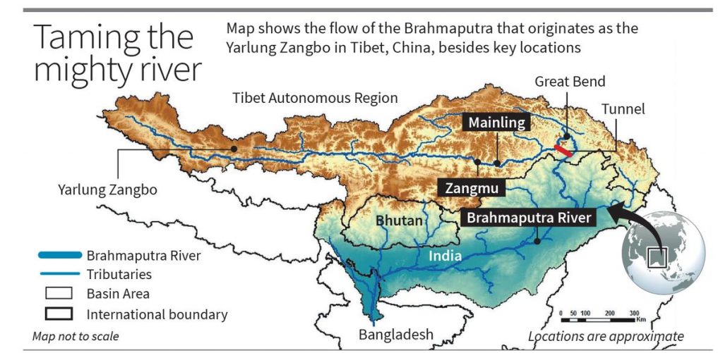
Scale and Engineering
- The project is located near the dramatic ‘Great Bend’, where the Yarlung Zangbo (Brahmaputra in India) turns towards India. It is estimated that:
- 60 GW installed capacity
- 300 billion kWh annual generation
- More than three times the Three Gorges Dam’s generation
- The project involves a reservoir, reportedly around Mainling, upstream of Nyingchi although described as run-of-the-river.
Yarlung Tsangpo ( Zangbo) River
- It originates from Chemayungdung Glacier in Tibet, and enters Arunachal Pradesh, where it is known as the Siang.
- In Assam, it is joined by tributaries such as Dibang and Lohit, and is called the Brahmaputra.
- The river then enters Bangladesh, and makes its way to the Bay of Bengal.
- The basin spreads approximately 5,80,000 square kilometers across China (50.5%), India (33.3%), Bangladesh (8.1%) and Bhutan (7.8%).
Key Concerns of the Project
- Ecological & Environmental Concerns:
- Disaster Risk: Seismic risks as the project is in a highly earthquake prone Himalayan region.
- Climate & cascading hazards: Glacier/GLOF risks amplified by construction in fragile permafrost/steep terrain; extreme rainfall events more likely under climate change.
- Biodiversity: Yarlung Tsangpo Grand Canyon is a global hotspot, dam can impact biodiversity.
- Geopolitical Risks:
- Water control & leverage: China as upper riparian can regulate timing and volume of flow. Risk of reduced dry-season discharge or sudden releases.
- Geopolitical signalling: Project near disputed border strengthens China’s presence in a sensitive sector.
- India’s vulnerability: Brahmaputra vital for Arunachal (Siang), Assam and further downstream Bangladesh. India lacks binding water-sharing treaty.
- Competition over Water: The Brahmaputra basin involves the interests of China, India and Bangladesh. Upstream dams and diversion plans could increase tensions and affect regional water security.
India-China Cooperation
- Expert Level Mechanism (2006): Annual discussions on flood-season data and transboundary river issues.
- Brahmaputra data sharing: Covers June–October data from three Tibetan stations; the arrangement expired in 2023 and renewal is under discussion.
- Sutlej data sharing: Covers June–October data; the arrangement expired in 2020.
- Umbrella MoU (2013): Provides a broader framework for cooperation and expanded the data-sharing period.
Way Forward for India
- Strengthen India’s response: India should pursue real-time hydrological data sharing, joint disaster-warning mechanisms, seismic and environmental impact assessments, diplomatic engagement and basin-level cooperation.
- Demand transparency: Seek technical details, environmental assessments and dam-safety information from China.
- Strengthen regional cooperation: Work with downstream countries for data sharing, joint environmental assessments and disaster preparedness.
Previous article
News In Short 07-09-2026
Next article
Sustainable Cooling of Data Centres in India
