
 80813-00200



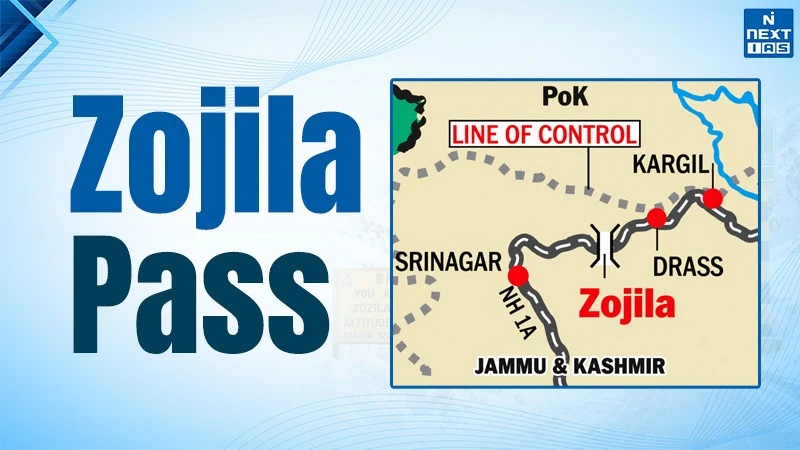
The Zojila Pass is in the Greater Himalayan Range of Kashmir and Ladakh, connects Srinagar to Dras, Kargil, and Leh via National Highway 1. It is located at an elevation of around 11,575 feet (3,528 meters). It is of utmost significance to the national security, military logistics, and trade and tourism of India. The recapture of the Zojila Pass by the Indian Army from Pakistan during the Indo-Pakistani War of 1947-48 on 1 November 1948 by Operation Bison. It was a great military feat that involved the deployment of tanks at high altitudes.
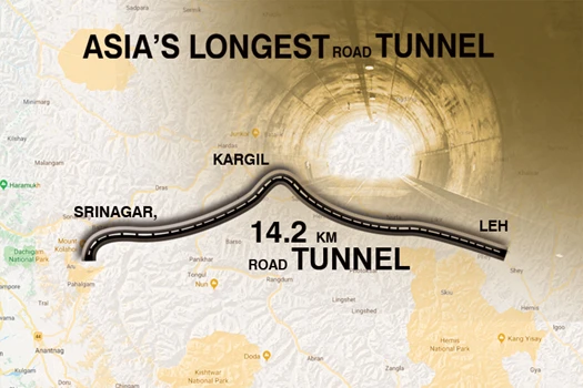
The pass is often blocked due to heavy snowfall, avalanches and landslides and hence, poses difficulty for any winter connectivity. This problem is being addressed by the construction of the Zojila Tunnel, which is of a length of 14.15 km and ensures all-season connectivity. A major breakthrough in the main tunnel of this project occurred in June 2026.
About the Zojila Pass
- Zojila Pass, one of the most critical and challenging high-altitude passes in the world located in the Ganderbal district of Jammu and Kashmir and the Kargil district of Ladakh, on National Highway 1 (NH-1) between Srinagar and Leh.
- It connects the Kashmir Valley with the Drass and Suru valleys and further with Ladakh, serving as the lifeline for the Union Territory.
- Widely known as the "Gateway to Ladakh" this mountain pass holds immense importance for national defence, regional connectivity and socio-economic integration, particularly because of its proximity to the borders with Pakistan and China.
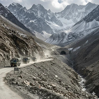
Geological Condition
- It is part of the greater Himalayas, which were formed due to collision between the Indian and Eurasian tectonic plates around 50 million years ago.
- The region marks the Mains Central Thrust (MCT) , a major geological fault line that separates the higher Himalayas Crystalline rocks from the lesser himalayan formations.
- The pass primarily comprises metamorphic rock including Gneiss and schist, and sedimentary rocks including Quartzine, slate and limestone etc.
- The terrain is young and geologically unstable due to ongoing plate tectonic movements.
- Frequent landslides, rockfalls, and avalanches are common especially during and after heavy snowfall or rain.
- Seismicity : Zojila lies in seismic zone-IV, making it a highly earthquake prone area.
Climatic Condition
- The Name Zojila refers to 'Blizzard pass', in the local language, indicating its harsh climatic conditions.
- Zojila experiences an alpine or tundra type climate, characterized by long, harsh winters and short, cool summers.
- Due to its high altitude and position between temperate Kashmir and cold desert ladakh, it serves as a climatic transition zone.
- On western side of passage occurs heavy snowfall but limited rainfall marked by lush, Green valleys, meadows, and temperate forests due to higher moisture; and on the eastern side Ladakh lies in the rain shadow zone marked by a cold, arid, mountainous desert landscape with rugged, bare mountains and scanty vegetation.
Strategical Historic Significance
- Zojila served as an ancient trade route connecting the kashmir valley with central asia through ladakh; to exchange silk, pashmina, saffron and spices, fostering cultural interaction and economic exchange.
- It gained historic prominence during the indo-pak war of 1947-48, When pakistani raiders supported by the pak army, captured Zojila.
- In november 1948, the indian army, launched operation Bison for counterattack, for the first time, tanks were used at such a high altitude, surprising the enemy and recapturing Zojila.
- Zojila pass holds enormous strategic military importance due to its proximity to Pakistan-occupied Kashmir (PAK) and Line of Actual Control (LAC) with China.
- The passage also acts as a vital logistical corridor for moving troops, weapons and supplies to the regions in drass, kargil and leh etc.
- Zojila is the merely direct surface link connecting the Kashmir valley in the western side to Ladakh in the eastern side.
- Accessibility to this passage is crucial for disaster response, civilian movement and socio-economic integration of the region.
- The Zojila pass not only provides a secure route to the Siachen glacier, but also to the world's highest battlefield, ensuring strategic access to the frontier areas of eastern Ladakh, where India and China have had multiple standoffs.
Zojila Tunnel Project
- The project involves the construction of a 14 KM long bi-directional tunnel beneath the passage.
- After completion it will reduce the time travel from 3.5 hours to about just 15 minutes
- It lies on the srinagar-kargil-leh national highway, which aims to provide all weather, round the year connectivity between kashmir valley in western himalayas and cold desert of ladakh in trans-himalayan region.
- Though, It also has its own unique challenges of freezing temperatures, lack of oxygen and frequent avalanches in the region.
- Every year during winter months, it experiences heavy snowfall, forcing its closure and then opens by the start of summer season by next year.
- The government of India launched the project in 2018, reflecting its long-standing attempt to ensure strategic, economic and humanitarian connectivity to the region.
Significance
- After completion (targeted for 2028), the Zojila tunnel will be Asia's longest bi-directional road tunnel at a very high altitude.
- This project plays a crucial role in boosting national security, regional economic development and tourism etc. by ensuring uninterrupted travel and logistic support to the region.
Safety Features
- Emergency lay-bys are located at intervals of 750 m staggered on both sides of the carriageway. There are sidewalks on both sides of the carriageway. Emergency call niches and hydrant niches are situated at intervals of 125 m.
- Manual fire alarm push buttons and portable fire extinguishers shall be at the disposal of all drivers.
- A telephone shall be installed at the emergency call niches. Fire Hydrants and Hydrant Niches, Fire Extinguishers.
-
Tunnel Lighting Systems: The Tunnel Lighting System represents the most significant part of the tunnel traffic safety and shall cover the following needs:
- Entrance lighting (in the accommodation sections at both ends of the tunnel)
- Interior lighting (through the whole tunnel)
- Lay-bys lighting
-
Video Surveillance system :
- CCTV-Cameras: The surveillance cameras in the tunnel shall be installed on the tunnel wall and the cameras in the area before and after the tunnel are installed on a pole. Data and video images shall be transmitted through the communications lines. To achieve this, transceivers and media converters shall be employed.
- Fire Alarm System in buildings, Automatic Fire Detection and suppression System.
- Linear heat detection systems shall be connected to the SCADA system through its own control system.
-
Emergency Telephone Niches
- Emergency call niches shall be located, according to the EU standard, in the tunnel at intervals of less than 125 m each to each other in the tunnel and in all lay-bys. The emergency points shall have the following equipment:
- Fire alarm push buttons
- Fire extinguishers
- Traffic control system with a central control room.
Way Forward
- The passage is more than just a route through the Himalayas; it is a symbol of national resilience, strategic foresight and developmental aspiration.
-
The project should be complete on time as its timely execution will
ensure throughout the year all- weather connectivity to the region.
- The Zojila tunnel project is aligned with India's broader strategic vision of "Viksit Bharat@2047" and the PM GATI Shakti initiative.
- The focus should also be to develop climate-resilient infrastructure, including avalanche shelters, smart weather monitoring, and slope stabilization system to minimize disruption caused by snow and landslides etc.
- To mitigate geological instability in the fragile himalayan ecosystem, eco-sensitive construction, environmental impact assessments (EIA) and green engineering practices etc should be adopted.
- Tourism, trade, and livelihood opportunities that foster regional development will help support the locals and their inclusive development.
- In other words, Zojila needs to be developed as a safe, sustainable, and socio-economically integrated corridor that reflects India's strategic foresight and commitment to inclusive Himalayan development.
FAQs about Zojila Pass
What is the elevation of Zojila pass?
Zojila pass is located at an elevation of about 3528 metres (11,575 feet) above sea level in the greater himalayan range.
Which national highway passes through Zojila?
Zojila pass lies on national highway- 1 (NH-1), connecting Srinagar to Leh through Drass and kargil.
What is the total length of the under construction Zojila tunnel?
The Zojila tunnel under construction is 14.2 km long, and upon completion, it will be Asia's longest bi-directional road tunnel at a high altitude.
