
 80813-00200



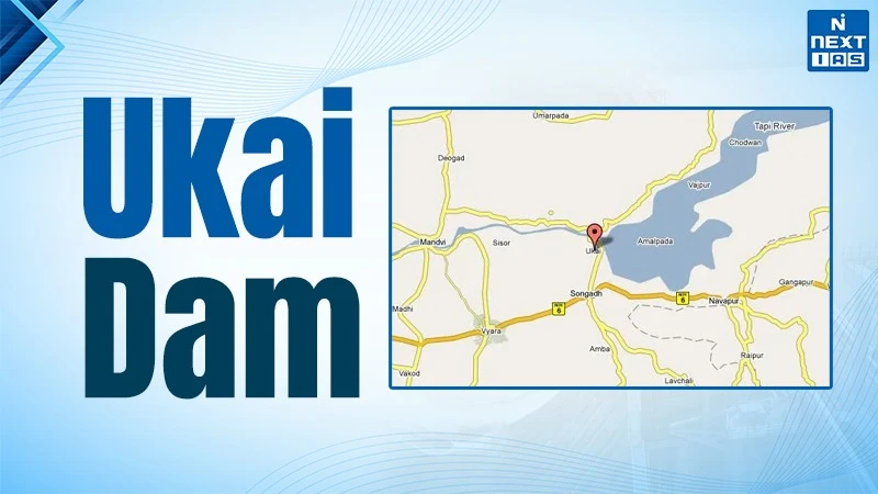
The Ukai Dam, which is also referred to as Vallabh Sagar. It is a multipurpose dam constructed on the Tapi River located near Ukai village in Tapi district (about 94 km from Surat) of Gujarat. It is constructed in 1972, this is one of the largest water storage projects in the state of Gujarat. The Ukai Dam is about 4,927 metres long, and it has a reservoir capacity of about 7,414 million cubic metres when it is filled to its full capacity.
This dam contributes in irrigation activities, hydropower production, water supply for domestic use and even flood management for downstream areas like South Gujarat. Ukai Dam has a hydroelectric power station that has 4 units of 75 MW each, giving a total of 300 MW. It regulates the flow of water in the Tapi River and thereby reduces the risk of flooding in downstream areas, such as Surat. Thus, it is considered a lifeline for agriculture in Gujarat.
About the Ukai Dam
Such projects are envisioned as instruments of agriculture growth, industrialization, flood control and regional development. After independence river valley projects played a pivotal role in development strategy.
- Reservoir name: Ukai Reservoir which is also known as the Vallabh Sagar Dam.
- Location: The reservoir is located close to Ukai village in the Tapi district of Gujarat.
- River : The dam is built on the Tapi River, which is also referred to as Tapti.
- Type of the dam : It is an earth-constructed-masonry dam with portions of masonry to make the structure stronger.
- Dimensions of the projects :
- Total length of Embankment: The total length of the dam is 4927.
- Height of earth dam: maximum height of the dam is about 80.7 m above its deepest foundation level, and the height of masonry dam is around 68.68 meters.
- Construction: The project started in 1964 and was completed in 1972.
- Storage capacity: The reservoir also provides approximately 46 per cent of the total storage capacity of all other dams in Gujarat, which is similar to the Bhakra-Nangal Dam.
- Features: Includes a large reservoir (Vallabh Sagar) and a thermal power station.
- The Tapi also known as Tapti river is the second-largest river system flowing westward in Peninsular India, often referred to as the "twin" of the Narmada.
- The Tapi river originates near Multai in the Betul district of Madhya Pradesh, being part of Satpura Range, at an elevation of 752 meters.
- The river flows westward for approximately 724 km (214 km is in Gujarat) through the states of Madhya Pradesh, Maharashtra and Gujarat.
- Mouth of the river: The Tapi empties into the Arabian Sea through the Gulf of Khambhat (Cambay) near Surat, Gujarat. It is an estuarine mouth, unlike a deltaic shape of largely east running rivers.
- Geology: The river is cut across a rift valley lying between Satpura and Ajanta ranges with black fertile alluvial geology as the dominant part of it.
Major Tributaries of Tapi River
- Left Bank: Purna (the principal tributary), Girna, Panjhra, Bori, Waghur, Nesu, Buray, Mona, and Sipna.
- Right Bank: Aner, Arunavati, Gomai, and Vaki.
Major Dams and Projects
- Ukai Dam (Gujarat): It is a large multipurpose project aimed at irrigation and power plants.
- Hathnur Dam (Maharashtra): It is part of the Upper Tapi Project.
- Kakrapar Weir (Gujarat): It is mostly used in the process of irrigation.
Significance of the Ukai Dam
The Ukai Dam’s conceptualized with multiple objectives :
- Irrigation Development : By ensuring regulated water supply to the nearby regions, the dam has enabled farmers to higher cropping intensity; and the expansion of water-intensive but remunerative crops like sugarcane and cotton, improving rural incomes.
- Hydroelectric Power Generation : The dam has installed hydropower capacity generating 300 MW of hydropower, contributing to the power grid, providing renewable and clean energy.
- Flood Control : The dam acts as a flood cushion, regulating river flow as the south Gujarat region has historically been vulnerable to the floods due to high monsoon rainfall, low laying topography and urban expansion along the Tapi river.
- Regional Economic Development: The regular water supply provides stability and impetus to the economy of the surrounding region, especially the textile industry, and develops the region into a major industrial hub.
- Urban and Industrial Water Supply: By providing essential water supply to the chemical, petrochemical industries, textiles and diamonds cutting activities, supports industrial expansion.
- It also supports major industries like NTPC, ONGC,Reliance and L&T located in its floodplain.
Contemporary Challenges
- Irregular Monsoons and Climate Change: The water storage and release system in Ukai Dam has been complicated by the changes in rainfall patterns with an increased number of intense precipitation days and a rise in the period of dry spells.
- Flood Management: The sudden discharge of water in times of heavy rain is also a threat of immense danger of a flood downstream and hence the need to have a scientifically based water-release policy.
- Siltation: Over time, the dam is subjected to the danger of siltation, which would eventually cause impairment in the functionality and storage of the dam.
- Environmental Impact: The disruption in the original river regime, the increase in the heavy-metal pollutants of the industrial and agricultural deposition and, as a result, the decrease in biodiversity of downstream ecosystems are the causes of the concern of sustainable development.
- Urban and Industrial Water Demand: South Gujarat is an area with great urban and industrial development that puts more demands on water resources and hinders its fair allocation between agricultural, industrial, and domestic requirements.
- Inter-State Water Management: It is the involvement of several states in the Tapi River basin, which introduces intractable issues in terms of sharing water and joint management.
- Resettlement and Social Issues: There are long term livelihood restoration questions about social justice for displaced communities remain unresolved.
Way Forward
- Scientific Reservoir Management: Due to modern conditions, decisions to store and release are mostly reactive. These operations can be made more deterministic by means of real-time monitoring of processes, accurate meteorological predictions and effective hydrological modelling.
- Smartening Flood Early Warning Systems: There is a need to intensify early-warnings, capacity and presence of effective protocol in dam authorities jointly coordinated with local governments to help in protecting down-stream settlements.
- Silt Management and Capacity Preservation: To avoid the overgrazing of the storage capacity of the reservoir, it is important to perform routine silt assessment, desilt maintenance procedures, and sustained treatment of the catchment-area.
- Climate- Adaptable Operation Strategy: Climatic adaptable protocols of dam- operation, must be prepared with a consideration of the hydrological extremes and future climatic changes.
- Integrated River Basin Management (IRBM): The concept of institutionalising the inter-state coordination in the basin of Tapi River will advance equitable and sustainable use of water.
- Sustainable use of Water : Efficiency in water allocation among agriculture, industry, and urban areas should be increased; and micro-irrigation and water recycling practices should be promoted.
- Ensuring Environmental Flows (E-Flows): Minimum environmental flows should be maintained to protect downstream ecosystems and biodiversity of the region.
- Social Justice and Rehabilitation: Firming livelihood-based rehabilitation, skills, and social security initiatives will increase the livelihood of displaced populations.
- Technological Modernisation: The next level of governance will be technological improvements in dam safety and functional performance in terms of unmanned aerial applications, geographic information aids, and Internet of things-based real-time observations.
FAQs about Ukai Dam
From where the Tapi river originates?
The Tapi river originates near Multai in the Betul district of Madhya Pradesh, being part of Satpura Range, at an elevation of 752 meters.
where is the Ukai Dam located?
Ukai Dam, also known as Vallabh Sagar, is a large earthen-cum-masonry dam located on the Tapti River in Tapi district, Gujarat.
