
 80813-00200



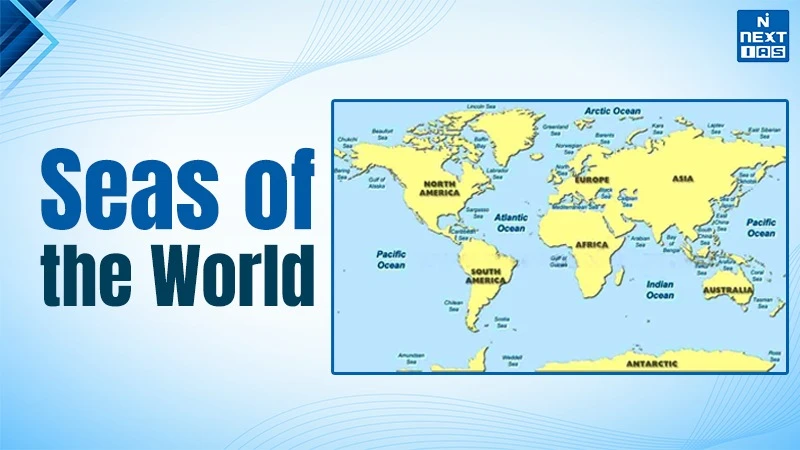
The Major Seas of the World are important parts of the global ocean system that connects continents. It supports marine biodiversity and facilitating international trade. Seas are generally smaller than oceans and are often partially enclosed by land. Some of the world's major seas include the Mediterranean Sea, located between Europe, Asia and Africa.
The Caribbean Sea, known for its tropical islands, the South China Sea, a major international shipping route. The Arabian Sea, bordering India and the Red Sea, connecting the Indian Ocean with the Mediterranean through the Suez Canal. The Coral Sea is famous for the Great Barrier Reef, while the Bering Sea lies between Asia and North America. These seas play a vital role in climate regulation, fisheries, tourism, maritime transport and the global economy.
About the Seas
- Most of the world’s seas originated through geological processes like tectonic movements, continental drift and gradual fragmentation of the ancient water bodies such as the Tethys Sea. Over millions of years, these processes shaped various seas across different parts of the world.
- Large seas like the Mediterranean Sea, South China Sea, Arabian Sea and Caribbean Sea have been essential in determining the weather of the other areas.
- They affected temperatures, rain patterns as well as helped in making monsoon and coastal weather systems, thus defining the local ecosystems and agricultural activities.
- Furthermore, most of the seas hold strategic value due to their location and connecting major sea routes linking the continents and facilitating international trade. Domination of key sea routes and passages usually dictates the geopolitical power and security in the waters.
Major Seas of the World
Mediterranean Sea
- The Mediterranean Sea is a vast inland sea which is located between Europe, Asia, and Africa. It has been a centre of the ancient civilizations cultural exchange, trade and interaction.
- It was formed as a result of the remains of the ancient Tethys Sea as a result of tectonic movements between the African plate and the Eurasian plate.
- It borders the Pacific Ocean via the Strait of Gibraltar and the Red Sea via the Suez Canal.
- It has high evaporation and very few rivers contribute to fresh water which causes its high salinity.
- With an uneven coastline numerous islands including Sicily and Crete and rivers flowing into it including the Nile River.
- It serves as a significant trade route for global trade, fisheries as well as tourism.
- Geopolitically it controls routes like the Strait of Gibraltar and the Suez Canal.
- Although it has been experiencing environmental complications such as pollution and overfishing.
Caribbean Sea
- The Caribbean Sea is a vast tropical sea of the Atlantic basin that boasts of clear waters, coral reefs, and many islands.
- It is situated between Central America, the North coast of South America, and the Caribbean Islands, and is adjacent to the Atlantic Ocean.
- It was formed as a result of the tectonic movements of the Caribbean Plate and other surrounding plates that make up deep basins and island arcs that form deep trenches such as the Cayman Trench which is the lowest point in the Caribbean.
- The climate around the area is tropical and warm in nature with constant hurricanes.
- Once It was a major region of exploration and colonial trade routes by European explorers.
- The sea serves as an important maritime route which connects Panama Canal to the Atlantic.
South China Sea
- South China Sea is a marginal sea of the western Pacific Ocean and one of the most active maritime areas in the globe joining East and Southeast Asia.
- It was formed by the tectonic movement between Eurasian Plate and Philippine Sea Plate resulting in the formation of basins and arcs of islands.
- The countries bordering it are China, Vietnam, Philippine, Malaysia and Brunei.
- It encompasses a host of reefs and islands including the Spratly Islands and Paracels Island.
- The Strait of Malacca links the Indian Ocean and the Pacific on the sea, which has been a major route of trade.
- The region is favourable for fisheries and shipping and also considered to be rich in oil and gas reserves.
- The geopolitical significance of the region is marked by the conflicts of countries over a piece of land in the territorial issues, especially between China and Philippines.
- The sea is vital in international trade with a large portion of world's shipping passing through it every year.
Arabian Sea
- The Arabian Sea, which is a significant entity of the Indian Ocean, contributes significantly to the climate of the region, trade, and maritime connectivity.
- It formed as a result of tectonic forces that were associated with the separation of the Indian plate off the African and Arabian plates millions of years ago.
- It is located between the Arabian Peninsula and the Indian Subcontinent with countries like India, Pakistan, Oman and Somalia bordering it.
- There are deep basins and significant features of the sea like the Carlsberg Ridge and the Laccadive Sea.
- It receives fresh water from major rivers such as the Indus River and Narmada river.
- The South Asian monsoon mechanism is largely affected by the Arabian sea which has a powerful impact on the rainfall patterns in India.
- In ancient times it used to be one of the main routes of ancient maritime trading between India, the Middle East, and East Africa.
- The sea sustains fisheries, oil transportation and huge seaports, including Mumbai Port. It plays a critical role in international shipping lines and energy transportation in the Persian Gulf region.
Bering Sea
- The Bering Sea is a marginal sea of the Pacific ocean, which boasts of rich marine life and viable fisheries.
- It evolved as a result of tectonic action, and creation of ocean basins between the North American plate and Eurasian plate.
- It is a stretch between Alaska and Russia with the Pacific linked to it through the Aleutian Islands.
- The ocean contains the deep basins alongside the shallow continental shelf referred to as the Bering Shelf.
- It is connected with the arctic ocean by the Bering Strait while sustaining the species of whales, seals, seabirds and high populations of fish.
- It plays a crucial role to the maritime routes and geopolitical relations between the United States and Russia.
Black Sea
- The black Sea is a large inland sea situated between Eastern Europe and Western Asia characterized by a distinct marine life as well as historical significance.
- It originated from the remains of the ancient Tethys Sea that transformed by the action of tectonic and geologic processes that have occurred over millions of years.
- It is bordered by Turkey, Ukraine, Russia, Georgia, Romania and Bulgaria.
- It is connected to the Mediterranean Sea by the Bosporus Strait and Dardanelles Strait.
- It is unique among seas because the sea contains deep waters and a large anoxic (oxygen-free) lower layer.
- Rivers like the Danube River, Dnieper River and Don River drain into it.
- It holds major geopolitical importance due to naval presence and regional conflicts involving countries like Russia and Ukraine.
Red Sea
- The Red Sea is a narrow sea situated between the Africa and Asian continent, a part of the Indian Ocean. It is known for its warm waters and rich coral reefs.
- It was formed from the rifting and separation between the African Plate and the Arabian Plate.
- It is situated between Egypt, Sudan, Saudi Arabia, and Yemen and it is linked to the Mediterranean through the Suez Canal.
- The sea is long and narrow with deep basins and high salinity as a result of high evaporation.
- It links with the gulf of Aden by Bab-el-Mandeb Strait.
- The area boasts of hot and dry climate and has very low rainfall with large coral reefs and a variety of marine life in the Red Sea.
- It was a significant route of trading between the Mediterranean and the Indian Ocean.
- It forms one of the major maritime routes between Europe and Asia along the Suez Canal.
Baltic Sea
- The Baltic Sea is a semi-enclosed sea in Northern Europe which is a significant expansion of the Atlantic Ocean.
- It came into existence after the last Ice Age when the movement of the glacial masses and the melting ice formed the basin.
- It is surrounded by Sweden, Finland, Poland, Germany and Russia.
- The water in the sea is of low salinity and relatively shallow due to great fresh water input and minimal interaction with the ocean.
- It is drained by rivers such as the Vistula and the Oder river, where several islands can be found on its coast.
- Surrounding countries are dependent on shipping, fisheries, and ports.
- It enjoys increased geopolitical significance because of regional security and energy-paths in Northern Europe.
North Sea
- The North Sea is an Atlantic Ocean marginal sea which is one of the busiest seas in Europe.
- It was primarily created following the previous ice age as a result of ice action and elevating sea levels.
- It lies between the United Kingdom and mainland Europe, neighboring Norway, Denmark, Germany, Netherlands and Belgium.
- It is fairly shallow and it has large continental shelves and sandbanks.
- It is fed by major rivers like the Rhine River and Elbe River while sustaining fisheries and shipping.
- It has major oil and gas fields and plays an pivotal role in the European energy sources, trade routes as well as offshore wind energy.
Sea of Japan
- The Sea of Japan is a Pacific Ocean marginal sea, which has deep fisheries and strategic significance in the Northeast of Asia.
- created by the tectonic movements and the division of the Japanese islands and the mainland of Asia.
- It borders Japan, South Korea, North Korea and Russia.
- The sea is also deep with few links to the Pacific via narrow straits.
- Notable straits are Tsushima Strait, and Tsugaru Strait connecting it with the neighboring seas.
- It sustains a variety of marine species and lucrative fishing areas.
- It is geopolitically significant because of the existence of the navy and geographical closeness to the Northeast Asian powers.
- Koreans refer to the sea as the East Sea, sometimes, due to the name disagreement of the area.
Bay of Bengal
- Bay of Bengal is the largest bay of the world and a significant component of the Indian Ocean which play a crucial role in the South and South East geography and climatic patterns.
- It was formed as a result of tectonic processes connected with the motion of the Indian plate and sedimentation processes throughout millions of years.
- It is adjoined with India, Bangladesh, Myanmar, and Sri Lanka.
- It has deep basins and extensive river deltas which include the Ganges-Brahmaputra Delta etc., As drained by major rivers like Ganges River, Brahmaputra River and Mahanadi River.
- The bay sustains good marine ecosystems and mangroves such as the Sundarbans.
- It has a very powerful impact on the South Asian monsoon, and often it is affected by tropical cyclones.
- Bay of Bengal is susceptible to harsher cyclones and coastal floods to the neighboring nations.
Sargasso Sea
- The sargasso sea is a unique sea in the North Atlantic Ocean that consists of floating seaweed, referred to as Sargassum and calm waters while it is the only sea without land boundaries in the world.
- It is located in the east of the United States and North of the Caribbean Sea.
- Explorers like Christopher Columbus came across it on transatlantic trips.
- It arose as a result of the patterns of ocean circulation and not land boundaries and is influenced by the ocean currents around it.
- It is located in the North Atlantic and is enclosed by currents like the Gulf stream, North Atlantic current and Canary current.
- It does not have any land boundary, as seen in most seas, and is defined by clear blue water and floating seaweed.
FAQs
What is a sea?
A sea is a large body of saltwater which is smaller than an ocean and is often partly enclosed between land masses.
What are the strategic significance of seas?
Most seas have major shipping routes and chokepoints like the Strait of Gibraltar and, therefore, are critical to international trade and security.
which sea has no land border.
The Sargasso sea is a unique sea in the world which has no land border.
