
 80813-00200


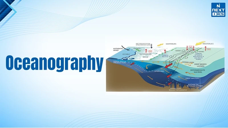
Oceanography is the scientific study of the ocean and is divided into 4 branches which are physical, chemical, biological, and geological. It includes oceanic components such as marine organisms, ocean currents, and tides. The mid-oceanic ridge is the longest mountain present on earth that stretches over 64,000 kilometres inside the oceans. The Mariana trench is situated 11 kms deep inside the ocean which is deeper than the height of Mount Everest.
The oceans cover about 70% of the Earth's surface, regulate weather phenomena, supply food and minerals. The oceans are home to a unique ecosystem ranging from small sized plankton to large whales. Interestingly, the phytoplanktons produce over 50% to 80% of the earth's oxygen. The largest waterfall in the world is the Denmark Strait Cataract which flows over 11,000 feet underwater.
National Institute of Oceanography
- Headquarters: The National Institute of Oceanography
- (NIO) was established on 1st January 1966. It is a research organization under the Council of Scientific and Industrial Research (CSIR) and is headquartered at Dona Paula in Goa.
- Regional Presence: The NIO is operational at 3 regional centres located in Mumbai, Kochi, and Visakhapatnam. These places are deliberately kept near the coastal region for offshore research in the east and west part of India.
- Advanced Fleet Capabilities: The NIO utilizes the oceanographic research vessels such as RV Sindhu Sankalp and RV Sindhu Sadhana for deep ocean exploration, mapping of resources, and climate monitoring.
Configuration or Mapping of the Ocean Floor
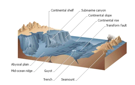
- The ocean contains a diverse range of landscapes that closely resemble those found on land, including mountains, basins, plateaus, ridges, canyons and trenches. These features on the ocean floor are known as submarine relief.
- The division of the ocean floor can be categorized into four main divisions i.e., the continental shelf, the continental slope, the abyssal plains, and the ocean depths.
Continental Margin
- The continental margin comprises the continental shelf, slope, and rise. The continental shelf is the submerged top of a continent that has been shaped by the ocean, except where mountains occur at the edge of the continent.
Continental Shelf
- It is a shallow water area which surrounds the main continental land mass. Geologically, it is a part of the continent which is submerged under the oceanic waters. It is a shallow area near the coast which is usually 100 fathoms deep.
- The continental shelf slopes gently towards the ocean at an average rate of 20 meters per km with angle of slope varying from 1° to 3°.
- Continental shelves are narrow submerged landforms which are very close and parallel to the coast.
- For instance: Off the west coast of South America where the Andes Mountains are very close and parallel to the coast, the shelf is only a few hundred meters wide.
- In contrast, the eastern coast of South America has very wide shelves which measure over hundreds of km.
- On the average, continental shelf is about 70 km wide. On much of the Pacific Coast, it is relatively narrow, only a few tens of km across.
- The widest shelves occur in the Arctic Ocean. Abroad continental shelf is the sculptured build-up of sediment shed by a continent.
- Shelf Break (also called Submerged Offshore edge) of shallow continental shelf is the point where sea-floor transitions to continental slope.
Continental Slopes
- It starts after the Shelf-Break. It is characterized by an increase in the angle of slope which ranges from 5° to 60°.
- It inhabits only 8.5 percent of the total area of the ocean basins but it varies from one ocean to the other.
- It occupies 12.4 percent of the Atlantic Ocean basin, 7 percent of the Pacific Ocean basin and 6.5 percent of the Indian Ocean.
- It is usually occupied with sediments and gravels and no significant mineral deposits are found.
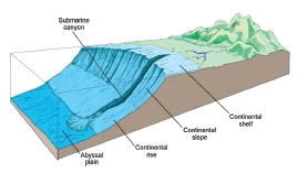
- Physical features such as submarine canyons are associated with the continental slope.
- Submarine Canyons are long, narrow and very deep valleys or trenches which are located on the continental shelves and slopes with vertical walls.
- These physical features resemble the continental canyons and are called Submarine canyons because of their location beneath the water.
- These physical features start from continental shelf break and extend up to continental slopes.
- Unlike deep-sea trenches, which are found mostly on plate boundaries, undersea canyons are found along the slopes of most continental margins.
Continental Rise
- It is a main depositional system in oceans made up of thick sequences of continental material that accumulate between the continental slope and the abyssal plain.
- The thick sediments that form continental rise accumulate as a result of three sedimentary processes: mass wasting, the deposition from contour currents, and the vertical settling of clastic and biogenic particles.
Abyssal Plains or Deep Sea Plain
- They are extensive plains that lie between the mid-oceanic ridges and the continental margins.
- These are the areas where the continental sediments that move beyond the margins get deposited.
- These areas are the smoothest and flattest surfaces on Earth which are covered with sediments such as silt and mud.
- These plains are extensively found in the Atlantic Ocean and unusual in the Pacific Ocean.
Ocean Deeps or Trenches
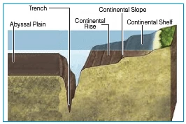
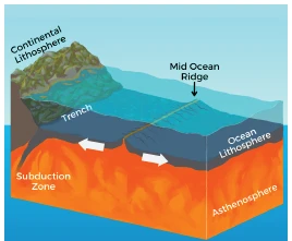
- Ocean deeps represent depressions and trenches on the ocean floors which are the deepest zones of the ocean basins. These are generally located parallel to the coasts facing mountains and along the islands, on the subduction zones of oceanic plates.
Mid Ocean Ridges
- It happens along divergent plate boundaries, where the new ocean floor is shaped as the Earth's tectonic plates spread apart. Molten rock is outpoured to the seafloor due to movement of plates separately from each other.
- The rate at which spreading occurs impacts the formation of ridges. Slower spreading rates lead to steeper and more irregular topography, whereas faster spreading rates result in wider profiles with gentler slopes.
- Two mid-ocean ridges within the global system are the Mid-Atlantic Ridge and the East Pacific Rise.
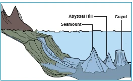
Minor Relief Features
| Abyssal Hills |
|
| Sea Mount |
|
| Guyot |
|
| Atoll |
|
Branches of Oceanography
- Physical Oceanography: It is the study of ocean waves, currents, tides, and heat transfer to understand how the oceans interact with Earth's climate and atmosphere.
- Chemical Oceanography: It studies the chemical composition of seawater which includes seawater including salinity, nutrients, dissolved oxygen, ph levels, and marine pollution.
- Biological Oceanography: It studies marine life, ecosystem, food web and organisms from microscopic phytoplankton to large marine mammals.
- Geological Oceanography: It studies the structure and history of the ocean floor such as marine sediments, underwater volcanoes, tectonic plates, and deep ocean trenches.
- Geophysical Oceanography: It studies the physical forces which shape the seafloor and uses the seismic, magnetic, and gravitational data for mapping the ocean crust.
FAQs about Oceanography
What is Oceanography?
Oceanography is the scientific study of oceans, seas of the world and covers their interacting physical, chemical and biological processes.
