
 80813-00200


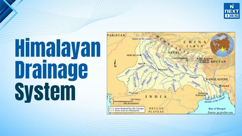
The Himalayan drainage system is a large network of perennial or evergreen rivers, including the Indus, Ganga and Brahmaputra river system. It originates from high altitude regions in the Mountains, in the northern part of India with a total of 1.65 Lakh sq. Kms. The drainage system receives water throughout the year from the melting of snow from mountain peaks and monsoon rainfed.
The most interesting part about himalayan drainage system is that the rivers like the Indus and Brahmaputra are even older than the existence of the Himalayas. On their way, the drainage system forms Gorges, V-shaped valleys in the upper Himalayas and meanders, ox-bow lakes in the plains of the northern region.
About Himalayan Drainage System
- The Himalayan River System mainly comprises the Indus, the Ganga, and the Brahmaputra river basins.
- These rivers are fed both by the melting of snow and precipitation. Therefore, rivers of this system are perennial.
- These pass through the giant gorges carved out by the erosional activities carried on simultaneously with the uplift of the Himalayas. Besides deep gorges, these rivers also form U-shaped valleys, V-shaped valleys, rapids and waterfalls in their mountainous course.
- In plains, they form depositional features like flat valleys, meanders, ox-bow lakes, flood plains, braided channels, and deltas near the river mouth.
- In the Himalayan regions, the course of these rivers is highly tortuous, but over the plains, they display a strong meandering tendency and shift their courses frequently.
- The course of the Kosi River is unstable and prone to significant erosion, which ultimately increases the sediment load in its flow. So, due to this increase in sediments, Kosi frequently changes its course. Also, Kosi which is known as the 'Sorrow of Bihar'.
Evolution of Himalayan Drainage
There are differences of opinion about the evolution of the Himalayan rivers:
- Geologists believe that a significant river, known as the Shiwalik or Indo-Brahma, once traversed the entire length of the Himalayas, extending from Assam to Punjab, and onward to Sindh, eventually discharging into the Gulf of Sindh near lower Punjab during the Miocene period, approximately 5-24 million years ago.
- The continuous stretch of the Shiwalik, combined with its lacustrine origin and alluvial deposits of sand, silt, clay, boulders, and conglomerates, supports this theory.
-
Over time, the Indo-Brahma River is thought to have been divided
into three main drainage systems:
- The Indus and its five tributaries in the Western part.
- The Ganga and its Himalayan tributaries are in the Central part.
- The Brahmaputra in Assam and its Himalayan tributaries in the Eastern part.
- This dismemberment likely occurred due to the Pleistocene upheaval in the western Himalayas, including the uplift of the Potwar Plateau (Delhi Ridge), which created a water divide between the Indus and Ganga drainage systems.
- Similarly, the downward thrusting of the Malda gap area between the Rajmahal hills and the Meghalaya plateau during the mid-Pleistocene period redirected the Ganga and Brahmaputra systems to flow towards the Bay of Bengal.
Key Features
The key features of the Himalayan River System are:
- Very young Drainage Pattern
- Seasonal Flow
- Steep Gradients and V-Shaped Valleys
- Meandering Courses and Oxbow Lakes
- Sediment-laden Rivers
Major Himalayan River System
Major Himalayan drainage systems are the Indus, the Ganga and the Brahmaputra rivers. All these major river systems have been discussed in the section that follows.
Indus River System
- It originates from a glacier near Bokhar Chu in the Tibetan region in the Kailash Mountain Range near the Mansarovar Lake.
- The river flows northwest and enters the Ladakh region of India at a place called Demchok.
- After entering India, the Indus River flows in between the Karakoram and Ladakh ranges.
- In Tibet, it is known as 'Singi Khamban or the Lion's Mouth'.
Ganga River System
- The holy river Ganga is a major river of the Indian subcontinent rising in the Himalayan mountains and flowing about 2,525 km generally eastward through a vast plain to the Bay of Bengal.
-
Flowing through a vast length, it crosses five states of India
namely:
- Uttarakhand,
- Uttar Pradesh,
- Bihar,
- Jharkhand, and
- West Bengal.
- It has a catchment area of 8,61,404 sq. km (26.4%) of India.
-
Major tributaries of River Ganga are:
- Yamuna,
- Ramganga,
- Gomti,
- Ghaghara,
- Gandak,
- Damodar, and
- Kosi etc.
- It originates from the Yamunotri Glacier near Bandarpoonch Peak in the Mussoorie range of the Lower Himalayas.
- The Yamuna River flows through the states of Uttarakhand, Himachal Pradesh, and Haryana, then enters Delhi and merges with the Ganga near Triveni Sangam in Allahabad (Prayagraj).
Note: The Yamuna River is the largest tributary of the Ganga in the northern plains.
Brahmaputra River System
- The Brahmaputra (meaning the Son of Brahma) rises in the Chemayungdung glacier in southwestern Tibet.
- Its source is very close to the sources of Indus and Satluj.
- In spite of the exceptionally high altitude, the Tsangpo has a gentle slope.
- The river flows slowly and features a wide, navigable channel for approximately 640 kilometers.
Importance in the Indian Subcontinent
Water Supply - The rivers that emanate from the Himalayas, such as Ganges, Brahmaputra and Indus, serve as an important source of water for domestic and industrial purposes and irrigation. These rivers have a constant flow of water due to their perennial nature because the source of water is both monsoon and glacial.
Agriculture - The fertile alluvial planes created by the Himalayan rivers facilitate farming and agriculture in the region. Areas like the Indo -Gangetic Plain are one of the most productive regions for agriculture in the world; rice, wheat, sugarcane and a variety of vegetables are cultivated there.
Hydroelectric Power - Steep gradients and large water flows of the Himalayan rivers allow to use them to produce hydroelectric power. Many dams and hydroelectric facilities have been built in the area due to this potential.
Biodiversity and Ecosystems - Diversity of ecosystems facilitated by the Himalayan drainage system contains a large variety of flora and fauna. River basins of the rivers create a habitat for many kinds of fish, birds and other wildlife.
Cultural and Religious Importance - There are many rivers in India that originate from the Himalayas and have deep cultural and religious meaning for people living in this country and in neighboring countries. For example, the Ganges River is very important for Hindus and millions of pilgrims visit the banks of this river.
Economic Activities - Various economic activities are conducted in the Himalayan rivers, such as fishing, tourism and transportation. The river valleys are home to many communities which make their living using these waterways.
FAQs about Himalayan River Network
Which rivers are important in the Himalayan drainage system?
Indus, Ganga, Brahmaputra, Yamuna and tributaries are important rivers in this system.
Why is the Himalayan river system perennial?
Due to the source of glaciers and snow, these rivers flow year-long.
