

Aravalli Range: Recent Controversy, Geological Formation
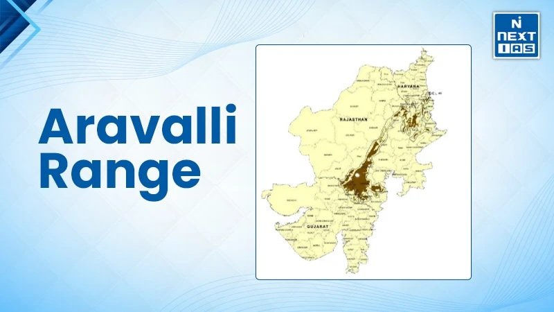
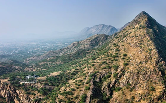
The Aravalli Range is one of the oldest Fold Mountain systems in the world, stretching approximately 692 km across several north-western states, from Gujarat to Delhi. It acts as a natural barrier from the Thar Desert and a lifeline for the fragile ecosystem of western India. However recently the region is facing various environmental concerns due to encroachment and urbanization.
About the Aravalli Range
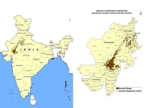
- The Aravalli Range is stretched approximately 692 kilometres from Gujarat through Rajasthan to Haryana and Delhi, forming a discontinuous chain of ridges and peaks; and its width varies between 6 to 60 miles.
- The mountain range runs southwest to northeast, starting near Palanpur in Gujarat to Delhi.
- It is divided into two sections, the Sambhar Sirohi Range and the Sambhar Khetri Range, extended approximately 560 km, in Rajasthan.
- The highest peak of the range is Guru Shikhar (1,722 metres), located near Mount Abu.
- West of it lies the Thar Desert, and to the east of the range lie the Gangetic Plains.
- The Aravalli range acts as a natural barrier preventing the Thar Desert from expanding eastwards and helps to maintain the climatic balance of the Indo-Gangetic plains.
Recent Controversy
- In 2024, the Supreme Court of India noted that various criteria were being employed to define the range of hills in the Aravalli Range by states, creating ambiguity in protection.
- Later in 2025, a Centre-appointed expert committee under the Ministry of Environment, Forest and Climate Change (MoEFCC) suggested a technical definition, where only landforms with 100 m or more and an inter-hill gap of 500 m or less should be considered Aravallis.
- This proposal was accepted by a Supreme Court bench that was headed by then CJI B. R. Gavai.
- But experts and the Forest Survey of India (FSI) cautioned that this would cover up to 90% of hills in Rajasthan (11,000 of 12,000) and affect low-lying areas such as Delhi-NCR badly.
- After popular outcry and petition, another bench headed by CJI Surya Kant in December 2025 took suo motu cognizance and granted an interim stay on the November order, with the 100-m rule remaining suspended.
- Afterward, on 15 March 2026, the MoEFCC established a 10-member High-Powered Expert Committee (HPEC) to develop a scientific definition based on satellite imagery and geological evidence through a uniform approach.
Geological Formation
- The Aravalli range is one of the world's most ancient geological formations dating back to around 2.5 to 3.5 billion years ago, during the Pre-Cambrian era.
- At present the ranges are in the form of residual mountains and plateaus, the result of weathering and erosion over millions of years by natural forces.
- The range is generally divided into two groups:
- Northern Aravalli Range (Delhi and Haryana) — marked by isolated rocky hills and ridges.
- Southern Aravalli Range (Rajasthan and Gujarat) — marked by higher peaks and plateaus.
- The mountain is composed mainly of gneiss, schist, quartzite, marble and phyllite.
- It is also dominated by valuable minerals such as zinc, lead, copper, mica and marble.
Climatic and Ecological Significance
- The Aravalli Range serves as a natural barrier between the Thar Desert in the west and the semi-arid and sub-humid regions of eastern Rajasthan, Haryana, and Delhi.
- The range also acts as an ecological barrier and "green lungs" for north-western India, which helps to control desertification, reduces air pollution and mitigates local temperatures, especially around the National Capital Region.
- The Aravalli range runs parallel to the direction of the South-West Monsoon winds; this means it does not act as a major rain-bearing barrier like the Western Ghats.
- As a result, the western side receives less rainfall (desertic conditions), whereas the eastern side supports semi-arid vegetation and fertile soil due to slightly higher precipitation.
- Rivers like Banas, Luni, Sabarmati, and Sahibi etc. Originate from the Aravallis, helping in feeding water-scarce regions of Rajasthan and Gujarat.
- As per MoEFCC, around 400 plant species, 200 bird species, and 100 animal species as well as several unique animals such as jackals and mongooses have been documented in the Aravalli ecosystem.
- The Aravalli ranges are the houses of several protected areas like Sariska Tiger Reserve, Kumbhalgarh Wildlife Sanctuary, Mount Abu Wildlife Sanctuary, and Jaisamand Sanctuary and many sacred groves.
- Predominantly dry deciduous forests and thorny scrublands in this region support a vital habitat for a diverse range of wildlife, including the Leopard, Striped Hyena, Golden Jackal, Nilgai (Blue Bull), and various species of reptiles and birds, including the Indian Peafowl.
Protected Areas in the Aravalli Range
- Sariska Tiger Reserve (Rajasthan) – Alwar district; part of Project Tiger.
- Ranthambore Tiger Reserve (extension region in Aravalli foothills) – connects with Aravalli.
- Mount Abu Wildlife Sanctuary (Rajasthan) – rich in flora and fauna, includes Guru Shikhar Peak.
- Kumbhalgarh Wildlife Sanctuary (Rajasthan) – habitat for leopards, wolves, and sloth bears.
- Jaisamand Wildlife Sanctuary (Rajasthan) – near Udaipur, supports dry deciduous forest ecosystem.
- Bassi Wildlife Sanctuary (Rajasthan) – part of Aravalli hills near Chittorgarh.
- Asola–Bhatti Wildlife Sanctuary (Delhi–Haryana) – part of the northernmost Aravalli ridge; vital urban biodiversity hotspot.
Passes in Aravalli Range
- Haldighati Pass – Connects Rajsamand and Udaipur
- Desuri Pass – Connects Marwar and Mewar
- Saddle (Sadri) Pass – Connects Sadri and Desuri
- Kumbhalgarh Pass – Connects Udaipur and Pali
- Dewar Pass – Connects Mount Abu and Sirohi plains
- Goram Ghat Pass – Connects Rajsamand and Pali
- Phalna Pass – Connects Marwar Junction and Udaipur
Economic Activities
-
Mineral resources: The Aravalli mountain range is immensely rich in metallic and non-metallic
mineral deposits:
- Metallic Minerals: Copper (Khetri region), Lead, Zinc (Zawar deposits)
- Non-Metallic Minerals: Marble (Makrana marble, used in the Taj Mahal), Granite, Quartzite, Mica, and Rock Phosphate etc.
-
Tourism: The range is also marked by historical forts and palaces:
- Sites like Mount Abu, Sariska, Kumbhalgarh and Neemrana etc. Attract large numbers of domestic and international tourists.
- The UNESCO World Heritage Sites of Kumbhalgarh Fort and Chittorgarh Fort.
- Mount Abu, a famous hill station and a major pilgrimage site, is home to the exquisite Jain Dilwara Temples.
Do you know?
- Guru Shikhar, located near Mount Abu in Rajasthan is the highest point of the Aravalli Range.
- Mount Abu is a major pilgrimage center, where Dilwara Temples of Jainism is located.
- Dilwara Temples: These are a complex of five magnificent Svetambara Jain temples built between the 11th and 13th centuries.
- Kumbhalgarh fort: It is renowned for having the second longest continuous wall in the world (after the Great Wall of China), stretching for over 36 kilometres. It was built by Rana Kumbha, in the 15th century.
Contemporary Challenges
Over the years, the Aravalli range is facing severe ecological degradation due to unregulated mining activities, deforestation and urban encroachment etc.
- Illegal mining and quarrying: causing large scale destruction of the landscape and loss of wildlife habitats.
- The Supreme Court, in 2002 and in 2009 banned mining activities in the region, but illegal activities have continued.
- According to CAG (2018), 31 of 128 hills in Aravallis (Haryana) have disappeared due to illegal mining.
- Deforestation and Biodiversity loss: large scale deforestation of the Aravallis has resulted in the loss of native flora and fauna, threatening species such as Leopards, Hyenas and Indian Gazelles etc.
- According to FSI (Forest Survey of India) reports, forest cover in parts of the Aravallis has declined by over 30%.
- Desertification risk: The degradation of Aravalli has increased the risk of eastward expansion of the Thar Desert.
- Agriculture and Water Supply: The range sustains local agriculture by aiding groundwater recharge and preventing desert encroachment.
- Recently the degradation has worsened the water crisis in Delhi, Haryana, and Rajasthan regions.
Conservation and Development Initiatives
Govt of India and state governments have taken several initiatives for restoration and protection of the Aravalli ecosystem, such as:
- LiFE (Lifestyle for Environment) initiatives: The LiFE initiative aims to integrate afforestation, water conservation and community-driven sustainability restoring ecological balance and curbing desertification.
- Inspired by Africa's Great Green Wall, the government of India has launched the Aravalli Green Wall Project (by MoEFCC, 2023).
- Under this initiative a 1,400 km long and 5 km wide tree-planting belt will be created stretching across Gujarat, Rajasthan, Haryana, and Delhi.
- The purpose of this initiative is to restore 5 lakh hectares of degraded land which will help in improving biodiversity and mitigating the effects of climate change.
- Aravalli Plantation Drive under the Green India Mission and CAMPA funds.
- Notification of Eco-sensitive Zones (ESZs) around wildlife sanctuaries.
- Supreme Court intervention: Ban on illegal mining in the protected Aravalli belts.
- The Aravalli Rejuvenation Plan which aims to promote soil conservation, water harvesting and biodiversity.
- Restoration of the Aravalli Biodiversity park in Gurugram and Delhi ridge are successful models for urban ecological conservation.
Way Forward
The Aravalli range is not just a geological structure but an ecological lifeline for the north-western part of India. Its protection will ensure groundwater security, improved air quality and sustainable environmental conditions. For this purpose, the following steps should be taken:
- Creation of a trans-boundary management authority for better coordination among the sharing states — Delhi, Haryana, Rajasthan and Gujarat.
- Promotion of nature based solutions by integrating initiatives such as LiFE with other national missions on environmental studies.
- Strict enforcement of mining bans and environmental laws.
- Community based forest management, including eco-tourism development.
- Integration of GIS-based monitoring for land use and deforestation tracking.
- Promotion of climate resilient afforestation with native species.
Conclusion
The Aravalli range plays a crucial role in shaping the climate, ecology and livelihood of north-western part of India. Though safeguarding the system of this range is not just an environmental obligation but a national priority to ensure sustainable growth, biodiversity conservation and climate security for future generations.
FAQs about Aravalli Range
Which mountain range in India is the oldest?
The Aravalli mountain Range is the oldest mountain range in India, and one of the oldest in the world.
Which is the highest peak in the Aravalli mountain range?
Guru Shikhar (1,722 meters) near Mount Abu in Rajasthan is the highest peak in the Aravalli mountain range.
How many states does the Aravalli mountain range pass through?
The Aravalli mountain range passes through the states of Gujarat, Rajasthan, Haryana, and Delhi.
What is the ecological significance of the Aravalli Mountains?
The Aravalli Mountain ranges help in preventing the expansion of the desert, play a crucial role in groundwater recharge and help to maintain climatic balance in the northwestern part of India.