
 80813-00200



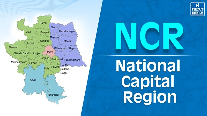
The full form of NCR is the National Capital Region (राष्ट्रीय राजधानी क्षेत्र). The region covers 3 nearby states (Uttar Pradesh, Haryana, and Rajasthan). It is one of the largest urban agglomerations in the world (by area). The Delhi NCR has about 7% contribution to the Gross Domestic Product (GDP) of India. The NCR is surrounded by the Eastern and Western Peripheral expressways to by-pass heavy inter-state traffic. The Namo Bharat RRTS rail network smoothly connects the distant regional satellite cities.
The Centre constitutes the NCR planning board, prepares the regional planning, looks after the implementation, and finances the approved projects through central and state funds. The participating states and Union Territory (Delhi) prepare the project plans at sub-regional level. The board can seek reports, review the progress, and approve the projects on priority basis.
History of NCR
The basic idea of the National Capital Region or NCR was proposed in the Master Plan for Delhi 1962 to regulate the fast growth of population and overcrowding of the city. The main purpose to form an NCR is to evolve it into a regional urban hub including the satellite towns surrounding Delhi.
To execute this planning, the parliament of India enacted the National Capital Region Planning Board Act in 1985. In many decades, the NCR expanded to a large area and included the nearby regions of Delhi (Uttar Pradesh, Haryana, and Rajasthan). It covers an approximate area of about 55,000 square kilometres.
Brief Description of Delhi NCR
| S.No. | Parameter | Details |
|---|---|---|
| 1 | Full Form | National Capital Region |
| 2 | Constituent Units |
|
| 3 | Total Area | About 55,083 sq. km |
| 4 | Important Cities |
|
| 5 | Governing Planning Body | National Capital Region Planning Board (NCRPB) |
| 6 | Primary Economic Drivers |
|
| 7 | Major Transit Assets |
|
List of Districts in Delhi NCR Region
| S.No. | State or UT | Districts in NCR | Total |
|---|---|---|---|
| 1 | Delhi (NCT) | Entire National Capital Territory of Delhi | 1 UT |
| 2 | Haryana | Faridabad, Gurugram, Nuh, Rohtak, Sonipat, Rewari, Jhajjar, Panipat, Palwal, Bhiwani, Charkhi Dadri, Mahendragarh, Jind, Karnal | 14 |
| 3 | Uttar Pradesh | Meerut, Ghaziabad, Gautam Buddha Nagar, Bulandshahr, Baghpat, Hapur, Shamli, Muzaffarnagar | 8 |
| 4 | Rajasthan | Alwar, Bharatpur | 2 |
National Capital Regional Planning Board (NCRPB)
- Authority: The board was constituted under NCRPB act of 1985 under the Ministry of Housing and Urban Affairs.
- Mandate: It formulates the regional development planning to promote balanced economic and physical development across all member states.
- Infrastructure Financing: It provides the financial support and soft loans to state governments for important urban, transport, and water supply projects.
- De-Crowding Method: It helps in reducing the unplanned migration into Delhi. It is usually done by simply expanding the satellite centres.
Transportation in this Region
The transportation in the National Capital Region of Delhi (NCR) region depends on the multi-modal metro system. It includes expressways, Delhi Metro, regional rail network (RRTS), among others. The interconnected system offers daily public travel, reduces city traffic, and improves the freight movement across neighbouring state borders.
RRTS
The Namo Bharat Regional Rapid Transit System (RRTS) is a semi high speed rail network which connects the major urban centres in the Delhi NCR. It is designed for speeds of up to 180 kilometres per hour which further reduces the daily time travel to a large extent. The RRTS began with the Delhi to Ghaziabad to Meerut corridor.
Expressways
A large network of expressways that passes through the Delhi NCR are the Eastern Peripheral Expressway, Western Peripheral Expressway, Delhi-Meerut Expressway, and Delhi-Mumbai Expressway. These expressways are helpful in by-passing the high amount of traffic around Delhi for a smooth connectivity.
Railway
Delhi NCR is an important centre for the Indian Railways and comprises New Delhi, Old Delhi, Anand Vihar, and Hazrat Nizamuddin railway stations. The dedicated freight corridors (DFC) are being utilized for tackling the passenger and freight traffic.
Metro
The Delhi Metro system is the spinal cord of the city transportation in Delhi NCR. It covers about 390 kilometres of area with hundreds of stations. It connects Delhi region with the satellite cities of Noida, Greater Noida, Ghaziabad, Gurugram, and Faridabad.
Airport
Indira Gandhi International Airport in Delhi is the main international aviation center. The airport is supported by the Noida International Airport in Jewar and Hindon Airport in Ghaziabad which handle the expansion of regional air travel and cargo demands.
Proposed ORC
The proposed Outer Ring Road (ORC) is a high speed orbital expressway surrounding Delhi. It connects the National Capital Region(NCR) of Delhi. It diverts heavy traffic that does not require entering the capital. It will reduce congestion, help the logistics sector, and improve connectivity among Noida and Ghaziabad in Uttar Pradesh, Gurugram and Sonipat in Haryana.
Counter Magnet Areas
The urban areas that lie outside the national capital region are chosen for accommodating the migration flow of people heading towards Delhi. It will develop into an automatic or self-reliant commercial and industrial centre. The important Counter Magnet Areas(CMA) are Hisar and Ambala in Haryana, Bareilly and Kanpur in Uttar Pradesh, Kota and Jaipur in Rajasthan, Patiala in Punjab, Gwalior in Madhya Pradesh, and Dehradun in Uttrakhand.
FAQs
What is the full form of NCR?
The full form of NCR is the National Capital Region.
What is Delhi NCR?
Delhi NCR is a region that includes Delhi and nearby areas such as Uttar Pradesh, Haryana, and Rajasthan.
Is Meerut in NCR?
Yes, Meerut is one of the districts that comes under Delhi NCR.
