Study on Turkey Earthquake
Syllabus: GS1/Geophysical Phenomenon
Context:
- A study published in the Journal Science unearthed the intricate union of tectonic forces that led to the Turkey earthquake.
About:
- Scientists used an array of geophysical observations to produce models of how the ruptures occurred, and found at least six faults, including a large portion of the East Anatolian Fault.
- These observations and models are important for understanding strike-slip faults and forecasting seismic hazards.
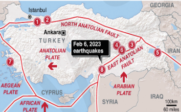
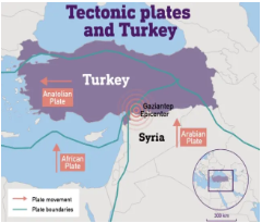
| Background: – The Kahramanmaraş earthquake sequence in Turkey in February 2023 caused a tremendous amount of damage and loss of life. 1. A magnitude 7.8 earthquake occurred in southern Turkey near the northern border of Syria, and it was followed by a magnitude 7.5 earthquake located in the southwest. – The sequence occurred across several faults, including and associated with the East Anatolian Fault, a strike-slip fault that has had many major earthquakes in the past. – The first earthquake was the most devastating to hit earthquake-prone Turkey in more than 20 years and was as strong as one in 1939, the most powerful recorded there. – It was centred near Gaziantep in south-central Turkey, home to thousands of Syrian refugees and the many humanitarian aid organisations. 1. Gaziantep is situated on the Sajur River on the Aintab plateau. Other Zones: – The Narlı Fault and Cardak–Surgu Fault Zone are located in eastern Turkey, which extend from the southern to the northeastern part of Turkey, roughly parallel to the border with Armenia. |
Major Highlights of the Study:
Geological Anatomy:
- Turkey is located on the Anatolian tectonic plate, which is wedged between the Eurasian and African plates. On the north side, the minor Arabian plate further restricts movement.
- The earthquakes in Turkey occurred along the East and North Anatolian Fault Lines that were constantly colliding with each other.
Cascade of ruptures:
- Because of continuous and unusual interaction of plates, fault bends and step-overs are like curves and gaps in a road.
- It initiated a cascade of ruptures, resulting in a larger-than-usual total rupture length and a more tremendous potential for destruction.
Methodologies:
- Kinematic slip inversion: It is like rewinding an earthquake video to understand how fault surfaces moved, indicating what might have occurred underground.
- Fault-property modelling: In this method, researchers estimate the characteristics of the fault, like friction and material properties, to predict how an earthquake is likely to spread along it.
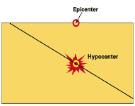
| Back to Basics: What is an earthquake? – The earth’s crust consists of different tectonic plates, and the line where they interact, collide, pull apart or slide past each other is known as ‘fault lines’. – When these plates abruptly grind and slip past each other, they release massive amounts of energy in the form of seismic waves, leading to earthquakes. It spreads through the earth and causes the shaking of the ground. – Focus (Hypocenter): The location below the earth’s surface where the earthquake starts. – Epicentre: The location directly above it on the surface of the earth. Types of Faults: – Dip-slip faults: Faults that move along the direction of the dip plane. – Strike-slip faults: Faults that move horizontally. – Oblique-slip faults: These show characteristics of both dip-slip and strike-slip faults. Effects of Earthquakes: – The specific impacts can vary depending on factors such as the magnitude of the earthquake, the depth of the focus, the geology of the area, and the design and construction of buildings and infrastructure. – The major impacts include structural damage to buildings, fires, damage to infrastructure, initiation of slope failures, liquefaction, and tsunami. Can earthquakes be predicted? – An accurate prediction of an earthquake requires some sort of a precursory signal from within the earth that indicates a big quake is on the way. – Moreover, the signal must occur only before large earthquakes so that it doesn’t indicate every small movement within the earth’s surface. – Currently, there is no equipment to find such precursors, even if they exist. |
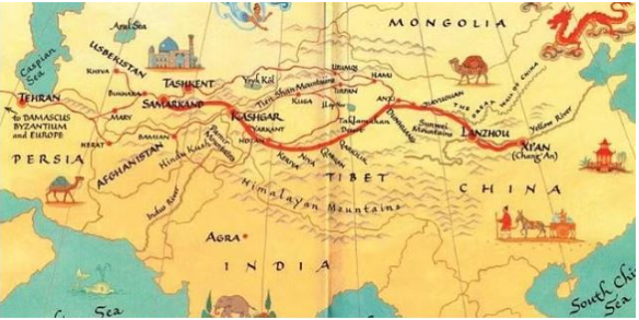
10 Year of China’s Belt and Road Initiative
Syllabus: GS2/International Relations
In News
- 2023 marks a decade since the Belt and Road Initiative (BRI), was first outlined.
About
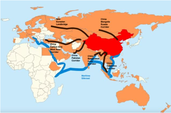
- China proposed the BRI in 2013 with the purpose of restoring the ancient Silk Route.
- The initiative aims to connect Asia with Europe and Africa, through a network of railways, highways, ports, airports, and other infrastructure projects with the intent to promote trade, investment, and economic growth in participating countries.
- China has presented the BRI as an open arrangement in which all countries are welcome to participate. So far, China has signed BRI cooperation agreements with more than 150 countries and 30 international organisations.
The BRI comprises two main components: The Silk Road Economic Belt and the 21st century Maritime Silk Road. The Silk Road Economic Belt focuses on improving connectivity and cooperation between China and countries in Central Asia, Europe, and West Asia, while the 21st century Maritime Silk Road focuses on strengthening maritime cooperation between China and countries in Southeast Asia, South Asia, and Africa.
The main portion of the required infrastructure build is expected to continue until 2035.
| Ancient Silk Road – The Silk Road was a network of trade routes connecting China and the Far East with the Middle East and Europe. – Silk was transported from east to west throughout the year except for harsh winters which brought back gold and silver coins and other precious goods in exchange. – It was established when the Han Dynasty in China officially opened trade with the West in 130 B.C., the Silk Road routes remained in use until A.D. 1453, until the Ottoman Empire boycotted trade with China and closed them. |
How does India view the BRI?
- From the beginning, India had reservations about the BRI – mainly due to sovereignty-related issues, as the China–Pakistan Economic Corridor (CPEC) goes through the Pakistan-occupied Kashmir (PoK).
- The importance of the Indian Ocean for China has increased significantly due to its expanding trade, energy transport and investments.
- It started expanding its footprints in India’s neighbourhood through investments in various ports in Bangladesh, Pakistan, Sri Lanka and Myanmar.
- As commercial ports could be easily converted into military use, these developments have troubled Indian policymakers.
- Moreover, many negative developments in broader India-China ties (trade deficit, border tensions, etc.) have also affected India’s perceptions of the BRI.
- The China’s Belt and Road Initiative structure smacks of Chinese neo-colonialism. The projects could push smaller countries on the road into a crushing debt cycle, destroy the ecology and disrupt local communities.
Conclusion
- The BRI can also be seen as China using its infrastructural, intellectual and financial advantage to forge stronger political ties with certain capital-importing countries.
- India should look up to these realities and also determine its geopolitical interests in the Indian Ocean region which could pose serious security challenges to India.
Source: IE
The UNGA Vote on Gaza War, and India’s Role
Syllabus: GS2/International Relations
Context
- The United Nations General Assembly (UNGA) voted on a nonbinding resolution calling for a ‘humanitarian truce’ in Gaza and a cessation of hostilities between Israel and Gaza’s Hamas rulers.
About:
- The resolution called for an ‘immediate, durable and sustained humanitarian truce leading to a cessation of hostilities’ and unhindered humanitarian access to the Gaza Strip, was drafted by a group of 22 Arab countries and was proposed by Jordan.
- The resolution was co-sponsored by Bangladesh, Maldives, Pakistan, Russia, and South Africa.
- However, Israel, the United States, five small Pacific island nations, and four Eastern European countries — Austria, Croatia, Czechia, and Hungary — were among the 14 members who voted against the resolution.
- India abstained in a resolution, which exemplified the balancing act it has adopted on the ongoing conflict in the Gaza Strip.
- Gaza Strip is situated along the Mediterranean Sea, and it is a Palestinian territory that shares borders with Israel and Egypt’s Sinai Peninsula.
- It, along with the West Bank, comprises the State of Palestine, with Israel acting as a dividing entity between these two regions.
Major Takeaways:
- India joined Australia, Canada, Germany, Japan, Ukraine, and the United Kingdom in the group of 45 countries that abstained on the resolution titled ‘Protection of civilians and upholding legal and humanitarian obligations’.
- The amendment proposed by Canada and co-sponsored by the US, sought to fix the responsibility of Hamas in the crisis, and asked for the insertion of a paragraph in the resolution that would state that the UNGA ‘unequivocally rejects and condemns the terrorist attacks by Hamas’.
- Unlike resolutions of the UN Security Council, resolutions of the UNGA are not legally binding. Therefore, despite the comprehensive defeat, Israel and the US are not obliged to act on the resolution.
The balanced position taken by India was in line with the one that it has maintained in the other ongoing and deeply polarising conflict in the world.
| The UN General Assembly (UNGA): – It provides a unique forum for multilateral discussion of the full spectrum of international issues covered by the Charter of the United Nations. – It is the only universally representative body of the United Nations. 1. The other major bodies are the Security Council, the Economic and Social Council, the Secretariat, and the International Court of Justice. – Each of the Member States of the United Nations has an equal vote. Role of the UNGA: – To discuss, debate, and make recommendations on subjects pertaining to international peace and security, including development, disarmament, human rights, international law, and the peaceful arbitration of disputes between nations. – It elects the nonpermanent members of the Security Council and other UN bodies, such as the Human Rights Council, and appoints the secretary-general based on the Security Council’s recommendation. – The assembly works with the Security Council to elect the judges of the International Court of Justice. Voting in the UNGA: – Article 18 of the UN Charter, and rules 82-95 of the Rules of Procedure, concern voting in the General Assembly, and an analysis of General Assembly voting can be found in the Repertory of Practice of UN Organs. – It is not legally binding. – The majority of General Assembly resolutions are adopted without a vote, and if a vote is taken, it can be documented in two ways: 1. Recorded vote: a. Must be requested before the voting is conducted; and b. Clearly identifies each Member State’s position. 2. Summary of the vote result: a. Provides the number of votes for, against, abstaining, and non-voting; b. Does not identify position of individual Member States; and c. Voting in General Assembly Main Committees. |
Way Forward:
- India’s recent involvement in the UNGA has been significant. India has taken a strong stance on terrorism, abstained from the UNGA vote calling for a truce between Israel and Hamas, and expressed deep concern over the use of violence to resolve disputes.
- India has also reiterated its support for a negotiated Two-State solution to the Israel-Palestine issue and urged all parties to de-escalate hostilities, which reflect India’s commitment to peace and security at a global level.
The Indian Railways’ Revenue Problem
Syllabus: GS3/Infrastructure: Railways
In News
- While Indian Railways (IR) has been splurging on capital expenditures (capex), there have been concerns about its operating ratio and revenue generation.
About Indian Railways
- Indian Railways is an extensive network covering over 67,000 route kilometers and serving around 8,000 stations.
- It is the world’s 4th largest railway network, followed by the US, China and Russia.
- It is often referred to as the “lifeline of India” due to its crucial role in transporting goods and passengers across the country.
- It carries over 23 million passengers and moves more than 2.5 million tons of freight daily, making it one of the busiest railway systems in the world.
- Indian Railways has been actively working on electrifying its routes to reduce its carbon footprint and dependence on fossil fuels.
Issues plaguing the Indian Railway’s Revenue
- Cross Subsidization: Indian Railways has historically kept passenger fares artificially low, leading to a situation where passenger fares do not cover the operational costs of running passenger trains. ping points –
- For instance, the Comptroller and Auditor General of India (CAG) report presented in Parliament states that there was a loss of ₹68,269 crore in all classes of passenger services during 2021-22
- High Operating Ratio: The railways have high operating costs due to a large workforce, maintenance expenses, and other operational expenditures. These costs have been challenging to reduce while maintaining service quality.
- For example, the Operating ratio during FY 22-23 is 98.14%
- Sluggish growth: In the period April-July 2023, annual growth in freight volume and revenue of the IR are 1% and 3%, respectively, while the economy grows at 7%.
- Decrease in freight transport share: Railway’s modal share in India’s freight business has steadily decreased to approximately 27% from upwards of 80% at independence.
- Limited Investment: Insufficient capital investment in infrastructure, technology, and rolling stock has hindered the railways’ ability to modernize and improve operational efficiency, which could potentially boost revenue.
- Aging Infrastructure: The railways have a vast network with a significant portion of it being outdated and in need of modernization. The cost of upgrading and maintaining this aging infrastructure strain the railways’ finances.
- Freight Tariff Structure: The complex and rigid freight tariff structure is a barrier to attracting more freight traffic.
- Underutilized Assets: Railway assets, such as land and properties, are underutilized or unused, representing missed revenue-generating opportunities.
Recommendations for improving railways revenue problems
D. K. Mittal Committee was formed in 2014 to provide recommendations on raising revenue for the Indian Railways.
- Fare Rationalization: Periodic review and adjustment of passenger fares to better reflect the operational costs.
- Implementing dynamic pricing to vary fares based on demand and time of booking, particularly for premium trains.
- Freight Tariff Reform: Simplifying the freight tariff structure to make it more competitive and transparent.
- Offering discounts and incentives for high-volume cargo and long-term freight contracts.
- Monetization of Assets: Exploring opportunities to monetize railway land and properties through commercial development, leasing, or joint ventures.
- Developing railway stations as commercial hubs with retail spaces, restaurants, and entertainment options, on the lines of National Monetization Pipeline.
- Leveraging Non-Fare opportunities:Increasing non-fare revenue by leasing advertising space on trains and in stations.
- Offering station spaces for commercial activities, such as retail, warehousing, and office rentals.
- Increasing Energy Efficiency: Focusing on energy-efficient technologies and practices to reduce operational costs.
- Exploring the use of renewable energy sources for railway operations.
- Enhancing Public-Private Partnership: Collaborating with private sector companies through PPPs to fund and operate certain railway services or infrastructure projects.
- Attracting private investments for modernization and expansion.
- Customer Outreach and Marketing: Developing marketing & promotion campaigns to promote railway services by attracting more passengers and freight customers.
Conclusion
- The future success of Indian Railways revenue growth hinges on a combination of strategic fare adjustments, infrastructure upgrades, asset monetization, and technology adoption to enhance operational efficiency and revenue generation while maintaining a focus on safety and sustainability.
Source: The Hindu
Global declaration of River Dolphins
Syllabus:GS3/Environment
News
- 11 Asian and South American countries have signed a global declaration, the “Global Declaration for River Dolphins” to preserve the river dolphin species in Bogotá, Colombia.
About
- The declaration for River Dolphins seeks to reverse the decline of all river dolphin species and bolster vulnerable populations.The efforts encompass pollution reduction, enhancing the dolphin’s habitat, freeing dolphins entangled in fishing gear.
- Participants: The declaration was adopted by the River dolphin range states like Bangladesh, Bolivia, Brazil, Cambodia, Colombia, Ecuador, India, Nepal, Pakistan, Peru and Venezuela.
- The eight pillars of the Global Declaration for River Dolphins are:
- Creating a network of protected areas;
- Enhancing management of river dolphin sites;
- Expanding research and monitoring;
- Engaging local communities and Indigenous Peoples;
- Eradicating unsustainable fishing practices;
- Improving water quality and quantity;
- Celebrating World RiverDolphin Day to raise awareness; and
- Increasing resource allocation and partnerships.
River dolphins
- River dolphins live in the world’s most important rivers, including the Amazon and Orinoco in South America, and the Irrawaddy, Ganges, Indus, Mekong, Mahakam and Yangtze in Asia.
- Significance: River dolphins are important indicators of the health of rivers.
- IUCN status: Critically Endangered (Irrawaddy dolphin and Yangtze finless porpoise) or Endangered (Amazon, Ganges, Indus and Tucuxi).
Threat
- On a global scale, river dolphin populations have diminished by 73% since the 1980s. A river dolphin species, (7th species)- the Chinese river dolphin or baiji, was declared extinct in 2007.
- Recently over 150 (and counting) dolphins were found dead in the Amazon in Lake Tefé, Brazil.
- Reasons: River fragmentation due to water infrastructure divides populations; dolphins become entangled and killed in fishing gear; and water pollution affects the animals’ health.
Source:WWF
Sand Mining
Syllabus: GS3/Environment degradation, Conservation
In News
- The Directorate of Enforcement (ED) has roped in the Indian Space Research Organisation (ISRO) and the Indian Institute of Technology- Kanpur (IIT-K) to assist investigation into allegations of excessive sand mining in Tamil Nadu.
What is Sand Mining?
- Sand mining is the extraction of sand through an open pit but sometimes mined from inland dunes from oceans, riverbeds and beaches.
- Sand is the planet’s most mined material, with some 50 billion tons extracted from lakes, riverbeds, coastlines and deltas each year, according to the United Nations Environment Programme.
- Sand is used for manufacturing, for example construction purposes and as an abrasive .
- Desert sand is useless for construction. The wind-weathered grains are too small and smooth for binding in concrete. Sea sand has similar properties from being tossed by ocean currents.
- The sand that’s ideally sized, shaped and cut out for construction comes from shorelines and the beds of rivers and lakes.
How does sand mining impact the ecosystem?
- Excessive sand mining can alter the river bed, force the river to change course, erode banks and lead to flooding.
- Disturbance of underwater and coastal sand causes turbidity in the water, which is harmful for organisms such as corals that need sunlight.
- It also destroys fisheries, causing problems for people who rely on fishing for their livelihoods.
- Mining from streams or rivers upstream can reduce water quality for downstream users and poison aquatic life.
- Sand acts like a sponge, which helps in recharging the water table; its progressive depletion in the river is accompanied by sinking water tables in the nearby areas, adversely impacting people’s daily lives.
Possible Solutions
- Guidelines on the extraction of sand say that the amount of sand removed should be in proportion to its replenishment rate and river width.
- Mining from a braided channel with a wide floodplain will have less impact than from a narrow channel.
- Manual mining is preferred over the use of machines but enforcement and monitoring of these guidelines remain weak.
- Crushing rock produces sand or “crusher dust” provides a potential alternative to river sand.
Conclusion
- Although Sand is required for the development of Human being, at the same time the threats posed due to sand mining can’t be ignored.
- Hence decisive steps are to be taken & alternate solution to be found for sand mining, without disturbing the environment.
Source: TH
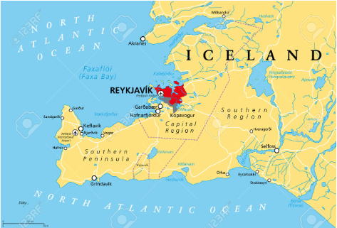
Seismic swarm In Iceland
Syllabus:GS1/Geography
News
- A seismic swarm has hit the Reykjanes peninsula in Iceland with more than 5,500 small earthquakes in the last three days.
About
- Seismic swarms are earthquake sequences without a discernible main-shock. Swarms can last weeks and produce many thousands of earthquakes within a relatively small volume.
- Swarms are observed in volcanic environments, hydrothermal systems, and other active geothermal areas.
Reykjanes peninsula
- Iceland is located between the Eurasian and the North American tectonic plates.It is a seismic and volcanic hot spot as the two plates move in opposite directions.
- The Reykjanes peninsula is in South West Iceland, characterized by immense lava fields, volcanoes, and heightened geothermal activity.
- Volcanic eruption: In the region there were no recorded volcanic eruptions for 800 years. However, for the last 2-3 years Fagradalsfjall volcano has witnessed a constant eruption.
- The main geothermal areas of Reykjanes are Gunnuhver, Krysuvik, and Svartsengi.
Source:TH
Jehovah’s Witnesses
Syllabus: GS1/Society/Culture
Context:
- Multiple blasts occurred outside the Zamra International Convention and Exhibition Centre during a religious gathering of Jehovah’s Witnesses in Kerala.
About Jehovah’s Witnesses:
- It is a Christian denomination that originated in the United States in the late 19th century. They are known for their distinctive beliefs and practices, which differ from mainstream Christianity.
Key points about Jehovah’s Witnesses
- Belief in Jehovah: Central to their faith is the belief in Jehovah as the name of God, and that the end of the world is imminent.
- They do not believe in Christian Trinity but believe in Jesus as the son of God and Jehovah as God.
- They believe Jehovah is the only true God, the creator of all things, and the ‘Universal Sovereign’.
- Jesus and the Holy Spirit: Jehovah’s Witnesses believe Jesus is distinct from God, serving as the Savior and the Son of God.
- The Holy Spirit refers to God’s active power and not a person.
- Use of the Bible: The group is known for its diligent use of the Bible, which they believe to be the ultimate authority. Their beliefs are based on all 66 books of the Bible, both from the Old Testament and the New Testament.
- They follow a literal interpretation of the Bible, have no priests, and do not approve of traditional priesthood as it is practised in some of the other Christian groups.
- Several Christian denominations do not consider the Witnesses a Christian sect at all but feel that they are aligned closer to the Jewish faith.
- Evangelism: Jehovah’s Witnesses are recognised for their door-to-door evangelism and their attempts to convert people to their beliefs.
- Unique Practices: Some of their unique practices include their non-celebration of holidays like Christmas and Easter, as they believe these have pagan origins.
- They abstain from blood transfusions, even if it means risking their lives because they consider blood to be sacred.
Group’s origin:
- The Witnesses have its early roots in a Bible study group founded in the last decades of the 18th Century by Charles Taze Russel, in Pittsburgh of Pennsylvania.
Jehovah’s Witnesses in India:
- They have been present in India since 1905, and established an office in 1926 in Bombay (now Mumbai), and obtained legal registration in 1978.
- The Witnesses benefit from the guarantees of the Constitution of India, which include the ‘right to practise, profess, and propagate one’s faith’.
Subsurface Water Ice Mapping (SWIM) Project
Syllabus: GS3/ S&T
Context
- The Subsurface Water Ice Mapping (SWIM) project funded by NASA and led by the Planetary Science Institute, has unveiled its fourth and most comprehensive map showing potential subsurface water ice locations on the Red Planet, Mars.
- The SWIM project’s initial phase, finalized in 2019, concentrated on the northern hemisphere , with the second phase in 2020 encompassing the southern hemisphere of Mars.
Significance of New Mars Ice Mapping
- Scientific Insight: Provides updated data on ice reservoirs using Context Camera (CTX) and High-Resolution Imaging Experiment (HIRISE) instruments for scientific research on Mars.
- Mission Planning: Assists in planning future Mars missions. New map highlights water ice resources for astronauts, reducing Earth water transport. Thus, it will lead to easing logistics.
- Geological Understanding: Enhances our understanding of Mars’ geology and surface features.
- Potential for Life: Helps identify potential areas for past or present life on Mars.
- Exploration Advancements: Facilitates exploration and resource utilization on the Red Planet.
About Mars
- It is the fourth planet from the Sun and is a cold desert world. It is half the size of Earth.
- It is sometimes called the Red Planet. It’s red because of rusty iron in the ground.
- It is also a dynamic planet with seasons, polar ice caps, canyons, extinct volcanoes, and evidence that it was even more active in the past.
- It has a very thin atmosphere made of carbon dioxide, nitrogen, and argon.
- There are signs of ancient floods on Mars, but now water mostly exists in icy dirt and thin clouds.
| Successful Mars Missions | Nation/ Agency |
| Mars Orbiter | USSR |
| Marine series Viking series Pathfinder Rovers: Spirit, Opportunity (2003) Phoenix (2007) Curiosity (2011) Maven (2013-14) Perseverance (2021) | NASA (USA) |
| Mars Express (2001) | European Space Agency (EU |
| Mangalyaan (MOM) (2014) | ISRO (India) |
| Amal (Hope Mission) (2021) | UAE |
| Tianwen 1 (2021) | China |
Source: TH
Ejecta Halo
Syllabus: GS3/ Science and Technology
In News
- Vikram lander which is a lander module of Chandrayan-3 generated ‘ejecta halo’ on the lunar surface.
About
- An ejecta halo is a region surrounding a landing site on celestial bodies like the moon.
- It’s created when material is ejected as an impact of a spacecraft during the landing.
- Ejecta halos are often irregular, bright patches of displaced surface material.
- ISRO has estimated that roughly 2.06 metric tonnes of lunar surface material, specifically epi regolith (layer of loose, fragmented material on moon), were expelled and distributed across an approximately 108.4 square meters region in the vicinity of the landing site.
- Ejecta halos help scientists analyze the behavior of surface materials during landing events.
Source: IE
Haemoglobin
Syllabus: GS3/Science and Technology
In News
- A study published in Nature, scientists have reported that cells that make cartilage also make haemoglobin.
About
- Scientists from China have reported that chondrocytes – cells that make cartilage, the connecting tissue between bones – also make haemoglobin and seem to depend on it for their survival.
- The discovery of functional haemoglobin in cartilage leads to the possibility that it plays a role in certain joint diseases.
What is Hemoglobin
- Hemoglobin is a type of protein in red blood cells that distributes the oxygen to muscles and tissues throughout the body.
- It also picks up carbon dioxide and returns it to lungs to exhale. This essential process helps prevent toxic levels of carbon dioxide.
- Iron is a key component of hemoglobin. Iron helps hemoglobin bind to oxygen so the hemoglobin can transport the oxygen to tissues. Iron is what makes blood red.
Hemoglobin Disorders
- Haemoglobin disorders or haemoglobinopathies are a group of conditions affecting the molecule haemoglobin which is contained in the red blood cells.
- The thalassemias are inherited blood disorders characterized by decreased haemoglobin production.
- Sickle Cell Disease: Normal red blood cells are shaped like a donut and can bend and flex easily. The cells which become sickle shaped are rigid and have difficulty passing through small blood vessels, where they can get stuck and clog the blood flow.
Source: TH
NASA-ISRO Synthetic Aperture Radar (NISAR)
Syllabus: GS3/ Science and Technology
In News
- NISAR will enhance our understanding of how changes in Earth’s forest and wetland ecosystems affect the worldwide carbon cycle and contribute to climate change.
About
- NISAR is a joint effort by NASA and ISRO, operating in Low Earth Orbit (LEO).
- NISAR features both L-band and S-band synthetic aperture radar (SAR) instruments, making it the first satellite to use two different radar frequencies.
- SAR can operate day and night, penetrating clouds, and adverse weather conditions.
- Mission Objectives: Monitoring Earth Changes: NISAR’s primary goal is to measure changes in Earth’s ecosystems, surfaces, and ice masses, offering insights into biomass, natural hazards, sea-level rise, and groundwater.
- Global Observation: The satellite will globally monitor land and ice-covered areas with a 12-day revisit frequency in both ascending and descending passes.
Source: Business Today
Exercise KAZIND-2023
Syllabus: GS3/ Defence
In News
- Indian Army and Indian Air Force contingent departed for Kazakhstan to take part in the 7th edition of Joint Military ‘Exercise KAZIND-2023’.
About Exercise KAZIND-2023
- The Joint Exercise between India and Kazakhstan was instituted as ‘Exercise PRABAL DOSTYK’ in 2016. After the second edition, the Exercise was upgraded to a company-level exercise and renamed as ‘Exercise KAZIND’.
- The Exercise has been further upgraded as a Bi-service Exercise this year by including the Air Force component.
- In this edition of the Exercise, both sides will practise conduct of Counter Terrorism operations in a sub-conventional environment under United Nations mandate.
- It will provide an opportunity for both sides to gain insight into the tactics, battle drills, and procedures of each other, which is a prerequisite while operating under the ambit of the United Nations.
Kazakhstan
- Kazakhstan is a landlocked country. It borders Russia to the north and west, China to the east, Kyrgyzstan to the southeast, Uzbekistan to the south, and Turkmenistan to the southwest, with a coastline along the Caspian Sea.
Source: AIR