The Navigation with Indian Constellation (NaVIC) is an indigenous satellite navigation system of India designed and developed by ISRO to provide accurate positioning over India and adjoining regions. It is set up to provide greater independence in regional navigation, and operations lie in navigation, disaster management, tracking of fleets, etc. Such a system lessens the dependency on world systems like GPS. This Article attempts to study Navigation with Indian Constellation (NaVIC).
About the Navigation with Indian Constellation (NaVIC)
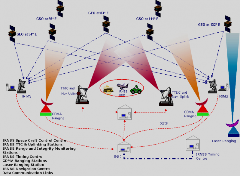
- The Indian Regional Navigation Satellite System (IRNSS) is a regional navigation system for India, independent from other systems. The idea is to set up a regional satellite navigation network with the help of some GEO and GSO satellites, apart from advanced ground systems.
- Coverage Area: The IRNSS-NavIC system intends to provide precise position information services within India and up to 1500 km outside its borders, considered the major service area. An extended service area is the region between the primary coverage area and the larger region specified by 30° South to 50° North latitude and 30° East to 130° East longitude.
- NavIC Network: It consists of a constellation of seven satellites and a complementary and sturdy ground segment with non-stop operations. Three satellites are in GSO, and four are in inclined GEO slots, while the ground segment includes a control center, facilities for precise timing, range and integrity monitoring stations, and two-way ranging stations.
- IRNSS Services: IRNSS offers two primary services:
- Standard Positioning Service (SPS) – available to all users.
- Restricted Service (RS) – an encrypted service accessible only to authorized users.
- The NavIC SPS signals are designed to be interoperable with other global navigation systems like GPS, GLONASS, Galileo, and BeiDou.
- Frequency Bands: The NavIC satellites currently use the L5 and S bands to deliver positioning data.
- Accuracy: IRNSS is expected to provide location accuracy within 20 meters in its primary service area.
Read our detailed article on Satellites.
Need of IRNSS – NavIC
Consider the following compelling arguments for the development of NavIC:
Security and Sovereignty
- It has been held that foreign systems-rather especially the American GPS-are open to security risks as they might purposely restrict or degrade access to these systems during critical times. Developing a native system like NavIC would ensure India has complete control over its navigation services, guaranteeing secured and uninterrupted access, particularly for defense purposes.
2. Regional Enhancement of Navigation Accuracy
- NavIC is designed for India and its region to provide enhanced positioning accuracy tailored to the regional requirements of South Asia. With an expected accuracy of better than 20 meters within its primary coverage area, it serves as a more accurate alternative to global systems for applications within this region.
3. For Civil Applications
- Various civil applications can be aided by NavIC in the fields of transportation, agriculture, disaster management, marine navigation, etc. By means of location-based services like fleet management, railway tracking, and personal navigation, efficiency and safety are assured in the transportation and other logistics domains.
4. Disaster Management and Emergency Response
- During natural calamities, NavIC’s reliable navigation services arrive at the scene to coordinate emergency response efforts. This calls for the correct planning, monitoring, and communication all over the disaster-affected area with location awareness and continuous coverage that is instrumental for the rescue and relief being carried out on time.
5. Regional Coverage Specific to India
- NavIC has a coverage distance focused over India and up to 1500 km beyond the country’s borders, effectively serving India’s needs without relying on global systems that have a much larger, non-specific coverage. Such a design is very low cost; optimization is, however, done for India’s geography and strategic interests.
6. Interoperability with Global Systems
- NavIC’s compatibility with other global navigation systems (GPS, GLONASS, Galileo, BeiDou) enhances its usefulness and broadens its range of applications, enabling seamless navigation and improved accuracy when combined with these systems.
Advantages of Having an Indigenous Regional Navigation System
With the establishment of the system IRNSS, India has gained entry into the limited club of nations possessing satellite navigation capabilities; it offers a myriad of paybacks:
- Self-Reliance
It acts as an independent regional navigation system for the Indian subcontinent, allowing foreign systems to be dependent on providing positional services within its coverage area. - Strengthening Regional Relations
The wide coverage of NavIC opens the possibilities of data sharing along with data access with SAARC countries, creating goodwill on the diplomatic front and in turn improving the collaboration of regional navigation systems. - Enhanced Accuracy
Upon fully operationalization of NavIC, with ground stations in Japan, France, and Russia triangulating the signals for accuracy improvement, open signals can be accurate to within 5 meters, while restricted ones have even greater accuracy over GPS signals that are usually around 20 meters in accuracy. - Constant Monitoring
Unlike GPS, NavIC utilizes satellites in geostationary orbit that maintain a fixed position with respect to Earth, thereby offering perennial coverage over the very same areas. Such an atmosphere of constant watchfulness enables the operational activities of India’s armed forces, thereby augmenting vigilance to prevent cross-border terrorism. - Effective Reception of Signals
The angle of elevation of NavIC signals over India is 90 degrees, favoring signal reception even where population density is high, in dense forests, and in mountain ranges. - Complete Control
The Indian government has absolute authority over the IRNSS-NavIC system, and therefore navigational services remain compatible with national interest.
Applications of IRNSS – NavIC
Due to its high precision and reliability for navigation, IRNSS-NavIC (Indian Regional Navigation Satellite System) finds varied applications in diverse sectors. The follows are some key NavIC applications:
- Transportation and Fleet Management
Vehicle Navigation: It provides positioning data in real time for better navigating and planning routes for vehicles.
Fleet Tracking: It assists companies in tracking and managing fleets optimally in logistics and operational cost reduction. - Aviation
Air Traffic Management: It provides navigational support to aircraft so that they can be controlled and managed for air traffic with safety and efficiency.
Precision Approaches: It helps in landing and approach procedures under difficult weather conditions, thus enhancing safety. - Maritime Navigation
Shipping and Fishing Vessels: It ensures an increased level of navigational accuracy for commercial shipping and fishing boats, thereby advancing safety and efficiency at sea.
Coastal Surveillance: The system assists in the monitoring of coastal activities for search and rescue operations and maritime security. - Agriculture
Precision Farming: Farmers can use NavIC for precise field mapping, soil analysis, and crop monitoring, leading to increased yields and efficient resource management.
Automated Machinery: Tractors and other agricultural equipment can be guided accurately, optimizing farming operations. - Disaster Management and Emergency Services
Natural Disaster Response: It assists in planning and coordinating rescue operations during natural disasters by providing accurate location data.
Emergency Services Coordination: It aids emergency services in reaching affected areas quickly and efficiently.
Way Forward
- With regard to the road ahead for NavIC, it involves increasing its capabilities and applications in various sectors for maximizing its potential benefits.
- Thus, enhancing the accuracy and reliability of the system should remain primary goals, including increasing the number of ground stations, developing next-generation satellites and so on.
- Partnering with neighboring countries and regional partners to enable data sharing and improve interoperability with other global navigation systems will bolster regional navigation services.
- Adoption of NavIC for new-age technologies such as autonomous vehicles, IoT applications, and smart cities can foster innovation and economic development.
- As with these, it will be necessary to keep developing the technology with research for new applications in areas such as agriculture, disaster management, and telecommunications.
- Fostering NavIC with these areas in mind will help establish it as a necessary tool for India’s strategic concerns and give major boosts to technological development and global presence in satellite navigation for the country.
Conclusion
- NavIC advances India’s satellite navigation capabilities to a significant degree, being an independent and tamper-proof regional system set up to meet regional needs. Its application fields are transportation, agriculture, disaster management, and defense, among others, instituting efficiency and safety in their operations.
- By providing accurate positioning data and building regional cooperation, NavIC stands as self-sufficient for India and as a goodwill tool in forging relationships with neighbors. Ultimately, NavIC sets the framework for innovations in navigational technologies, fostering India’s strategic and economic development.


