Syllabus: GS3/ Infrastructure/ Environment
Context
- The draft master plan for developing the Great Nicobar Island (GNI) has proposed to focus on tourism as the “primary economic driver” of growth.
Great Nicobar Island project
- The project received Stage-I clearance in 2022.
- Implementing authority: The project is being implemented by the Port Blair-based Andaman and Nicobar Islands Integrated Development Corporation Ltd (ANIIDCO).
- The Project involves developing an International Container Transshipment Terminal (ICTT), an international airport, township development, and a 450 MVA gas and solar-based power plant on the island.
- The site for the ICTT and power plant is Galathea Bay on the southeastern corner of Great Nicobar Island, where there is no human habitation.
The Andaman and Nicobar Islands Integrated Development Corporation (ANIIDCO)
- ANIIDCO is a quasi-government agency, incorporated in 1988 under the Companies Act.
- Its objective is to develop and commercially exploit natural resources for the balanced and environment friendly development of the territory.
- Its main activities include trading of petroleum products, Indian made foreign liquor and milk, managing tourism resorts and infrastructure development for tourism and fisheries.
Highlights of the Draft Plan
- The plan has been drafted for a projected population of 3.36 lakh by 2055.
- By that time, the master plan is expected to achieve an annual inflow of more than a million tourists.
- It proposes a township divided into several clusters: an administrative and institutional cluster, a multi-modal logistic cluster (to include airport, port, freight and passenger terminals, defence area, and green development), and tourism clusters.
- The development will start with “anchor projects” such as the International Container Transhipment Port (ICTP), the Great Nicobar International Airport, and the GNI gas and solar power plants from 2025 to 2029.
- The second part of Phase 1 (2030-2035) is expected to see growth in tourism activity and upgraded infrastructure.
- Phase 2 (2036-2041) envisages a phase of consolidation and enhanced growth of tourist traffic and the opening of opportunities for other potential economic drivers.
- The last phase (2042-2047) has been earmarked for “future development”.
Concerns over the project
- Ecological Fragility: Large-scale diversion of pristine tropical forests threatens a highly fragile island ecosystem with low carrying capacity.
- Biodiversity Loss: Destruction of habitats may endanger endemic species.
- Economic Viability Concerns: Experts questioned the economic feasibility of the project, given the high costs and ecological sensitivity of the region.
- Indigenous Rights Violation: The project allegedly violates the rights of the Shompen, a Particularly Vulnerable Tribal Group (PVTG) of hunter-gatherers. The disruption of their traditional lands and lifestyle raises human rights concerns.
- Volatile Zone: The proposed port is situated in a seismically active zone that experienced a significant geological event during the 2004 tsunami, leading to concerns about the safety and long-term stability of the infrastructure in such a location.
Significance of the Project
- Strategic Maritime Location: Its proximity to the Strait of Malacca enhances India’s ability to monitor one of the world’s busiest sea lanes.
- Strengthening National Security: Development of dual-use infrastructure (port and airport) improves India’s defence logistics, surveillance, and naval reach in the Indo-Pacific.
- Global Trade Hub Potential: The transshipment port can reduce India’s dependence on foreign ports (like Singapore/Colombo) and position India as a major logistics hub.
- Economic Development of Island Region: Infrastructure, connectivity, and urban development can boost investment, employment, and tourism in the Andaman & Nicobar region.
- Blue Economy Promotion: It supports sustainable use of ocean resources such as shipping, fisheries, and marine-based industries, aligned with India’s blue economy goals.
- Regional Connectivity and Act East Policy: Enhances connectivity with Southeast Asia, reinforcing India’s engagement under its Act East Policy and Indo-Pacific vision.
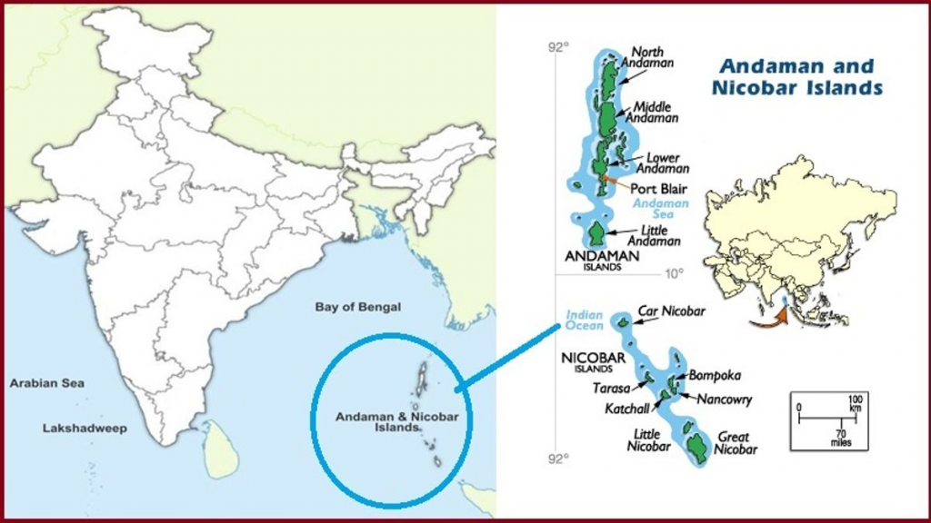
Andaman and Nicobar Islands
- Location: The islands are located 1,300 km southeast of the Indian mainland in the Bay of Bengal.
- It extends from 6° 45′ N to 13° 41′ N and from 92° 12′ E to 93° 57′ E.
- This archipelago is composed of more than 500 big and small islands, which are divided into two distinct groups of islands – The Andaman Islands and the Nicobar Islands.
- ‘Ten Degree Channel’ separates the Andaman Islands in the north from the Nicobar Islands in the south.
Facts Related to Andaman and Nicobar Islands
- The Southernmost Island is Great Nicobar whose southernmost tip is only 150 km away from Sumatra, Indonesia.
- The highest point is Saddle Peak in North Andaman (732 metre), Mount Thullier in Great Nicobar (642 metre).
- Pandunus or Nicobar Breadfruit is a rare fruit found in the Andaman and Nicobar islands.
- Barren Island of the Andaman & Nicobar Island group is the only confirmed active volcano not just in India but the whole of South Asia.
- Indira Point in Great Nicobar is the Southern-most point of India.
Source: TH
Previous article
India Withdraws Bid to Host COP 33 in 2028
Next article
News In Short 11-04-2026