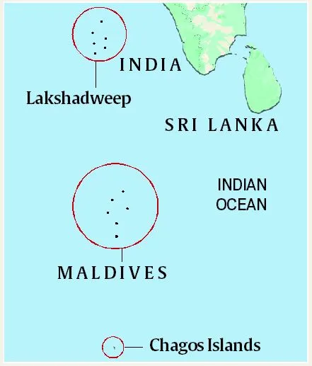
Chagos Archipelago
Syllabus : GS 1/ Places In News
Context
- India has supported Mauritius’ claims of sovereignty over Chagos Archipelago.
About Chagos Archipelago
- It is a group of islands comprising 58 islands, lying roughly 500 km to the south of the Maldives archipelago in the Indian Ocean.
- These islands were uninhabited until the late 18th century, when the French brought in laborers from Africa and India to work in newly-established coconut plantations. In 1814, France ceded the islands to the British.
- In 1965, the UK constituted the British Indian Ocean Territory (BIOT), of which the Chagos Islands were a central part.
- Chagos was attached to Mauritius, another British colony in the Indian Ocean, for administrative purposes. But when Mauritius gained independence in 1968, Chagos remained with Britain.
- Mauritius claims sovereignty over Chagos, citing historical ties before British colonial rule.
- Its largest atoll – Diego Garcia – hosts a major US military base.
Source: TH
Parvatmala Pariyojana
Syllabus: GS3/ Infrastructure
In News
- The Cabinet Committee on Economic Affairs (CCEA), chaired by Prime Minister has approved two major ropeway projects in Uttarakhand under the National Ropeways Development Programme – Parvatmala Pariyojana.
About
- Parvatmala was announced in the 2022 Budget under the Public-Private Partnership (PPP) mode.
- Implemented by National Highway Logistics Management Limited (NHLML) under the Ministry of Road Transport and Highways (MoRTH).
- Aims to develop 250+ ropeway projects covering 1,200 km in five years.
Significance of Ropeways
- Addresses connectivity challenges in remote & hilly areas.
- Boosts tourism & economy
- Provides a direct aerial route, bypassing difficult terrains.
- Minimal deforestation and land degradation.
Source: PIB
Soil Fertility Mapping
Syllabus: GS 3/Economy
In News
- Soil fertility maps have been generated for 351 villages across 34 districts in Maharashtra.
Soil Fertility Maps
- Soil fertility maps provide location-specific data, allowing farmers to apply fertilizers more efficiently, avoiding overuse or underuse.
- Soil & Land Use Survey of India (SLUSI) generates digital soil fertility maps using geo-spatial techniques and Soil Health Card (SHC) data.
- These maps guide farmers in using fertilizers and soil amendments efficiently, reducing wastage and improving economic outcomes.
| Do you know ? – Geospatial techniques, including remote sensing & AI based tools, are used in Soil Fertility Mapping. – The SHC soil sampling point is geo-coded using GPS, the sample is assigned a unique QR Code, and this QR code is retained during analysis in soil testing labs. |
Challenges
- Logistical, technical, and infrastructure barriers exist in remote and hilly areas.
- Village Level Soil Testing labs and mini-labs are addressing these challenges.
Importance
- Mapping identifies soil degradation and nutrient deficiencies, helping farmers address these issues through balanced fertilizer use.
| Other Related Schemes – Soil Health & Fertility Scheme: The scheme promotes Integrated Nutrient Management (INM), combining chemical fertilizers, organic manures, and bio-fertilizers to improve soil health and productivity. – Soil Health Card (SHC): SHCs provide information on soil nutrient status (low, medium, high) and recommendations for nutrient application to improve soil health. 1. Parameters tested include pH, electrical conductivity, organic carbon, nitrogen, phosphorus, potassium, sulphur, and micronutrients. 2. SHC data is made available to farmers, who can download their SHC by entering their registered mobile number. 3. The Soil Health & Fertility Scheme is available to all States & UTs in India. |
Source :PIB
Evolution of Computer Mouse
Syllabus :GS 3/Science and Technology
In News
- The computer mouse is essential for personal computing, allowing users to interact with virtual objects through graphical interfaces.
About
- The computer mouse, invented by Douglas Engelbart in 1963, was initially a bulky device with two wheels and a cord, resembling a mouse.
- In 1968, the first ball-based mouse was introduced by Telefuken, inspired by a military trackball device.
- The Xerox Alto in 1973 became the first computer with a mouse-driven graphical interface, and Microsoft developed the first PC-compatible mouse in 1982.
- The optical mouse, developed by Jean-Daniel Nicoud, replaced mechanical components with LEDs, and later evolved into wireless and laser mice.
Source :TH
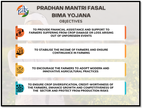
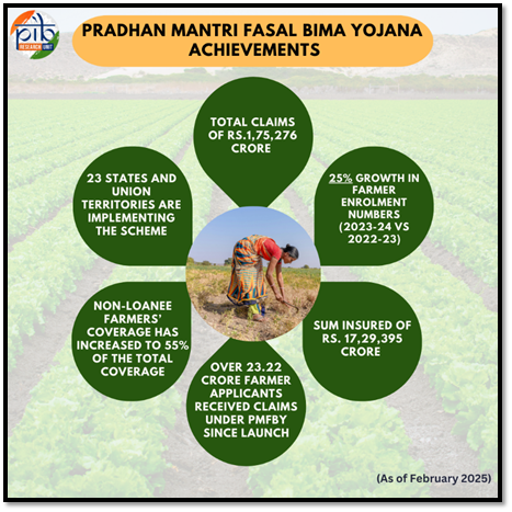
Implementation of Pradhan Mantri Fasal Bima Yojana
Syllabus :GS3/Economy
In News
- The Government has approved the continuation of Pradhan Mantri Fasal Bima Yojana (PMFBY) and Restructured Weather Based Crop Insurance Scheme (RWBCIS) till 2025-26.
Pradhan Mantri Fasal Bima Yojana(PMFBY)
- It was introduced in the Kharif 2016 season and is available for all States/UTs. It is voluntary for both States and farmers.
- Affordable Premiums: The maximum premium payable by the farmer will be 2% for the Kharif food and oilseed crops.
- For rabi food and oilseeds crop, it is 1.5% and for yearly commercial or horticultural crops it will be 5%. The remaining premium is subsidized by the government.
- Comprehensive Coverage: The scheme covers natural disasters (droughts, floods), pests, and diseases, along with post-harvest losses due to local risks like hailstorms and landslides.
- Timely Compensation: PMFBY aims to process claims within two months of the harvest to ensure that farmers get the compensation quickly, preventing them from falling into debt traps.
- Technology-Driven Implementation: PMFBY integrates advanced technologies like satellite imaging, drones, and mobile apps for precise estimation of crop loss, ensuring accurate claim settlements.
- Post-harvest Losses: The Government provides for post-harvest losses on an individual farm basis. The Government offers coverage of up to 14 days (maximum) from harvesting for crops that are stored in “cut and spread” condition.
| Do you know ? – Restructured Weather Based Crop Insurance Scheme (RWBCIS) is a weather index-based scheme, which was introduced along with PMFBY. – The basic difference between the PMFBY and RWBCIS is in its methodology for calculation of admissible claims to the farmers. |
Source :PIB
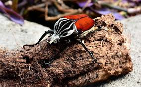
Africa’s Giant Goliath Beetle
Syllabus: GS3/ Environment; Species In News
Context
- Recent research has highlighted that two species of Goliath beetles, Goliathus regius and Goliathus cacicus, are facing the threat of extinction.
About
- The Goliath beetles (genus Goliathus) are among the largest insects in the world, with five known species.
- They can grow up to 110 mm long. Males possess Y-shaped horns, whereas females lack horns.
- They are native to the rainforests of West and Central Africa.
- Larvae (grubs) are omnivorous and consume both plant debris and animal matter, aiding in nutrient recycling in forests.
Source: TH
Previous article
World Air Quality Report 2024
Next article
Online Skill-Based Gaming