
2-System Interaction Behind Heavy Rains in the Himalayas
Syllabus: GS1/Geography
Context
- The India Meteorological Department (IMD) has warned of heavy to extremely heavy rainfall across North India due to an unusual weather phenomenon termed “2-System Interaction.”
What is 2-System Interaction?
- Definition: 2-System Interaction refers to the simultaneous occurrence and convergence of two distinct weather systems, which amplify each other and produce severe weather outcomes.
- In Current Case:
- Southwest Monsoon Trough: A low-pressure belt that channels moisture-laden winds from the Arabian Sea and Bay of Bengal.
- Western Disturbance: A cyclonic circulation originating in the Mediterranean region, carrying extra-tropical moisture and energy, usually active in winters but occasionally overlapping with monsoon.
- Result: When both interact, the combined energy and moisture lead to intense rainfall activity, often beyond normal seasonal patterns.
Why is it Significant?
- Geographical Vulnerability: The Himalayan terrain is steep, fragile, and densely populated in valleys, making it highly prone to landslides and flash floods.
- Climatic Shift: Such interactions, once occasional, are being reported more frequently due to changing monsoon dynamics and rising global temperatures.
- Hydrological Impact: Sudden surges in rainfall increase risks for rivers and reservoirs, threatening infrastructure and communities downstream.
Source: TOI
Gujarat’s Kutch Village Yields Rare Jarosite Discovery
Syllabus: GS1/ Geography, GS3/ Science and Technology
Context
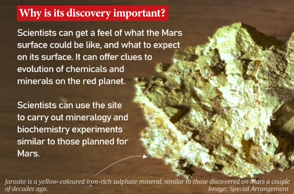
- Researchers confirm the presence of jarosite, in Matanomadh village of Kutch, Gujarat, similar to what was discovered on Mars a couple of decades ago.
- It is believed that this site could serve as a potential field analogue for the Indian Space Research Organisation’s (ISRO) upcoming Mangalyaan-2 mission.
About Jarosite
- On Earth: Jarosite is a yellow mineral, formed when oxygen, iron, sulphur, and potassium-rich minerals react with water, often under volcanic conditions.
- On Mars: First detected by NASA’s Opportunity rover in 2004 at Meridiani Planum, jarosite provided one of the strongest pieces of evidence for the presence of water in the planet’s past.
- In Matanomadh: The mineral, dated to about 55 million years ago (Paleocene period), closely resembling Martian geology.
- In India earlier it was found in Kerala’s Varkala cliffs.
- Globally deposits have been found in Mexico, Canada, Japan, Spain, and in Utah and California in the US.
Source: IE
DIGIPIN Initiative
Syllabus :GS 2/Polity and Governance
In News
- The Department of Posts has signed a Memorandum of Understanding (MoU) with ESRI India to Strengthen the DIGIPIN Initiative.
The DIGIPIN (Digital Postal Index Number)
- It is an open-source, interoperable, geo-coded, grid-based digital address system developed by the Department of Posts in collaboration with IIT Hyderabad and NRSC, ISRO.
- It divides India into approximately 4m x 4m grids and assigns each grid a unique 10-character alphanumeric code based on latitude and longitude coordinates.
- It is a cornerstone of the Department of Posts’ vision to offer Address-as-a-Service (AaaS) — an array of services associated with address data management to support secure and efficient interactions between users, government entities, and private sector organisations.
Importance
- It simplifies addressing for public and private services, improving logistics efficiency and emergency response capabilities.
Source :PIB
Buildings To be Geo-tagged in Census 2027
Syllabus :GS2/Governance
In News
- The 2027 Census will mark India’s first fully digital enumeration, featuring the geo-tagging of over 33 crore buildings—residential and non-residential—using Digital Layout Mapping (DLM) and GIS coordinates during the Houselisting Operations.
Geo-tagging of buildings in Census 2027
- This initiative replaces earlier hand-drawn sketches and aims to improve workload management and data accuracy.
- Enumerators will classify buildings by usage and collect data on housing conditions, amenities, and assets.
- The data collected will include the number of Census Houses, households, and building classifications (residential, non-residential, partly residential, landmarks).
- The Census Monitoring & Management System (CMMS) will enable real-time oversight, while geo-referenced Houselisting Block boundaries will be created using satellite imagery and administrative maps.
| Geo-tagging – It is the process of assigning a unique latitude-longitude coordinate to a specific building on a Geographical Information System (GIS) map. – Houselisting block – It means “a well-defined area in a village or in a ward of the town which can be clearly demarcated on the ground and for which a notional map is drawn for the purpose of the Census Operations. 1. Such blocks created for the Houselisting Operations (HLO)and Population Enumeration (PE) are called the Houselisting Blocks (HLBs) and Enumeration Blocks (EBs) respectively. |
Source :IE
Bond Yields
Syllabus :GS3/Economy
In News
- India’s 10-year government bond yield has increased by 26 basis points (bps) in the past month, even though the Reserve Bank of India (RBI) has cut the repo rate by 100 bps over seven months, bringing it down to 5.50%.
Key Concepts
- Repo Rate: The rate at which RBI lends short-term funds to commercial banks.
- Cutting repo rate → signals monetary easing, usually lowers borrowing costs and bond yields.
- Government Bond Yield: Yield = effective return an investor earns from a government security (G-Sec).
- Inverse relation: Bond prices ↑ → Yields ↓; Bond prices ↓ → Yields ↑.
- 10-year G-Sec yield = benchmark for overall borrowing costs in the economy.
Why are Yields Rising Despite Rate Cuts?
- High Fiscal Deficit and Borrowing Needs: Government’s large borrowing program raises supply of bonds → pushes prices down → yields rise.
- Inflationary Concerns: Even with repo cuts, sticky inflation expectations can drive investors to demand higher yields.
- Global Factors: Rising US Treasury yields, stronger dollar, and capital outflows from emerging markets impact Indian bond yields.
- Liquidity Conditions: Despite RBI’s easing, if banking system liquidity is tight, demand for G-Secs falls.
Source: TH
CEREBO
Syllabus: GS3/ Science and Technology
Context
- The Indian Council of Medical Research (ICMR) has introduced CEREBO, for the rapid diagnosis of traumatic brain injuries (TBI).
What is CEREBO?
- It is a handheld, non-invasive, and radiation-free device aimed to address diagnostic delays in rural and resource-poor settings where CT (computerised tomography) and MRI (magnetic resonance imaging) scans are inaccessible or unaffordable.
- It uses near-infrared spectroscopy (NIRS) technology powered by machine learning.
- It can detect intracranial bleeding and edema within one minute and can be operated by paramedical staff or unskilled personnel after 30 minutes of training.
Why is it needed?
- High TBI burden: India records over 100,000 TBI-related deaths annually. Half of these occur within the first two hours of injury.
- Challenges with current methods:
- Glasgow Coma Scale: Subjective and prone to errors.
- CT/MRI scans: Require advanced infrastructure, trained professionals, and are cost-intensive.
Source: TH
PRATUSH Mission
Syllabus: GS3/ Space
In News
- India has developed a credit-card sized computer for space missions, designed to catch the extremely faint signals from the universe’s earliest moments.
What is PRATUSH?
- Precise Radio Astronomy for Transient Universe Studies from High-lunar orbit (reported in concept stage).
- It envisions placing a payload in lunar orbit around the far side of the Moon.
- The mission harness the radio-quiet environment on the far side to conduct low-frequency radio astronomy free from Earth’s radio interference and ionospheric distortion.
Why the Far Side of the Moon?
- Radio Quiet Zone: The Moon shields its far side from Earth’s radio frequency interference.
- No Ionosphere Disturbance: Earth’s ionosphere blocks or distorts radio waves below ~30 MHz, limiting ground-based observations.
- Unique Observational Advantage: Allows study of cosmic dawn (formation of first stars and galaxies), interstellar plasma, and detection of ultra-low-frequency radio bursts.
Source: DST
Rosewood Tree Population in India
Syllabus :GS3/Environment
In News
- According to recent habitat modelling by the Institute of Wood Science and Technology (IWST), Bengaluru, only 17.2% of India’s suitable habitat for Indian rosewood lies within protected areas.
Indian Rosewood (Dalbergia latifolia)
- It is also known as the ivory of the forests and is valued for its rich grain, deep color, and durability.
- It is a premium timber used in furniture and handicrafts and plays a key ecological role by improving soil fertility through nitrogen fixation, supporting bird and insect diversity, and acting as a long-term carbon sink.
- It is native to India, Nepal, Bangladesh, Myanmar, Java, and Indonesia.
- In India, it is found from eastern Uttar Pradesh to Sikkim in the sub-Himalayan region, as well as in central, western, and southern parts of the country.
- It grows in various soil types but thrives best in well-drained, deep, moist soils.
- It is listed under Appendix II of CITES and has been classified as Vulnerable by the IUCN since 2018
Source :TH
Exercise Yudh Kaushal 3.0
Syllabus: GS3/Defence
Context
- The Indian Army conducted Exercise Yudh Kaushal 3.0 in the high-altitude Kameng region, Arunachal Pradesh.
About the exercise
- The exercise featured large-scale manoeuvres with drone surveillance, precision strikes, real-time target acquisition, air–littoral operations and synchronized battlefield tactics.
- A major highlight was the operational debut of the newly raised ASHNI platoons, designed to integrate advanced technology with traditional combat skills for decisive battlefield advantage.
Source: TH
Previous article
Air Quality Life Index (AQLI) 2025
Next article
India Sets Eyes on $1-Trillion Semiconductor Market