Kurukshetra January, 2025
The following topics are covered in the Kurukshetra January, 2025:
Chapter 1- ISRO's Role in Rural Development
India’s rural areas are home to over 65% of its population and constitute the backbone of the nation’s socioeconomic fabric.
- However, challenges such as fragmented agricultural practices, inadequate infrastructure, limited access to healthcare, and vulnerability to natural disasters continue to hinder the development of rural communities.
- The Indian Space Research Organisation (ISRO), through its advanced space technology, has emerged as a key enabler of rural transformation.
- By leveraging remote sensing, Geographic Information Systems (GIS), and satellite-based applications, ISRO has significantly contributed to bridging the rural-urban divide and fostering sustainable development.
ISRO and Agricultural Development
Enhancing Agricultural Productivity
- Crop Monitoring and Yield Estimation: Satellite imagery provides accurate data on crop acreage, health, and productivity. This information supports effective planning of the Public Distribution System (PDS) and export strategies.
- Pest and Disease Management: Remote sensing identifies pest-affected areas, enabling timely intervention and minimization of crop losses.
- Soil Health Management: Programs like the Soil Health Card Scheme use satellite data to analyze soil fertility, moisture levels, and nutrient deficiencies, offering farmers guidance on optimal crop selection and resource utilization.
Supporting Government Initiatives
- Pradhan Mantri Fasal Bima Yojana (PMFBY): ISRO’s satellite data facilitates accurate assessment of crop damage and quick disbursement of insurance claims.
- Digital Agriculture Mission: Through initiatives like AgriStack and Krishi Decision Support Systems (Krishi DSS), ISRO integrates remote sensing data with real-time analytics for decision-making support.
Water Resource Management
Watershed Development
- Integrated Watershed Management Programme (IWMP): ISRO’s geospatial tools enable mapping of watershed areas, aiding in soil and water conservation.
- Groundwater Recharge and Monitoring: Satellite imagery identifies groundwater depletion zones and facilitates planning of recharge structures.
Irrigation Efficiency
- Optimizing Water Use: Satellite data supports monitoring of irrigated areas, ensuring efficient allocation of water resources.
- Drought Preparedness: Tools like the National Agricultural Drought Assessment and Monitoring System (NADAMS) integrate satellite and meteorological data to forecast droughts and plan mitigation measures.
Disaster Management and Preparedness
Early Warning Systems
- Flood Management: ISRO’s Flood Early Warning System (FEWS) provides real-time alerts for floodprone areas, reducing loss of life and property.
- Cyclone Monitoring: Satellites like INSAT deliver timely weather updates and disaster alerts, enhancing preparedness.
Post-Disaster Recovery
- Damage Assessment: High-resolution imagery aids in mapping inundated areas, evaluating damages, and planning relief efforts.
Rural Connectivity and Infrastructure
Village Resource Centres (VRCs)
To enhance rural connectivity and digital inclusion, ISRO has established 473 Village Resource Centres in collaboration with NGOs and state governments. These centers provide services such as:
- Telemedicine and tele-education
- Agricultural advisories and skill development
- Career counseling for rural youth
Government Schemes
- Mahatma Gandhi National Rural Employment Guarantee Act (MGNREGA): GIS-based tools improve transparency in planning and implementation of rural employment projects.
- Pradhan Mantri Gram Sadak Yojana (PMGSY): Satellite-based mapping optimizes rural road planning, enhancing connectivity and accessibility.
Healthcare and Education
Bridging the Healthcare Divide
- Telemedicine: ISRO’s satellite-based telemedicine program connects remote healthcare facilities with specialists in urban centers, enabling consultations and training for medical staff.
- eSanjeevani: This telemedicine initiative leverages ISRO’s technology to offer healthcare services to rural populations.
Enhancing Educational Access
- EDUSAT: As the world’s first dedicated education satellite, EDUSAT facilitates distance learning for rural students, offering access to quality educational resources and reducing the urban-rural educational gap.
Land and Property Management
Land Records Modernization
- Digital India Land Records Modernization Program (DILRMP): Satellite data ensures accurate mapping of land parcels, streamlining ownership records and minimizing disputes.
- SVAMITVA Scheme: Launched in 2020, this initiative uses drones and geospatial technology to map rural land parcels, empowering villagers with property ownership records.
Bhuvan Panchayat
ISRO’s Bhuvan Panchayat portal provides geospatial data for decentralized planning, aiding Gram Panchayats in resource management and governance. It supports:
- Mapping of natural resources
- Infrastructure planning
- Monitoring of rural development projects
Promoting Aquaculture and Horticulture
Sustainable Aquaculture
- Water Quality Monitoring: Satellite data monitors parameters like chlorophyll concentration and turbidity, crucial for sustainable fish farming.
- Site Selection: Geospatial analysis identifies optimal locations for aquaculture based on salinity, nutrient availability, and pollution levels.
Horticultural Development
- Crop Stress Monitoring: Hyperspectral imaging assesses plant health, enabling better planning of production and distribution of fruits and vegetables.
- Supply Chain Optimization: Satellite data facilitates efficient management of horticultural supply chains.
BharatNet: Digital Empowerment of Rural India
BharatNet, one of the world’s largest rural broadband projects, utilizes ISRO’s satellite technology to:
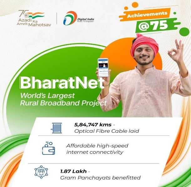
- Connect over 2.5 lakh Gram Panchayats with high-speed internet
- Enable e-governance, e-health, and e-education services
- Facilitate last-mile connectivity to households and institutions
Conclusion
ISRO’s innovative use of space technology underscores its pivotal role in transforming rural India. From agriculture and water management to disaster preparedness and digital empowerment, ISRO has made remarkable contributions to sustainable rural development. As India strides towards becoming a developed nation, leveraging space technology will be crucial in ensuring inclusive growth and reducing rural-urban disparities. ISRO’s efforts exemplify the potential of science and technology to create a better future for India’s rural population.
Chapter 2- Space Technologies: Bridging the Rural-Urban Gap in India
Space technology has revolutionized sectors like agriculture, disaster management, communication, and environmental monitoring, contributing significantly to rural development in India. Satellite-based services, remote sensing, and communication technologies have empowered rural populations and supported national growth.
Role of Space Technologies in Communication
Space technologies, particularly communication satellites like GSAT, have played a critical role in bridging the digital divide in rural India. These satellites facilitate telemedicine, e-learning, and digital governance, ensuring equitable access to services. Rural areas are now connected to global networks, improving healthcare, agricultural advisory, and government schemes.
Applications in Agriculture
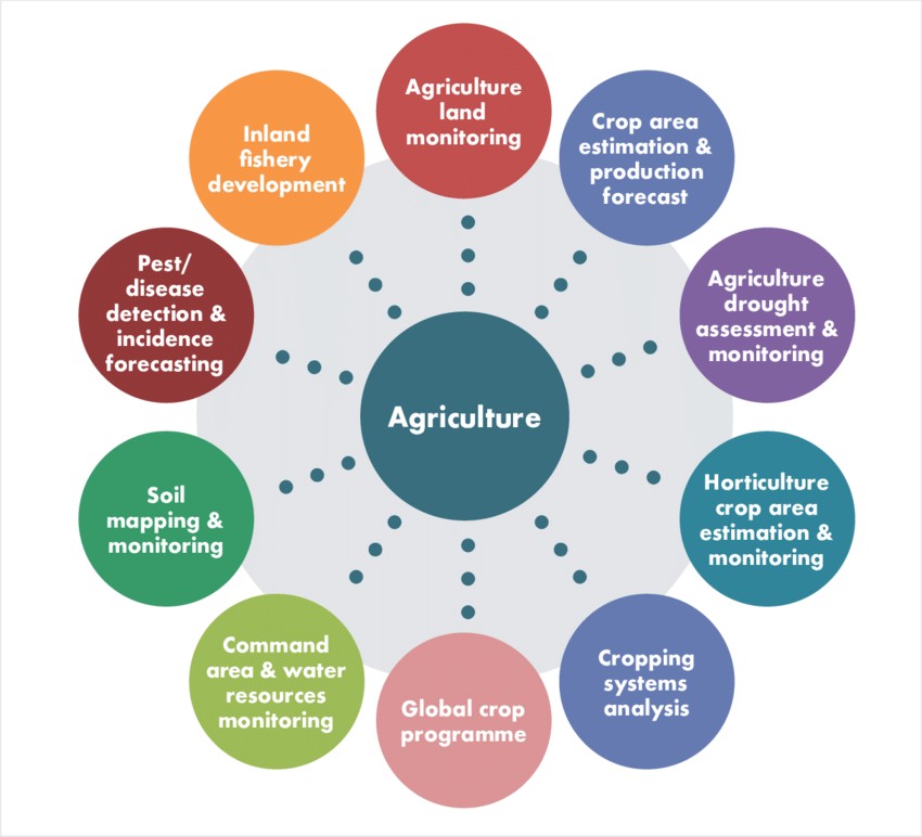
Space technology has transformed agriculture by providing critical data for crop monitoring, soil analysis, and weather prediction. Key applications include:
- Crop Monitoring and Yield Estimation: Satellite imagery helps detect issues like nutrient deficiencies and pest infestations, enabling early intervention and accurate yield estimation.
- Irrigation Management: Satellites track groundwater levels and surface water availability, helping design efficient irrigation systems.
- Agricultural Advisory Services: Platforms like Kisan Call Centers and mobile apps provide real-time advisories on best practices, pest control, and market prices, empowering farmers with actionable knowledge.
Village Resource Centres (VRCs)
In collaboration with NGOs and government agencies, ISRO has launched Village Resource Centres (VRCs) to deliver space-based services directly to rural areas. VRCs have conducted numerous programs in agriculture, healthcare, and skill development, benefiting millions in rural communities.
Disaster Management and Space Technologies
Space technologies are invaluable in disaster management. Satellites equipped with remote sensing capabilities help track hazards, assess disaster impacts, and support early warning systems. For example, satellites monitor cyclones, floods, and wildfires, aiding timely evacuations and relief efforts. GPS technology also plays a key role in locating survivors and maintaining connectivity in affected regions.
Environmental Monitoring
Satellite imagery and remote sensing tools are crucial for monitoring soil quality, water availability, and vegetation health, assisting in sustainable resource management and environmental protection. Key applications include:
- Precision Agriculture: Satellite data helps optimize irrigation and pest management.
- Tracking Deforestation and Land Degradation: Remote sensing enables monitoring of deforestation and land degradation, allowing timely interventions to protect ecosystems.
Telemedicine: Space Technology for Rural Healthcare
Launched by ISRO in 2001, the Telemedicine Program connects rural healthcare centers to urban hospitals via satellite communication. This program provides access to specialist consultations and diagnostic services, significantly improving healthcare delivery in remote areas.
Satellite-based Weather Prediction for Rural Upliftment
Satellite-based weather prediction technologies, such as INSAT-3D and Megha-Tropiques, play a transformative role in rural India, particularly in agriculture. Accurate weather forecasts help farmers make informed decisions on crop sowing, irrigation, and harvesting, thus enhancing productivity and sustainability.
Geospatial Solutions for Natural Disaster Management
Geospatial technologies, including GIS, remote sensing, and satellite imagery, are essential in managing natural disasters like floods, droughts, and forest fires. These technologies support real-time monitoring, early warning systems, and disaster response strategies.
Conclusion
Space technologies are essential in bridging the rural-urban gap in India. They contribute to improving agricultural productivity, disaster management, healthcare, and environmental sustainability. By leveraging these advancements, India is fostering a more inclusive, resilient, and sustainable future for its rural communities, ensuring a brighter tomorrow for rural India.
Chapter 3- Reimagining the Future of Learning: Educating on Space Technology
As India aspires to become a global leader in the space economy, there is an urgent need to prioritize education on space technologies. This approach can empower students and the workforce to harness its potential, driving innovation and sustainable development.
The Growing Importance of Space Technology
Space technology is pivotal in addressing global challenges like climate change, disaster management, and sustainable development. The United Nations Office for Outer Space Affairs (UNOOSA) introduced the Space4SDGs initiative, highlighting its role in achieving all 17 Sustainable Development Goals (SDGs), including Quality Education and Decent Work and Economic Growth.
Key Applications:
- Education: High-speed internet connectivity, remote learning solutions, and digital attendance systems.
- Economy: Enhancing sectors like banking, agriculture, disaster resilience, and communications to drive GDP growth.
- Global Impact: According to the World Economic Forum, the global space economy is projected to grow from $630 billion (2023) to $1.8 trillion by 2035, with an average annual growth rate (AAGR) of 9%. India’s space economy is expected to grow even faster, reaching $77 billion by 2030 at a compound annual growth rate (CAGR) of 26%.
Integrating Space Education into Learning Systems
School Curriculum:
Incorporating space technology into school syllabi can inspire students to solve real-world problems. Examples include:
- Using satellite data for renewable energy mapping.
- Teaching urban planning with geospatial technologies.
Digital Learning Post-COVID:
- Deployment of cost-effective satellite communication systems like VSAT in underserved areas.
- Promoting geospatial technologies to improve educational equity and resource management.
Global Best Practices
Countries like the USA, Japan, and the UAE provide valuable models:
- USA: NASA employs tools like augmented reality (AR) to make space concepts accessible and engaging.
- Japan: JAXA’s outreach programs include astronaut simulations and satellite design workshops.
- Europe: The European Space Agency (ESA) offers resources and competitions for space-themed projects.
Opportunities in India
India’s Space Policy 2023 outlines strategies to promote space-related education and innovation:
- Young Scientist Program (YUVIKA) by ISRO introduces students to satellite building and mission planning.
- The UN-affiliated Centre for Space Science and Technology Education in Asia and the Pacific (hosted in India) offers courses in remote sensing, satellite communications, and space science.
- EDUSAT: Bridging the rural-urban gap through satellite-based e-learning content.
Strengthening Education:
- Access to Information: Outreach programs on Indian missions like Chandrayaan and Gaganyaan, using digital media and documentaries.
- Skill-Oriented Curriculum: Introducing courses in satellite design, AI, robotics, and data analysis.
- Collaborations: Enhanced ISRO-private sector partnerships through programs like SpaceKidz and INSPACe.
- Teacher Training: Specialized training for educators to integrate space examples into teaching.
- Rural Focus: Mobile exhibitions and satellite-based resources to inspire students in underserved areas.
Challenges
- Awareness Gap: Limited understanding of space technology’s relevance beyond niche careers.
- Educator Preparedness: Lack of technical expertise among teachers.
- Curricular Resistance: Exam-oriented education discourages interdisciplinary learning.
- Socioeconomic Barriers: Rural and economically disadvantaged students face limited access to resources.
Conclusion
Space technology has transformative potential in science, economy, and sustainability. India must leverage education to prepare students for space-related careers and innovations. Key steps include:
- Integrating space technology into curricula.
- Enhancing public-private collaborations.
- Investing in rural outreach and teacher training.
Global practices offer valuable insights, but India must tailor these strategies to its unique challenges. By building a strong foundation in space education, India can not only inspire its youth but also position itself as a leader in the global space economy.
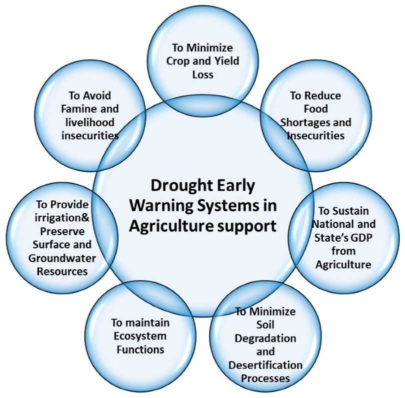
Chapter 4- Satellite-Based Early Warning Systems for Drought and Flood Management
Natural disasters like droughts and floods pose significant challenges to rural agriculture, threatening food security and farmer livelihoods.
- Satellite technology provides transformative solutions for precise monitoring, early warning, and risk mitigation.
- Combining Indian and global satellite programs with collaborative efforts can enhance disaster preparedness and promote sustainable agricultural practices.
Impact of Droughts and Floods
Droughts
A drought is a temporary reduction in water availability below normal levels due to sub-normal rainfall, erratic distribution, or high water demands. It adversely impacts humans, vegetation, livestock, and ecosystems. India faces various drought types:
- Meteorological: Caused by rainfall deficits.
- Agricultural: Insufficient soil moisture for crops.
- Hydrological: Depletion of surface and groundwater resources.
- Socioeconomic: Impacting livelihoods and economic activities.
Key Effects in India:
- Crop Yields: Insufficient water during critical growth phases reduces productivity, causing economic losses.
- Livelihoods: Persistent droughts push farmers into debt, forcing rural migration.
- Livestock: Scarce fodder and water weaken livestock health, lowering productivity.
- Water Resources: Over-reliance on groundwater depletes aquifers, creating long-term scarcity.
Floods
Floods, caused by excessive rainfall or overflowing rivers, have immediate and long-term impacts:
- Crop Destruction: Submerged fields cause complete agricultural losses.
- Soil Degradation: Topsoil erosion reduces fertility, affecting future cultivation.
- Infrastructure Damage: Essential systems like irrigation and roads are destroyed.
- Health Hazards: Stagnant water creates breeding grounds for diseases.
Satellite Imagery in Early Warning Systems
Satellites equipped with advanced sensors provide invaluable insights for disaster management:
- Rainfall Patterns: Precise data helps in forecasting weather, flood risks, and agricultural planning.
- Soil Moisture Levels: Estimating water content aids efficient irrigation and drought adaptation.
- River Monitoring: Altimetry tracks water levels, aiding flood risk assessment.
- Vegetation Health: Indices like NDVI detect crop stress and drought-affected areas.
Key Satellites and Programs
- Indian Satellites: INSAT, RISAT, and Cartosat provide critical data for monitoring weather, soil conditions, and disaster-prone areas.
- Global Initiatives: Sentinel (ESA) and Landsat (NASA) complement Indian efforts with enhanced imagery.
- Collaborations: Partnerships with FAO and WMO integrate global satellite data for improved disaster response.
Drought Management through Satellite Technology
Monitoring and Assessment
- Rainfall Anomalies: Tracking deviations in precipitation helps predict drought risks.
- Soil Moisture Mapping: Tools like SMAP provide real-time data for better water management.
- Vegetation Indices: NDVI and EVI measure crop health and guide adaptive practices.
Early Warning Systems
- Seasonal Forecasting: Long-term climatic trends aid preparedness.
- Dynamic Monitoring: Regular updates allow timely interventions.
- Community Alerts: Mobile apps and local media share warnings to empower communities.
Mitigation Strategies
- Water Resource Management: Efficient irrigation and rainwater harvesting promote sustainability
- Crop Diversification: Drought-resistant crops ensure income and food security.
- Government Schemes: Programs like PMKSY integrate satellite insights for water conservation and sustainable agriculture.
Flood Management through Satellite Technology
Flood Risk Assessment
- Rainfall Intensity Monitoring: Enables timely mitigation strategies.
- River Monitoring: Tracks water levels for early warnings.
- Floodplain Mapping: Identifies high-risk areas for targeted measures.
Early Warning Systems
- Real-Time Alerts: Satellite systems minimize risks to life and property.
- Hydrological Models: Enhance flood forecasts and responses.
- Community Preparedness: Training reduces disaster-related casualties and losses.
Mitigation Strategies
- Structural Measures: Satellite imagery aids embankment and reservoir design.
- Non-Structural Measures: Afforestation and land-use planning mitigate flood impacts.
- Relief and Recovery: Mapping supports efficient post-flood rehabilitation.
Challenges and Limitations
- Data Accessibility: Affordable and timely access is essential for stakeholders.
- Infrastructure Gaps: Building ground stations in rural areas is crucial.
- Awareness and Training: Educating farmers and officials ensures effective use of satellite insights.
- Policy Integration: Aligning satellite applications with disaster management plans is critical.
Future Directions
- Technological Advancements: Integrating AI, ML, and IoT for enhanced data analysis.
- Collaborative Platforms: Strengthening partnerships among governments, private sectors, and research institutions.
- Community-Centric Approaches: Tailoring solutions to local needs.
- Policy Support: Improving funding and regulatory frameworks.
Conclusion
Droughts and floods severely impact rural agriculture, threatening livelihoods and food security. Satellite technology provides precise data for monitoring, early warning, and risk mitigation. Despite challenges like data accessibility and infrastructure gaps, advancements in AI and IoT offer new possibilities. By integrating satellite insights with policies and fostering community-centric approaches, India can build resilience against natural disasters and ensure sustainable growth for rural populations.
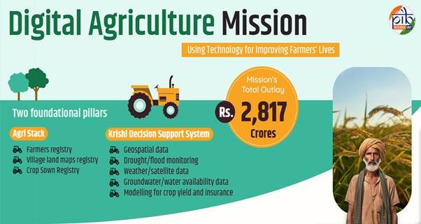
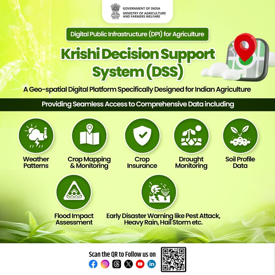
Chapter 5- Krishi Decision Support System (Krishi-DSS)
The Krishi Decision Support System (Krishi-DSS) is an advanced geospatial platform designed to empower Indian agriculture with data-driven solutions. Launched on August 16, 2024, by the Department of Agriculture and Farmers Welfare, Krishi-DSS represents a significant leap in integrating technology into agriculture, often referred to as the “Gati Shakti” for this sector.
Features and Objectives of Krishi-DSS
Krishi-DSS has been conceptualized as a unified platform offering real-time insights on weather patterns, soil health, crop monitoring, and more. Its objectives include:
- Data Centralization: Hosting hundreds of agricultural data layers, including satellite imagery, soil health, groundwater levels, and weather data.
- Stakeholder Empowerment: Providing policymakers, farmers, and researchers with actionable insights.
- Sustainability: Promoting sustainable agricultural practices through better crop rotation, soil conservation, and drought management.
Indigenous Platform for Informed Decision-Making
Krishi-DSS integrates data from RISAT-1A Earth Observation Satellite, MOSDAC, and BHUVAN Geoplatform (developed by ISRO) and systems like VEDAS for seamless decision-making. This integration allows stakeholders to access reliable, high-resolution geospatial data even in challenging conditions.
Key Features:
- Real-time Crop Monitoring: Tracks crop acreage, health, and residue burning.
- Drought Monitoring: Provides near-real-time data on soil moisture, water storage, and dry spells.
- Field Parcel Segmentation: Enables tailored interventions by analyzing individual field parcels.
- Soil Information: Facilitates sustainable practices through data on soil type, pH, and fertility
Applications Towards Sustainable Agriculture
- Improved Crop Management: Parcel-level analysis aids in targeted interventions, enhancing productivity.
- Disaster Preparedness: Early warnings for pests, heavy rainfall, or hailstorms mitigate risks.
- Policy Development: Evidence-based policymaking becomes possible with precise data.
- Insurance Solutions: Accurate assessment of flood and drought impacts enables fair compensation.
Bridging the Gap: Stakeholder Benefits
Krishi-DSS connects farmers, scientists, and policymakers, ensuring informed decisions at every level:
- Farmers: Receive personalized advisories for crop suitability, irrigation, and fertilizers.
- Researchers: Leverage spectral libraries and ground truth data for innovation.
- Policymakers: Use analytics for crafting region-specific agricultural policies.
Integration with the Digital Agriculture Mission
Krishi-DSS is a part of the broader Digital Agriculture Mission, launched with a financial outlay of ₹2,817 crores. This mission includes initiatives such as:
- Agri Stack: A digital repository aimed at revolutionizing agricultural services.
- Soil Profile Mapping: Enables precision agriculture by providing granular soil data.
- Digital Public Infrastructure (DPI): Supports IT initiatives across central and state governments.
Challenges and the Way Forward
Challenges:
- Digital Divide: Limited access to digital infrastructure in rural areas.
- Capacity Building: Lack of technical expertise among farmers and local officials.
- Data Privacy: Concerns regarding the misuse of agricultural data.
Recommendations:
- Infrastructure Development: Enhance internet connectivity in rural areas.
- Training Programs: Educate stakeholders on using digital platforms effectively.
- Policy Safeguards: Ensure robust data protection mechanisms.
Conclusion
Krishi-DSS is more than a technological innovation; it is a transformative step toward achieving sustainable and resilient agriculture in India. By integrating cutting-edge geospatial technologies with real-time data, it empowers stakeholders, enhances productivity, and promotes sustainability. As part of the Digital Agriculture Mission, Krishi-DSS holds the potential to redefine Indian agriculture, ensuring food security and rural prosperity for generations to come.
Upsc Mains Practice Questions-(Around 250 Words)
Q1. Examine the role of Krishi-DSS in transforming Indian agriculture. How can geospatial platforms aid sustainable development and disaster management? Discuss challenges and suggest solutions.”
Q2. Discuss the applications of space technology in agriculture with a focus on enhancing productivity, sustainability, and disaster management. Highlight key initiatives by India in this regard.
QUICK LINKS